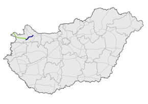
M85 expressway (Hungary)
| |
|---|---|
| M85 autópálya | |
 | |
| Route information | |
|
Part of | |
| Length |
28 km (17 mi) 80 km (50 mi) planned |
| Major junctions | |
| From |
|
|
| |
| To |
Sopron |
| Location | |
| Counties | Győr-Moson-Sopron |
| Major cities | Győr, Csorna, Sopron |
| Highway system | |
_Otszogletu_kek_tabla.svg.png)
The M85 expressway (Hungarian: M85-ös autóút) is a Hungarian expressway connecting Győr to Sopron. It will eventually connect M1 motorway to the Austrian border.
Municipalities
The M85 expressway runs through the following municipalities:
Openings timeline
Junctions, exits and rest area
| M1 (Győr) – Sopron (94 km) | ||||
| 0 km | Budapest / Hegyeshalom | M1 | ||
| Győr / Ikrény, Csorna | ||||
| 8 km | Rábapatona | 84128 | ||
| 10 km | Enese, Tét / Lébény, Bezi | 8417 | ||
| 16 km | Kóny / Rábcakapi | |||
| 21 km | Csorna / Babarcs | |||
| 23 km | Csorna-east, Bősárkány, Mosonmagyaróvár | Csorna bypass, 86 turns toward -> | ||
| Railway Line 8 (Győr-Sopron) | ||||
| 25 km | Railway Line 14 (Pápa-Csorna) | |||
| 27 km | Szombathely, Rédics | Csorna bypass, M86-86 turns toward -> | ||
| 28 km | Railway Line 16 (Hegyeshalom-Szombathely) | |||
| 31 km | Csorna-west, Farád | |||
Toll
From February 1, 2016, the M85 expressway is fully charged. The motorway can be used instead of the national sticker with the following county stickers:
| Type of vignette | Available section |
|---|---|
| Győr-Moson-Sopron County | full length (0 km – 27 km) |
See also
References
External links
| Wikimedia Commons has media related to Autópálya M85. |
- National Toll Payment Services Plc. (in Hungarian, some information also in English)
- National Infrastructure Developer Ltd. (in Hungarian)
- Exit list of M85 in motorways-exitlists.com
| Motorways |  | |
|---|---|---|
| Expressways | ||
This article is issued from
Wikipedia.
The text is licensed under Creative Commons - Attribution - Sharealike.
Additional terms may apply for the media files.