Lower Mesa Falls
| Lower Mesa Falls | |
|---|---|
 | |
| Location | Fremont County, Idaho |
| Coordinates | 44°10′5″N 111°19′11″W / 44.16806°N 111.31972°WCoordinates: 44°10′5″N 111°19′11″W / 44.16806°N 111.31972°W[1] |
| Elevation | 5,518 feet (1,682 m) |
| Total height | 65 feet (20 m) |
| Watercourse | Henrys Fork |
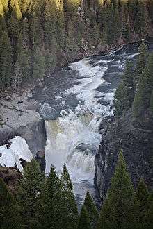
Lower Mesa Falls is a 65-foot (20 m) waterfall on the Henrys Fork in Fremont County, Idaho. It is located in the Caribou-Targhee National Forest on the Mesa Falls Scenic Byway.[2] It is downstream of Upper Mesa Falls.
See also
| Wikimedia Commons has media related to Lower Mesa Falls. |
References
- ↑ "Lower Mesa Falls". Geographic Names Information System. United States Geological Survey.
- ↑ "Idaho Scenic Byways-Mesa Falls". Retrieved 2010-05-08.

This article is issued from
Wikipedia.
The text is licensed under Creative Commons - Attribution - Sharealike.
Additional terms may apply for the media files.