Lo-En
| Lo-En | |
|---|---|
_Guyot.png) Bathymetry of Lo-En Guyot | |
| Summit depth | 1,080 metres (3,540 ft) |
| Height | 4,561 ± 526 metres (14,964 ± 1,726 ft) |
| Summit area | 823 square kilometres (318 sq mi) |
| Location | |
| Coordinates | 10°07′N 162°48′E / 10.117°N 162.800°E[1]Coordinates: 10°07′N 162°48′E / 10.117°N 162.800°E[1] |
| Country | Marshall Islands |
| Geology | |
| Type | Guyot |
Lo-En or Hess is an Albian-Campanian guyot in the Marshall Islands. One among a number of seamounts in the Pacific Ocean, it was probably formed by a hotspot in what is present-day French Polynesia. Limalok lies southeast of Eniwetok which rise above sea level and Lo-En is almost connected to it through a ridge.
The seamount is formed by basaltic rocks that probably formed a shield volcano first. It is believed that a number of hotspots such as the Macdonald hotspot, the Rarotonga hotspot and the Rurutu hotspot may have been involved in the formation of Lo-En. After the volcanic episode, the seamount was submerged by Turonian times although it is possible that a carbonate platform formed during the Albian. After a hiatus, sedimentation commenced on the seamount in Oligocene time and led to the deposition of manganese crusts and pelagic sediments including limestone, some of which were later modified by phosphate.
Name and research history
Lo-En is a reference to the hibiscus tree,[2] the seamount was formerly known as Hess Guyot.[3] This seamount was targeted for drilling in the Ocean Drilling Program.[4]
Geography and geology
Local setting
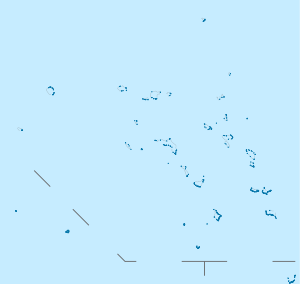
Lo-En lies within the northern Marshall Islands,[5] less than 150 kilometres (93 mi) south-southeast from Eniwetok.[6] It is part of a cluster of seamounts and islands that surrounds Eniwetok, but also appears to be part of a chain running parallel to the Ralik Chain and the Ratak Chain, two seamount-and-island chains in the Marshall Islands.[7]
The seamount rises 4,561 ± 526 metres (14,964 ± 1,726 ft) above the seafloor[8] to a depth of 1,080 metres (3,540 ft) below sea level.[1] Lo-En is elongated in north-south direction[6] and has a flat top[9] with dimensions of 30 by 40 kilometres (19 mi × 25 mi)[10] and a surface area of 823 square kilometres (318 sq mi),[11] it is a typical guyot.[12] A volcanic pinnacle is embedded in the sediments on top of Lo-En, it is either a volcanic formation that resisted erosion or a volcanic vent that was active after Lo-En was submerged,[13] there are other cones which emerge from the sediments[14] and which appear to be of volcanic origin in light of the dredged rocks, as well as lobate structures. Terraces occur on Lo-En's southwestern rim[10] and may be products of landsliding.[15] The seamount is normally magnetized[3] and it features distinct forms when examined magnetometrically.[16]
No carbonate cap[4] or limestones have been found on the platform of Lo-En, unlike in several other guyots of the region;[17] a drill core at Lo-En found pelagic sediments directly on the volcanic basement.[18] However, remains of reefs and of lagoonal sediments have been detected on seismic profiles[13] although the existence of a barrier reef has been questioned,[19] and Lo-En has a 141.7–143.6 metres (465–471 ft) thick pelagic sediment cap.[20] It is possible that shallow water limestones exist at the margins of the platform, which were not drilled.[21]
Lo-En shares its volcanic edifice with Eniwetok,[22] a northern spur from Lo-En almost reaches Eniwetok[6] while another spur emerges in south-southeast direction[10] and is about 14.5 kilometres (9.0 mi) long.[23] Another seamount lies 50 kilometres (31 mi) farther west from Lo-En.[6] The seafloor underneath Lo-En is 113[1]-156.9 ± 5 million years old[8] and lies at a depth of over 5 kilometres (3.1 mi).[6]
Regional setting
-1.svg.png)
The Pacific Ocean seafloor, especially the parts that are of Mesozoic age, contains most of the world's guyots. These are flat-topped submarine mountains[24] which are characterized by steep slopes, a flat top and usually the presence of corals and carbonate platforms.[25] It is not clear whether the Cretaceous guyots were atolls in the present-day sense[26] but many of these seamounts were, which today still exist. All these structures originally formed as volcanoes in the Mesozoic Ocean. First fringing reefs may have developed on the volcanoes, which then became barrier reefs as the volcano subsided and turned into an atoll. Continued subsidence balanced by upward growth of the reefs led to the formation of thick carbonate platforms.[27] Sometimes volcanic activity occurred even after the formation of the atoll or atoll-like landforms, and during episodes where the carbonate platforms were lifted above sea level erosional features such as channels and blue holes developed.[28] The crust underneath these seamounts tends to subside as it cools and thus the islands and seamounts sink.[29]
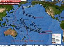
The formation of many such seamounts[30] including Limalok[31] has been explained with the hotspot theory, which discusses the formation of chains of volcanoes which get progressively older along the length of the chain, with an active volcano only at one end of the system.[30] Seamounts and islands in the Marshall Islands do not appear to have originated from such simple age-progressive hotspot volcanism as the age progressions in the individual island and seamount chains are often inconsistent with a hotspot origin.[32] One solution to this dilemma may be that more than one hotspot passed through the Marshall Islands,[33] as well as the possibility that hotspot volcanism is affected by contemporaneous lithospheric extension.[34]
Candidate hotspots responsible for the formation of Lo-En are the Macdonald hotspot which passed close to Lo-En between 115-105 million years ago and the Rarotonga hotspot and Rurutu hotspot, both of which were at Lo-En between 90 and 74 million years ago,[35] the first two also have the strongest geochemical similarity to Lo-En.[36] In the case of Lo-En, volcanism on the Ogasawara Fracture Zone may also have contributed to its formation[7] considering that it is much older than surrounding seamounts.[1]
Based on plate motion reconstructions, the region of the Marshall Islands was located in the region of present-day French Polynesia during the time of active volcanism. Both regions display numerous island chains, anomalously shallow ocean floors and the presence of volcanoes.[37] About 8 hotspots have formed a large number of islands and seamounts in that region, with disparate geochemistries,[38] that geological province has been called "South Pacific Isotopic and Thermal Anomaly" or DUPAL anomaly.[39]
Composition
Lo-En has erupted alkali basalt[5] and hawaiite.[1] Minerals contained in the rocks include apatite,[40] biotite,[41] clinopyroxene, ilmenite, magnetite and plagioclase.[40] Strong alteration has occurred[42] and has given rise to calcite, carbonate, chabazite, clay, hematite, smectite and zeolite,[43][40] as well as palagonite.[14] Other rocks found on Lo-En are chalk, limestone, manganese crusts, phosphate[22] and sandstone.[5]
Geologic history
The geologic history of Lo-En seamount is relatively poorly known,[44] paleomagnetic data have been used to infer an age of 45-85 million years ago for the seamount.[45] It was located at about 25[46]-30 degrees southern latitude when it formed, south of the hotspots that are presently active in the Cook Islands-Austral Islands.[1] Eniwetok is about 36 million years younger than Lo-En.[47]
Volcanism and first biotic phenomena
A first phase of volcanic activity occurred 114 million years ago, and was followed by a second episode during the Campanian,[48] separated by as much as 30 million years.[49] The first episode has been dated at 111.6 - 114.0 million years ago[50] and was contemporaneous with volcanic activity at other western Pacific seamounts. The second episode may be responsible for the cones that emerge from or are embedded in sediments that cover Lo-En. Eniwetok was active 76.9 million years ago[14] and flexural effects from its growth may have influenced the second volcanic phase at Lo-En.[51] Potentially, the first episode was caused by the Macdonald hotspot and the second by the Rarotonga and Rurutu hotspots.[35]
The volcanic rocks encountered in drill cores consist of breccia and lava flows.[5] Their alkalic composition implies that they may be post-shield volcanics.[52] Claystones indicate that weathered terrain occurred on Lo-En,[9] with subaerial alteration of volcanic rocks.[53]
Post-volcanic
Lo-En was submerged in the Turonian[21] by about 112.8 ± 1.2 million years ago, long before surrounding seamounts and islands formed.[1] The absence of a barrier reef would have facilitated the erosion of Lo-En's summit.[51] It is possible that flexural loading by Eniwetok pushed Lo-En downward and thus prevented the formation of reefs on Lo-En during the Cretaceous when the seamount was uplifted by a hotspot.[54] It took about 2 to 7 million years from the end of volcanic activity until sedimentation began.[55]
During the Albian, limestones were emplaced on Lo-En.[17] These appear to reflect the formation of reefs[56] and a shallow carbonate bank, material from which has been dredged on the southern flank.[57] This platform drowned during the late Albian, similar to many other carbonate platforms of similar age,[58] and there is no evidence of mid-Cretaceous platforms.[47]
Starting in the Albian-Cenomanian,[12] pelagic limestone was deposited directly on the volcanic rocks during Santonian-Coniacian times; in light of fossil data it is likely that the seamount was not overly deep at that time.[59] Sediments of Cretaceous-Paleocene age reach thicknesses of less than 1 metre (3 ft 3 in).[22]
Starting in the Oligocene,[57][60] pelagic oozes were deposited on Lo-En. The previously emplaced limestones also underwent phosphate reactions as they were exposed on the seafloor,[59] and some of the sediments underwent reworking.[22]
Foraminifera encountered on the seamount in the form of nannofossils are:[59]
- Arkangelskiella specillata
- Aspidolithus parcus expansus
- Eiffellithus eximius
- Gephyrorhabdus coronadventis
- Lithastrinus septenarius
- Micula sp.
- Nannoconus farinacciae
- Reinhardtites sp.
- Stoverius sp.
References
- 1 2 3 4 5 6 7 8 Koppers et al. 1995, p. 538.
- ↑ Hein, J.R.; Kang, Jung-Keuk; Schulz, M.S.; Park, Byong-Kwon; Kirschenbaum, Herbert; Yoon, Suk-Hoon; Olson, R.L.; Smith, V.K.; Park, Dong-Won (1990). "Geological, geochemical, geophysical, and oceanographic data and interpretations of seamounts and co-rich ferromanganese crusts from the Marshall Islands, KORDI-USGS R.V. FARNELLA cruise F10-89-CP". Open-File Report: 245. ISSN 2331-1258.
- 1 2 Bryan et al. 1993, p. 388.
- 1 2 Watkins et al. 1995, p. 675.
- 1 2 3 4 Kurnosov et al. 1995, p. 475.
- 1 2 3 4 5 Bryan et al. 1993, p. 390.
- 1 2 Koppers et al. 1995, p. 537.
- 1 2 Caplan-Auerbach, Duennebier & Ito 2000, p. 2687.
- 1 2 Larson et al. 1995, p. 922.
- 1 2 3 Bergersen 1995, p. 566.
- ↑ Bergersen 1995, p. 567.
- 1 2 Erba et al. 1995, p. 884.
- 1 2 Caplan-Auerbach, Duennebier & Ito 2000, p. 2689.
- 1 2 3 Haggerty & Premoli Silva 1995, p. 938.
- ↑ Bergersen 1995, p. 570.
- ↑ Bryan et al. 1993, p. 395.
- 1 2 Erba, Premoli Silva & Watkins 1995, p. 157.
- ↑ Erba et al. 1995, p. 873.
- ↑ Bergersen 1995, p. 572.
- ↑ Bogdanov et al. 1995, p. 747.
- 1 2 "Insight on the formation of Pacific guyots from ODP Leg 144". Eos, Transactions American Geophysical Union. 74 (32): 358. 1993. doi:10.1029/93eo00458. ISSN 0096-3941. (Subscription required (help)).
- 1 2 3 4 Watkins et al. 1995, p. 678.
- ↑ Bergersen 1995, p. 569.
- ↑ Camoin, G. F.; Arnaud-Vanneau, A.; Bergersen, D. D.; Enos, P.; Ebren, Ph. (27 May 2009). "Development and Demise of Mid-Oceanic Carbonate Platforms, Wodejebato Guyot (NW Pacific)". Reefs and Carbonate Platforms in the Pacific and Indian Oceans. Blackwell Publishing Ltd.: 39. doi:10.1002/9781444304879.ch3. ISBN 9781444304879.
- ↑ Arnaud Vanneau et al. 1995, p. 819.
- ↑ Ogg, J.G.; Camoin, G.F.; Arnaud Vanneau, A. (December 1995), "Limalok Guyot: Depositional History of the Carbonate Platform from Downhole Logs at Site 871 (Lagoon)" (PDF), Proceedings of the Ocean Drilling Program, 144 Scientific Results, Ocean Drilling Program, p. 236, doi:10.2973/odp.proc.sr.144.042.1995, retrieved 2018-07-10
- ↑ Pringle et al. 1993, p. 359.
- ↑ Pringle et al. 1993, p. 360.
- ↑ Larson et al. 1995, p. 916.
- 1 2 Koppers et al. 2003, p. 2.
- ↑ Arnaud Vanneau et al. 1995, p. 833.
- ↑ Pringle et al. 1993, p. 368.
- ↑ Pringle et al. 1993, p. 299.
- ↑ Koppers et al. 2003, p. 35.
- 1 2 Haggerty & Premoli Silva 1995, p. 939.
- ↑ Koppers et al. 2003, p. 25.
- ↑ Bergersen 1995, p. 561.
- ↑ Koppers et al. 1995, p. 535.
- ↑ Dieu, J.J. (December 1995), "Mineral Compositions in Leg 144 Lavas and Ultramafic Xenoliths: The Roles of Cumulates and Carbonatite Metasomatism in Magma Petrogenesis" (PDF), Proceedings of the Ocean Drilling Program, 144 Scientific Results, Ocean Drilling Program, p. 513, doi:10.2973/odp.proc.sr.144.029.1995, retrieved 2018-07-14
- 1 2 3 Koppers et al. 1995, p. 539.
- ↑ Kurnosov et al. 1995, p. 476.
- ↑ Kurnosov et al. 1995, p. 484.
- ↑ Kurnosov et al. 1995, p. 479.
- ↑ Larson et al. 1995, p. 928.
- ↑ Bryan et al. 1993, p. 399.
- ↑ Haggerty & Premoli Silva 1995, p. 941.
- 1 2 Bergersen 1995a, p. 605.
- ↑ Larson et al. 1995, p. 917.
- ↑ Bergersen 1995, p. 564.
- ↑ Bergersen 1995a, p. 606.
- 1 2 Bergersen 1995, p. 577.
- ↑ Haggerty & Premoli Silva 1995, p. 942.
- ↑ Kurnosov et al. 1995, p. 487.
- ↑ Bergersen 1995, p. 575.
- ↑ Haggerty & Premoli Silva 1995, p. 947.
- ↑ Haggerty & Premoli Silva 1995, p. 943.
- 1 2 Larson et al. 1995, p. 924.
- ↑ Larson et al. 1995, p. 929.
- 1 2 3 Erba, Premoli Silva & Watkins 1995, p. 158.
- ↑ Bogdanov et al. 1995, p. 748.
Sources
- Arnaud Vanneau, A.; Bergersen, D.D.; Camoin, G.F.; Ebren, P.; Haggerty, J.A.; Ogg, J.G.; Premoli Silva, I.; Vail, P.R. (December 1995), "A Model for Depositional Sequences and Systems Tracts on Small, Mid-Ocean Carbonate Platforms: Examples from Wodejebato (Sites 873-877) and Limalok (Site 871) Guyots" (PDF), Proceedings of the Ocean Drilling Program, 144 Scientific Results, Ocean Drilling Program, doi:10.2973/odp.proc.sr.144.001.1995, retrieved 2018-07-10
- Bergersen, D.D. (December 1995), "Physiography and Architecture of Marshall Islands Guyots Drilled during Leg 144: Geophysical Constraints on Platform Development" (PDF), Proceedings of the Ocean Drilling Program, 144 Scientific Results, Ocean Drilling Program, doi:10.2973/odp.proc.sr.144.019.1995, retrieved 2018-07-15
- Bergersen, D.D. (December 1995a), "Cretaceous Hotspot Tracks through the Marshall Islands" (PDF), Proceedings of the Ocean Drilling Program, 144 Scientific Results, Ocean Drilling Program, doi:10.2973/odp.proc.sr.144.018.1995, retrieved 2018-07-15
- Bogdanov, Y.A.; Bogdanova, O.Y.; Dubinin, A.V.; Gorand, A.; Gorshkov, A.I.; Gurvich, E.G.; Isaeva, A.B.; Ivanov, G.V.; Jansa, L.F. (December 1995), "Composition of Ferromanganese Crusts and Nodules at Northwestern Pacific Guyots and Geologic and Paleoceanographic Considerations" (PDF), Proceedings of the Ocean Drilling Program, 144 Scientific Results, Ocean Drilling Program, doi:10.2973/odp.proc.sr.144.057.1995, retrieved 2018-07-15
- Bryan, Phillip C.; Shoberg, Tom; Gordon, Richard G.; Petronotis, Katerina E.; Bergersen, Douglas D. (1993), "A paleomagnetic pole and estimated age for Lo-En Guyot, Republic of the Marshall Islands", The Mesozoic Pacific: Geology, Tectonics, and Volcanism: A Volume in Memory of Sy Schlanger, American Geophysical Union, pp. 387–400, doi:10.1029/gm077p0387, ISBN 0875900364, retrieved 2018-07-15, (Subscription required (help))
- Caplan-Auerbach, Jacqueline; Duennebier, Fred; Ito, Garrett (10 February 2000). "Origin of intraplate volcanoes from guyot heights and oceanic paleodepth". Journal of Geophysical Research: Solid Earth. 105 (B2): 2679–2697. doi:10.1029/1999JB900386.
- Erba, E.; Premoli Silva, I.; Watkins, D.K. (December 1995), "Cretaceous Calcareous Plankton Biostratigraphy of Sites 872 through 879" (PDF), Proceedings of the Ocean Drilling Program, 144 Scientific Results, Ocean Drilling Program, doi:10.2973/odp.proc.sr.144.071.1995, retrieved 2018-07-15
- Erba, E.; Premoli Silva, I.; Wilson, P.A.; Pringle, M.S.; Sliter, W.V.; Watkins, D.K.; Arnaud Vanneau, A.; Bralower, T.J.; Budd, A.F. (December 1995), "Synthesis of Stratigraphies from Shallow-Water Sequences at Sites 871 through 879 in the Western Pacific Ocean" (PDF), Proceedings of the Ocean Drilling Program, 144 Scientific Results, Ocean Drilling Program, doi:10.2973/odp.proc.sr.144.076.1995, retrieved 2018-07-15
- Haggerty, J.A.; Premoli Silva, I. (December 1995), "Comparison of the Origin and Evolution of Northwest Pacific Guyots Drilled during Leg 144" (PDF), Proceedings of the Ocean Drilling Program, 144 Scientific Results, Ocean Drilling Program, doi:10.2973/odp.proc.sr.144.074.1995, retrieved 2018-07-15
- Koppers, A.A.P.; Staudigel, Hubert; Christie, D.M.; Dieu, J.J.; Pringle, Malcolm S. (December 1995), "Sr-Nd-Pb Isotope Geochemistry of Leg 144 West Pacific Guyots: Implications for the Geochemical Evolution of the "SOPITA" Mantle Anomaly" (PDF), Proceedings of the Ocean Drilling Program, 144 Scientific Results, Ocean Drilling Program, doi:10.2973/odp.proc.sr.144.031.1995, retrieved 2018-07-15
- Koppers, Anthony A. P.; Staudigel, Hubert; Pringle, Malcolm S.; Wijbrans, Jan R. (October 2003). "Short-lived and discontinuous intraplate volcanism in the South Pacific: Hot spots or extensional volcanism?". Geochemistry, Geophysics, Geosystems. 4 (10). doi:10.1029/2003gc000533. ISSN 1525-2027.
- Kurnosov, V.; Zolotarev, B.; Eroshchev-Shak, V.; Artamonov, A.; Kashinzev, Murdmaa (December 1995), "Alteration of Basalts from the West Pacific Guyots, Legs 143 and 144" (PDF), Proceedings of the Ocean Drilling Program, 144 Scientific Results, Ocean Drilling Program, doi:10.2973/odp.proc.sr.144.068.1995, retrieved 2018-07-15
- Larson, R.L.; Erba, E.; Nakanishi, M.; Bergersen, D.D.; Lincoln, J.M. (December 1995), "Stratigraphic, Vertical Subsidence, and Paleolatitude Histories of Leg 144 Guyots" (PDF), Proceedings of the Ocean Drilling Program, 144 Scientific Results, Ocean Drilling Program, doi:10.2973/odp.proc.sr.144.063.1995, retrieved 2018-07-15
- Pringle, Malcolm S.; Sager, William W.; Sliter, William V.; Stein, Seth, eds. (1993). "The Mesozoic Pacific: Geology, Tectonics, and Volcanism: A Volume in Memory of Sy Schlanger". Geophysical Monograph Series. Geophysical Monograph Series. 77. doi:10.1029/gm077. ISBN 0-87590-036-4. ISSN 0065-8448. (Subscription required (help)).
- Watkins, D.K.; Pearson, P.N.; Erba, E.; Rack, F.R.; Premoli Silva, I.; Bohrmann, H.W.; Fenner, J.; Hobbs, P.R.N. (December 1995), "Stratigraphy and Sediment Accumulation Patterns of the Upper Cenozoic Pelagic Carbonate Caps of Guyots in the Northwestern Pacific Ocean" (PDF), Proceedings of the Ocean Drilling Program, 144 Scientific Results, Ocean Drilling Program, doi:10.2973/odp.proc.sr.144.066.1995, retrieved 2018-07-15
Marshall Islands articles | |||||||
|---|---|---|---|---|---|---|---|
| History | |||||||
| Geography |
| ||||||
| Politics | |||||||
| Economy |
| ||||||
| Culture |
| ||||||
| |||||||