Jaluit Atoll
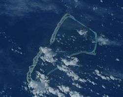 NASA image of Jaluit Atoll | |
 Jaluit | |
| Geography | |
|---|---|
| Location | North Pacific |
| Coordinates | 05°55′18″N 169°38′33″E / 5.92167°N 169.64250°E |
| Archipelago | Ralik |
| Total islands | 91 |
| Area | 11.34 km2 (4.38 sq mi) |
| Highest elevation | 3 m (10 ft) |
| Administration | |
| Demographics | |
| Population | 1,788 (2011) |
| Ethnic groups | Marshallese |
| Official name | Jaluit Atoll Conservation Area |
| Designated | 13 July 2004 |
| Reference no. | 1389[1] |
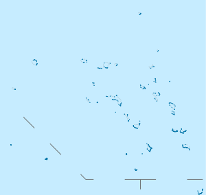
Jaluit Atoll (Marshallese: Jālwōj, [tʲælʲo̯o͡etʲ], or Jālooj, [tʲælʲe͡oː͡etʲ][2]) is a large coral atoll of 91 islands in the Pacific Ocean and forms a legislative district of the Ralik Chain of the Marshall Islands. Its total land area is 11.34 square kilometres (4.38 sq mi), and it encloses a lagoon with an area of 690 square kilometres (270 sq mi). Most of the land area is on the largest islet (motu) of Jaluit (10.4 km²). Jaluit is approximately 220 kilometres (140 mi) southwest of Majuro. Jaluit Atoll is a designated conservation area and Ramsar Wetland.
In 2011 the population of the islands of Jaluit Atoll was 1,788. It was the former administrative seat of the Marshall Islands.
History
The British merchant vessel Rolla sighted Jaluit in 1803.[3] She had transported convicts from Britain to New South Wales and was on her way to China to find a cargo to take back to Britain.
In 1884, the German Empire claimed Jaluit Atoll, along with the rest of the Marshall Islands, and the Germans established a trading outpost. Jaluit became a German protectorate on 13 September 1886 and had several imperial commissars (Kaiserliche Kommissare):
- 11 May 1894 – March 1898 Georg Irmer (b. 1853 – d. 1931)
- 24 March 1898 – 18 January 1906 Eugen Brandeis (b. 1846 – d. 1919) (acting to 22 February 1900)
- 18 January 1906 – May 1906 Ludwig Kaiser (acting) (b. 1862 – d. 1906)
- 1 April 1906 – 3 October 1914 the governors of German New Guinea; afterwards the jurisdiction was downgraded to district, under a Bezirksamtmann
After World War I, the island became a part of Nanyo, a mandated territory of the Empire of Japan, and was the seat of the Japanese administration over the Marshall Islands. Immigrants from Japan numbered several hundred by the 1930s. During World War II the island's Japanese garrison consisted of 1,584 men of the Imperial Japanese Navy and 727 men of the Imperial Japanese Army.[4] The island was bombed on at least five occasions in November and December 1943 by B-24 Liberator bombers of the USAAF 7th Air Force.
Following World War II, Jaluit came under the control of the United States as part of the Trust Territory of the Pacific Islands until the independence of the Marshall Islands in 1986.
Geography
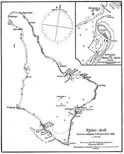
Jaluit Atoll's lagoon is shaped roughly like a kite.
The islet of Jabor (Jebwad, [tʲɛ͡ʌbˠɒ̯ɒ͡ær̪ʲ][5]) has the largest population center on Jaluit Atoll, with a population of approximately 1,200. The island features a small hotel, small stores that sell staple foods, and a gasoline station. Jabor is a base for commercial and sports fishing, where motorboats can be rented. Snorkeling spots are around the sunken dock by the airport and in the northern pass into the lagoon.
Imiej (Im̧wej, [i̯i͡ɯmˠe̯etʲ][5]) is an islet a 45-minute boat ride from Jabor. It used to be the headquarters for the Imperial Japanese Navy garrison and was a major seaplane base. The ruins of the power station, barracks, antiaircraft guns and a Shinto shrine remain.
Education
Marshall Islands Public School System operates public schools.
High schools:[6]
- Jaluit High School (JHS) - a boarding school that serves students from Jaluit Atoll and the southern atolls of Ebon, Ailinglaplap, Namu, Kili, Namdrik and Jabat.[7]
Primary schools:[8]
- Imiej Elementary School
- Imroj Elementary School
- Jabnoden Elementary School
- Jabor Elementary School - Jabor
- Jaluit Elementary School
- Mejrirok Elementary School
- Narmej Elementary School
Private schools: Jabor has St. Josephs, attached to the Catholic Church
Transportation
Jaluit Airport is served by Air Marshall Islands.
Notes
- ↑ "Jaluit Atoll Conservation Area". Ramsar Sites Information Service. Retrieved 25 April 2018.
- ↑ "Marshallese-English Dictionary - Place Name Index".
- ↑ Hezel (1994), p. 82.
- ↑ Takizawa, Akira; Alsleben, Allan (1999–2000). "Japanese garrisons on the by-passed Pacific Islands 1944-1945". Forgotten Campaign: The Dutch East Indies Campaign 1941-1942. Archived from the original on 2016-01-06.
- 1 2 Marshallese-English Dictionary
- ↑ "Secondary Schools Division ." Marshall Islands Public School System. Retrieved on February 21, 2018.
- ↑ http://www.pacificmagazine.net/news/2008/06/01/power-cuts-increase-jaluits-remoteness
- ↑ "Public Schools ." Marshall Islands Public School System. Retrieved on February 21, 2018.
References
- L, Klemen (1999–2000). "Forgotten Campaign: The Dutch East Indies Campaign 1941-1942". Archived from the original on 2011-07-26.
External links
| Wikimedia Commons has media related to Jaluit. |
- Marshall Islands site
- Entry at Oceandots.com at the Wayback Machine (archived December 23, 2010)
- Surrender of Jaluit to the United States
Marshall Islands articles | |||||||
|---|---|---|---|---|---|---|---|
| History | |||||||
| Geography |
| ||||||
| Politics | |||||||
| Economy |
| ||||||
| Culture |
| ||||||
| |||||||