Ailinginae Atoll
 NASA photo of Ailinginae Atoll | |
 Ailinginae Atoll Location in the Marshall Islands | |
| Geography | |
|---|---|
| Location | North Pacific |
| Coordinates | 11°10′N 166°20′E / 11.167°N 166.333°E |
| Archipelago | Ralik |
| Total islands | 25 |
| Area | 2.8 km2 (1.1 sq mi) |
| Highest elevation | 3 m (10 ft) |
| Administration | |
| Demographics | |
| Population | 0 |
| Ethnic groups | Marshallese (former) |
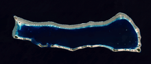
Ailinginae Atoll (Marshallese: Aelōn̄in Ae, [ɑ̯ɑ͡æe̯elʲe͡ɤŋɯ͡inʲ-ɑ̯ɑ͡æɛ̯ɛɛ̯][1]) is an uninhabited (due to Castle Bravo nuclear testing) coral atoll of 25 islands in the Pacific Ocean, on the northern end of the Ralik Chain of the Marshall Islands. Its total land area is only 2.8 square kilometres (1.1 sq mi), but it encloses a lagoon of 105.96 square kilometres (40.91 sq mi). It is located approximately 13 kilometres (8.1 mi) west of Rongelap Atoll. The landscape is low-lying with only the top 3 metres above sea level. The two entrances into the lagoon are 'Mogiri Pass' and 'Eniibukku Pass'. These are 0.9 and 0.3 miles wide respectively.
The average temperature of these islands is about 27 °C (81 °F) during daytime and slightly warmer during night-time due to cold weather associated with rain showers during daytime. The rainy season is from September through November. The island is covered with scrub, grasses and some stands of Casuarina trees.
History
First sighting recorded by Europeans was by the Spanish navigator Álvaro de Saavedra on 1 January 1528. Together with Utirik Atoll and Rongelap Atoll, they were charted as Islas de los Reyes (Islands of the Three Wise Kings in Spanish) due to the proximity of Epiphany[2]
Ailinginae Atoll was claimed by the Empire of Germany along with the rest of the Marshall Islands in 1884. After World War I, the island came under the South Pacific Mandate of the Empire of Japan. Following the end of World War II, it came under the control of the United States as part of the Trust Territory of the Pacific Islands until the independence of the Marshall Islands in 1986. Ailinginae Atoll has been uninhabited since 1954 when the few islanders were evacuated due to nuclear fallout fears from the Castle Bravo test at Bikini Atoll to the northwest.
See also
- Also contaminated by Castle Bravo test: Rongelap Atoll, Utirik Atoll, Rongerik Atoll
References
- ↑ Marshallese-English Dictionary - Place Name Index
- ↑ Brand, Donald D. The Pacific Basin: A History of its Geographical Explorations The American Geographical Society, New York, 1967, p.121
- Ailinginae Atoll Fact Sheet==External links==
- "Oceandots site". Archived from the original on 2010-12-23. Retrieved 2010-07-23.
- Marshall Islands site
- Map of Ailinginae Atoll 1893
- Geography of the Marshall Islands, including Ailinginae Atoll
Marshall Islands articles | |||||||
|---|---|---|---|---|---|---|---|
| History | |||||||
| Geography |
| ||||||
| Politics | |||||||
| Economy |
| ||||||
| Culture |
| ||||||
| |||||||