Kaben
Kaben or Kaven is a small island in the Maloelap Atoll in the Republic of the Marshall Islands. Situated at the northwestern most tip of the atoll, it is the largest island and one of the few inhabited ones on the atoll. Together with a few other small islands, it forms part of the "outer islands" of the Marshalls[1]
Geography
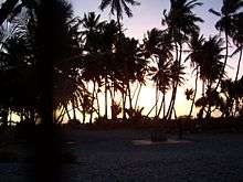
Kaben is a small island, no more than 2.5 kilometers long and a kilometer across. The island has around 1-square-mile (2.6 km2) in area. It is almost rectangularly-shaped, with a slight hooklike protuberance on the northeastern region of the island. Kaben is lightly inhabited, having had a few man-made structures erected along its southeast coast.[2]
History
Historically, the island has been claimed by the Iroij, royalty of the islands, as their personal property prohibiting peasant islanders from fishing the island's waters. Fishing by local islanders only resumed when an official government for the islands was formed and fishing was officially declared permissible.[3] As the largest island in the atoll, Iroij coronation events have traditionally taken place on Kaben. The island has several myths and legends surrounding it and its remote waters.[4]
Fauna
The fauna of the island is similar to that of the other islands in the Marshalls. Terrestrial fauna is limited to small crustaceans such as the hermit crabs Coenobita and land crabs from the family Gecarcinidae.[2] Historically, the island has been cited as the home for a large population of edible coconut crabs.[3]
Airport
The island has an airport, Kaben Airport (IATA: KBT). However, airport is a misnomer. It is a simple airstrip without any major airport facilities. A 2000 Technical Assistance Report by the Asian Development Bank suggested that, for infrastructure development, the runways of several airstrips throughout the Marshall Islands, including the one on Kaben, be rehabilitated. This rehabilitation was suggested to include de-forestation of the vegetation surrounding the airstrip and the construction of adequate aero-navigational facilities.[1]
See also
References
- 1 2 Technical Assistance to the Republic of the Marshall Islands for Preparing the Outer Island Transport Infrastructure Project. TAR: RMI 32208. Asian Development Bank. 2000.
- 1 2 Muller, Frederick; Nancy Vander Velde. Overview of the Marshall Islands' Forest Resources. Marshall Islands: Republic of the Marshall Islands Ministry of Resources, Development and Works. Retrieved 2009-01-12.
- 1 2 McNeely, Jeffrey A.; David C. Pitt (1985). Culture and Conservation: The Human Dimension in Environmental Planning. International Union for Conservation of Nature and Natural Resources. Routledge. p. 308. ISBN 0-7099-1321-4.
- ↑ Aisea, Tonke; Daniel A. Kelin; Nashton T. Nashon (2003). Marshall Islands Legends and Stories. Illustrated by Nashton T. Nashon. Bess Press. p. 252. ISBN 1-57306-141-7.
Bibliography
U.S. Geological Survey Geographic Names Information System: Kaben Coordinates: 8°53′36″N 170°50′42″E / 8.89333°N 170.84500°E
Marshall Islands articles | |||||||
|---|---|---|---|---|---|---|---|
| History | |||||||
| Geography |
| ||||||
| Politics | |||||||
| Economy |
| ||||||
| Culture |
| ||||||
| |||||||