List of power stations in Pennsylvania
This is a list of electricity-generating power stations in Pennsylvania, sorted by type and name.
Coal power stations
| Name | Location (County) | Coordinates | Capacity (MW) | Status |
|---|---|---|---|---|
| Brunner Island Steam Electric Station | York | 40°05′44″N 76°41′49″W / 40.09556°N 76.69694°W | 1567 | Operational |
| Cheswick Generating Station | Allegheny | 40°32′18″N 79°47′29″W / 40.53833°N 79.79139°W | 635 | Operational |
| Conemaugh Generating Station | Indiana | 40°23′05″N 79°03′49″W / 40.38472°N 79.06361°W | 1883 | Operational |
| Homer City Generating Station | Indiana | 40°30′39″N 79°11′37″W / 40.51083°N 79.19361°W | 2022 | Operational |
| Keystone Generating Station | Armstrong | 40°39′36″N 79°20′27″W / 40.66000°N 79.34083°W | 1711 | Operational |
| Bruce Mansfield Power Plant | Beaver | 40°38′06″N 80°24′55″W / 40.63500°N 80.41528°W | 2490 | Operational |
| Montour Power Plant | Montour | 41°04′13″N 76°39′52″W / 41.07028°N 76.66444°W | 1624 | Operational |
Hydroelectric power stations
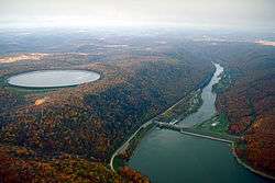
The Seneca Pumped Storage Generating Station reservoir. Kinzua Dam on the Allegheny River can be seen on the left.
| Name | Location (County) | Coordinates | Capacity (MW) | Status |
|---|---|---|---|---|
| Allegheny Hydro Partners (Freeport) | Armstrong | 6 | Operational | |
| Allegheny Hydro Partners No. 6 | Armstrong | 8 | Operational | |
| Allegheny Hydro Partners No. 8 | Armstrong | 13.6 | Operational | |
| Allegheny Hydro Partners No. 9 | Armstrong | 17.8 | Operational | |
| Beaver Valley- Patterson | Beaver | 1.2 | Operational | |
| Conemaugh | Indiana and Westmoreland | 1711 | Operational | |
| Holtwood Dam | Lancaster and York | 39°49′37″N 76°20′07″W / 39.82694°N 76.33528°W | 109 | Operational |
| Mahoning Creek | Armstrong | 6.6 | Operational | |
| Muddy Run Pumped Storage Facility | Lancaster | 39°48′29″N 76°17′53″W / 39.80806°N 76.29806°W | 1,071 | Operational |
| Piney Hydroelectric | Clarion | 27 | Operational | |
| PPL HW Wallenpaupack | Pike and Wayne | 44 | Operational | |
| Safe Harbor Dam | Lancaster and York | 39°55′14″N 76°23′33″W / 39.92056°N 76.39250°W | 422.5 | Operational |
| Seneca Pumped Storage Generating Station | Warren | 41°50′21″N 79°00′13″W / 41.83917°N 79.00361°W | 435 | Operational |
| Townsend Hydro | Beaver | 4.2 | Operational | |
| Warrior Ridge Hydro | Huntingdon | 2.8 | Operational | |
| William F. Matson | Huntingdon | 21 | Operational | |
| York Haven Dam | Dauphin, Lancaster and York | 40°07′03″N 76°42′55″W / 40.11750°N 76.71528°W | 20 | Operational |
| Yough Hydro Power | Fayette & Somerset | 12.2 | Operational |
Source: U.S. Energy Information Administration[1]
Nuclear power stations
-2.jpg)
| Name | Location (County) | Coordinates | Capacity (MW) | Status |
|---|---|---|---|---|
| Beaver Valley Nuclear Generating Station | Beaver | 40°37′23″N 80°25′50″W / 40.62306°N 80.43056°W | 1,835 | Operational |
| Limerick Nuclear Power Plant | Montgomery | 40°13′35″N 75°35′14″W / 40.22639°N 75.58722°W | 2,296 | Operational |
| Peach Bottom Nuclear Generating Station | York | 39°45′30″N 76°16′5″W / 39.75833°N 76.26806°W | 2,251 | Operational |
| Susquehanna Steam Electric Station | Luzerne | 41°5′19″N 76°8′56″W / 41.08861°N 76.14889°W | 2,520 | Operational |
| Three Mile Island Nuclear Generating Station | Dauphin | 40°09′14″N 76°43′29″W / 40.15389°N 76.72472°W | 805 | Operational |
Source: U.S. Energy Information Administration (MW Totals as of August 2014)
Wind power stations
| Name | Location (County) | Number of Wind mills | Capacity (MW) | Status |
|---|---|---|---|---|
| Armenia Mountain Wind | Bradford & Tioga | 71 | 100.5 | Operational |
| Laurel Hill Wind | Lycoming | 31 | 69 | Operational |
| Locust Ridge | Schuylkill | 12 | 26 | Operational |
| Locust Ridge II | Schuylkill | 25 | 102 | Operational |
| Mehoopany Wind Energy | Wyoming | 86 | 142.6 | Operational |
| Sandy Ridge Wind Farm | Blair & Centre | 25 | 48.2 | Operational |
| Waymart Wind | Wayne | 43 | 64.5 | Operational |
| Wind Park- Bear Creek | Luzerne | 12 | 24 | Operational |
Source: U.S. Energy Information Administration
Former
| Name | Type | Location (County) | Coordinates | Capacity (MW) | Decommissioned |
|---|---|---|---|---|---|
| Armstrong Power Plant | Coal | Armstrong | 40°55′45″N 79°27′59″W / 40.92917°N 79.46639°W | 356 | 2012 |
| Chester Waterside Station | Coal | Delaware | 39°49′45″N 75°23′2″W / 39.82917°N 75.38389°W | ||
| Hatfield's Ferry Power Station | Coal | Greene | 39°51′19″N 79°55′39″W / 39.85528°N 79.92750°W | 1700 | 2013 |
| Mitchell Power Station | Coal Oil | Washington | 40°13′16″N 79°58′6″W / 40.22111°N 79.96833°W | 370 | 2014 |
| Frank R. Phillips Power Station | Coal | Beaver | 40°34′8″N 80°13′43″W / 40.56889°N 80.22861°W | 1990s | |
| George F. Weaton Power Station | Coal | Beaver | 40°40′2″N 80°20′46″W / 40.66722°N 80.34611°W | 110 | 2012 |
See also
- Power stations in Pennsylvania
- List of power stations in the United States
- List of wind farms in the United States
References
This article is issued from
Wikipedia.
The text is licensed under Creative Commons - Attribution - Sharealike.
Additional terms may apply for the media files.