List of disputed territories of India
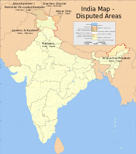
There are several disputed territories of India. A territorial dispute is a disagreement over the possession or control of land between two or more states or over the possession or control of land by a new state and occupying power after it has conquered the land from a former state no longer currently recognized by the new state. India now faces territorial issues with three of its neighbors – China, Nepal, and Pakistan. India has resolved its border disputes with Bangladesh and Sri Lanka and an undemarcated border with Bhutan, which included multiple irregularities. (citation needed) An agreement with the Republic of China (Taiwan) is pending.
Major disputes
Republic of China
The Republic of China (ROC), now based in Taiwan, is involved in territorial disputes with many governments bordering China. Due to the One-China policy, it has no formal diplomatic relations with any of these states. The ROC recognises neither the People's Republic of China (PRC) nor its border agreements or treaties with any other countries. Article 4 of the Constitution of the Republic of China states that "The territory of the Republic of China according to its existing national boundaries shall not be altered except by resolution of the National Assembly." Section 5 of Article 4 of the Additional Articles of the Constitution of the Republic of China now overrides this provision. Thus, the ROC is involved with all Sino-Indian border conflicts.
People's Republic of China
Aksai Chin
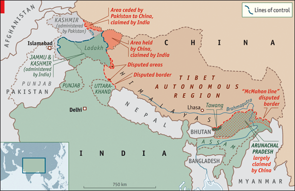
Aksai Chin, also Aksayqin, Akesaiqin or Akesai Qin (Hindi: अक्साई चिन, Urdu: اکسائی چن, Simplified Chinese: 阿克赛钦), is a disputed region located in the northwestern part of the Tibetan Plateau and immediately south of the western Kunlun Mountains. It is approximately 35,241 sq km in size, not including the Demchok region 500 sq km. It is entirely administered by the People's Republic of China as a part of Hotan County in the Hotan Prefecture of Xinjiang Autonomous Region. India considers it as a part of its state of Jammu and Kashmir. What little evidence existing suggests that the few true locals in Aksai Chin have Buddhist beliefs, although some Muslim Uyghurs may also live in the area because of the trade between Tibet and Xinjiang. India claims the area as a part of the Ladakh District of the state of Jammu and Kashmir; however, it has agreed to respect the Line of Actual Control.
Depsang Plains
The Depsang Plains are located on the border of the Indian state of Jammu and Kashmir and the disputed zone of Aksai Chin. The Chinese Army occupied most of the plains during its 1962 war with India; however, the Chinese retreated. The dispute remains unresolved.
Disputed areas located near Aksai Chin
Demchok 500 km2, Chumar, Kaurik, Shipki La, Nelang and Laptha. All of these are controlled by India i.e. Kaurik & Shipki La (in Himachal Pradesh), Nelang Valley with areas Leptha, Pulam Sumda and Sang etc.(in Uttarakhand) are areas claimed by China as a part of the Ngari Prefecture of the Zanda County of Tibet, except the Demchok parcel which is 70% with China and 30% with India which is called New Demchok. However China claims all of it. There is another area called Barahoti section area whose grazing fields are named disputed by China, which is also in the state of Uttarakhand and is controlled by India.
Trans-Karakoram Tract
The Trans-Karakoram Tract (Chinese: 喀喇昆仑走廊; pinyin: Kālǎkūnlún zǒuláng) is an area of nearly 5,800 km2/ 5180 km2 (2,239 sq mi) along both sides of the Shaksgam River, is entirely administered by the People's Republic of China as a part of Kargilik County and Taxkorgan Tajik Autonomous County in the Kashgar Prefecture of Xinjiang Autonomous Region, but was claimed by Pakistan until 1963. It is still claimed by India as part of the state of Jammu and Kashmir. Pakistan gave up its claim to the tract under a border agreement with China in 1963 with the proviso that the settlement was subject to the final solution of the Kashmir dispute.
Arunachal Pradesh
Arunachal Pradesh is a state of India created on 20 January 1972, located in the far northeast. It borders the states of Assam and Nagaland to the south, and shares international borders with Burma in the east, Bhutan in the west, and the China in the north. The majority of the territory is claimed by China as part of South Tibet. The northern border of Arunachal Pradesh reflects the McMahon Line, a 1914 treaty between the United Kingdom and the Tibetan government which was never accepted by the Chinese government, was also considered invalid by Tibetans due to unmet condition specified in the treaty,[1] and not broadly enforced by the Indian government until 1950. This territory is administered by India.[2][3]
Pakistan
Jammu and Kashmir, Azad Kashmir and Gilgit-Baltistan
These areas serve as the center the major dispute between Pakistan and India. Three wars have been fought between the two countries over Jammu and Kashmir, Azad Kashmir and Gilgit-Baltistan.[4]
Siachen Glacier
The Siachen Glacier 2,300 /2600 km2 including glacier area of about 700 km2 is located in the eastern Karakorams in the Himalayas at about 35.5°N 77.0°E, just east of the Actual Ground Position Line between India-Pakistan. India controls all of the Siachen Glacier itself, including all tributary glaciers. At 70 km (43 mi) long, it is the longest glacier in the Karakoram and second-longest in the world's non-polar areas.[5]
Saltoro Ridge
The Saltoro (also known as Saltoro Parvat or Saltoro Muztagh) mountain range is a subrange of the Karakoram Heights or of Saltoro Ridge. They are located in the heart of the Karakoram, on the southwest side of the Siachen Glacier.
They are claimed as part of Jammu and Kashmir by India and as part of Gilgit-Baltistan by Pakistan. In 1984, India assumed military control of the main peaks and passes of the range, with Pakistani forces into the glacial valleys just to the west. Hence, despite high peaks and dramatic climbing opportunities, they are little visited except by military forces due to the ongoing Siachen conflict.
Sir Creek
The Sir Creek is a 96 km (60 mi) strip of water disputed between India and Pakistan in the Rann of Kutch marshlands. Pakistan claims the line to follow the eastern shore of the estuary while India claims a center line (differing interpretations of paragraphs 9 and 10 of the Bombay Government Resolution of 1914 signed between then the Government of Sindh and Rao Maharaj of Kutch.
Thus affecting the maritime boundary negotiations in Arabian Sea waters. Before India's independence, the provincial region was a part of the Bombay Presidency of British India. After India's independence in 1947, Sindh became a part of Pakistan while Kutch remained a part of India, Indian Army and Pak Marines are deployed on both sides of the border.
Minor disputes
Myanmar
There are several small disputed land near Hollenphai village and between Moreh, Manipur and Namphalong, Tamu.
Nepal
Kalapani
Kalapani (कालापानी) is an area under territorial dispute in Darchula District, Nepal and Pithoragarh district of India, area 400 km2.
Although claimed by Nepal, Kalapani has been administered by India's Indo-Tibetan Border Police since the 1962 border war with China. The Sugauli Treaty signed by Nepal and British India in 1816 utilizes the Kali River as Nepal's western boundary with India. Subsequent maps drawn by British surveyors show the source of the boundary river at different places. This discrepancy in locating the source of the river led to boundary disputes between India and Nepal, with each country producing maps supporting their own claims. The Kalapani River runs through an area that includes a disputed area of about 400 km² around the source of the river although the exact size of the disputed area varies from source to source.
Susta
Susta is an area under territorial dispute currently in Tribenisusta, Nepal and near Nichlaul, Uttar Pradesh, India. The area under dispute totals over 14,000 hectares (140 km2).
Former Disputes
Sri Lanka
Border Issue Resolved
Kachchatheevu
Kachchatheevu or Katchatheevu or Kachativu (Tamil: கச்சத்தீவு Kaccatīvu) (Sinhala:කච්චතීවු) is an uninhabited island of 235 acres formerly claimed by both India and Sri Lanka. The two countries recognized Sri Lankan sovereignty over the island in 1974. It has a Catholic shrine and has been declared as a sacred area by the government of Sri Lanka. In 2001, the Tamil Nadu government called for the return of the island but Mahinda Rajapaksa, former Fisheries and Aquatic Resources Minister and president of Sri Lanka, declined. He said that, `It is impossible to give it back to them as it has been recognized by the international community as an integral part of our country since it was handed over by late Indira Gandhi.'
However, the Indian government has stated that "No territory belonging to India was ceded nor sovereignty relinquished since the area was in dispute and had never been demarcated" and that the dispute on the status of the island was settled in 1974 by an agreement, and both countries took into account historical evidence and legal aspects.[6]
Bangladesh
Border Issue Resolved
South Talpatti Island
South Talpatti (as it was known in Internationally) or Bangabandhu Island (as it was known as Awami politically in Bangladesh) was a small uninhabited offshore sandbar landform in the Bay of Bengal, off the coast of the Ganges-Brahmaputra Delta region. It emerged in the Bay of Bengal on the Bangladesh side of river that makes the boundary between India and Bangladesh in the aftermath of the Bhola cyclone in 1970, and disappeared before or during Cyclone Aila in 2009. In March 2010, Sugata Hazra of the School of Oceanographic Studies at Jadavpur University, Kolkatta, India, said that the island had disappeared and that sea level rise caused by climate change was a factor.[7]
Indo-Bangladesh enclaves, adverse possessions and unmarked boundaries
The enclaves or Chitmahal (Bengali: ছিটমহল) between India and Bangladesh border in the Indian state of West Bengal remained an issue between the two countries for a long time.
The enclaves were reputedly part of a high stake card or chess games centuries ago between two regional kings, the Maharaja of Cooch Behar and the Nawab of Rangpur and the result of a confused outcome of a treaty between the Kingdom of Koch Bihar and the Mughal Empire. After the partition of India in 1947, Cooch Behar district was merged with India and Rangpur went to then East Pakistan, which became Bangladesh in 1971. The prime ministers of India and Bangladesh signed a Land Boundary Agreement in 1974 to exchange enclaves and simplify the international border. In 1974 Bangladesh approved a proposed treaty, Land Boundary Agreement, to exchange all enclaves within each other's territories, but India did not ratified it. Another agreement was agreed upon in 2011 to exchange enclaves and adverse possessions. A revised version of the agreement was finally adopted by the two countries 41 years later, when the Parliament of India passed the 100th Amendment Act to the Indian Constitution on May 7, 2015.[8] Inside the main part of Bangladesh, there were 111 Indian enclaves (17,160.63 acres), while inside the main part of India, there were 51 Bangladeshi enclaves (7,110.02 acres). In respect of adverse possessions, India received 2,777.038 acres of land and transferred 2267.682 acres to Bangladesh. India ratified the agreement by constitutional amendment in May 2015.[9] Under this agreement, the enclave residents could continue to reside at their present location or move to the country of their choice.[10] [11] The adverse possession of Boraibari went to Bangladesh.[12] The unmarked borders between the nations were also finally solved regarding Daikhata-Dumabari, Muhurichar river island[13] and Pyrdiwah.[14]
See also
External links
References
- ↑ Tsering Shakya (1999). The Dragon in the Land of Snows: A History of Modern Tibet Since 1947. Columbia University Press. pp. 279–. ISBN 978-0-231-11814-9.
- ↑ Guo, Rongxing (2006). Territorial Disputes and Resource Management: A Global Handbook. Nova Publishers. p. 51. ISBN 9781600214455.
- ↑ Shurtleff, William; Aoyagi, Akiko (2010). History of Soybeans and Soyfoods in South Asia / Indian Subcontinent (1656-2010): Extensively Annotated Bibliography and Sourcebook (illustrated ed.). Soyinfo Center. p. 952. ISBN 9781928914310.
- ↑ https://www.worldatlas.com/articles/indo-pakistan-wars-1947-1965-1971-1999.html
- ↑ Operation Meghdoot
- ↑ Special Correspondent (2014-02-08). "Kachatheevu was not ceded to Sri Lanka & can't be retrieved – Government Of India". The Hindu. Retrieved 2014-02-18.
- ↑ Wade, Matt (March 25, 2010). "Rising sea level settles border dispute". The Sydney Morning Herald. Retrieved April 4, 2010.
- ↑ "The Constitution (119th Amendment) Bill, 2013" PRS India. Accessed 10 May 2015.
- ↑ India (2 December 2014). "Everything you need to know: Land swap in offing with Bangladesh to end disputes". The Indian Express. Retrieved 29 May 2015.
- ↑ Sougata Mukhopadhyay (7 September 2011). "India-Bangladesh sign pact on border demarcation". CNN-IBN. Retrieved 2011-09-20.
- ↑ Special Correspondent (2015-05-07). "Parliament passes historic land accord bill to redraw border with Bangladesh". The Times Of India. Retrieved 2015-05-07.
- ↑ MANOJ ANAND (2015-05-08). "Bangladesh land swap deal: AGP calls bandh, says PM Modi betrayed people". The Asian Age. Retrieved 2015-05-08.
- ↑ Shubhajit Roy (2014-12-02). "Everything you need to know: Land swap in offing with Bangladesh to end disputes". Indian Express. Retrieved 2014-12-02.
- ↑ Special correspondent (2015-05-06). "Meghalaya groups flay land-swap deal". Calcutta Telegraph. Retrieved 2014-05-06.