Parliamentary constituencies in Hertfordshire
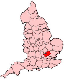
The county of Hertfordshire in England is divided into eleven Parliamentary constituencies. Each of the eleven elects a Member of Parliament (MP) to represent it at the United Kingdom (UK) Parliament in Westminster. As of the 2015 general election, all of Hertfordshire's eleven MPs are Conservatives. The county currently has two urban borough constituencies (BC) – Broxbourne and Watford – while the other nine are classed as more rural county constituencies (CC).
Hertfordshire has been represented in Parliament since 1290. The number of MPs and the geographic areas they have represented have changed considerably, with some of the bigger changes occurring in 1832, 1885, 1974, 1983 and 1997. Since the last constituency elections in 2005, some boundaries have been altered slightly. The present ones are based upon recommendations made by the Boundary Commission for England, and came into legal effect with the passing of the Parliamentary Constituencies (England) Order 2007.
Parliamentary history of Hertfordshire
Hertfordshire was first represented in the English parliament in the thirteenth century, during the reign of King Edward I.[1][2] Edward held a meeting of Parliament in the county in 1295.[3] By 1307, the county's representation in parliament consisted of two representatives, known as Knights of the Shire, who represented the county as a whole. In addition, the city of St Albans and borough of Hertford elected two representatives of their own.[1] Parliament's role evolved over the next five centuries, from a body existing primarily to advise the monarch on taxation, into a legislative body in its own right following the English Civil War. However, Hertfordshire's constituency makeup within it remained unchanged until 1852, when the constituency of St Albans was abolished. The next change came in the Redistribution of Seats Act 1885. The constituency of Hertfordshire itself was abolished, with the county represented by the constituencies of Hertford, the re-established St Albans, and the newly formed Watford and Hitchin.[4]
Following the Redistribution of Seats Act in 1885, Hertfordshire's Parliamentary boundaries remained the same until 1950. However, the demographics of voters in the county changed significantly, with four new towns being designated in the county in the three years from 1946–48.[5][6][7] Meanwhile the eligibility to vote was extended from men who held property of a high enough value, to universal suffrage for all adults over the age of 21, as a result of the Representation of the People Acts in 1918 and 1928.[8] In 1950 South West Hertfordshire was formed from part of the old Watford constituency, and for the following general election in 1955 East Hertfordshire was created from parts of Hitchin and Hertford. The next national boundary change affecting Hertfordshire came into effect for the February 1974 election. Four new constituencies were introduced, however three of these were replaced at the next national boundary change in 1983, as were Hitchin and East Hertfordshire. The 1983 boundary review saw the formation of Broxbourne, Hertford and Stortford, Hertsmere, Hitchin and Harpenden, Stevenage and North Hertfordshire, although the latter was replaced by North East Hertfordshire in 1997. The Boundary Commission for England decided not to change Hertfordshire's representation in Parliament for the 2010 election, although small boundary changes were made affecting eight of the county's eleven existing constituencies.[9]
Timeline
- Former constituency
- * Constituency for the United Kingdom general election, 2010
| Constituency | Years | ||||||||||||
|---|---|---|---|---|---|---|---|---|---|---|---|---|---|
| 1290–1298 | 1298–1307 | 1307–1852 | 1852–1885 | 1885–1918 | 1918–1950 | 1950–1955 | 1955-1965 | 1955–1974 | 1974–1983 | 1983–1997 | 1997–* | ||
| Hertfordshire[1] | 1290–1885 | ||||||||||||
| Hertford[1][10] | 1298–1974 | ||||||||||||
| St Albans[nb 1][1][10] | 1307–1852 | 1885–* | |||||||||||
| Watford[10] | 1885–* | ||||||||||||
| Hitchin[10] | 1885–1983 | ||||||||||||
| Hemel Hempstead[11] | 1918–1983 | 1997–* | |||||||||||
| Barnet | 1945-1965 | After 1965: Greater London administration begins, see constituencies in Greater London | |||||||||||
| South West Hertfordshire[12][13] | 1950–* | ||||||||||||
| East Hertfordshire[14] | 1955–1983 | ||||||||||||
| Hertford and Stevenage | 1974–1983 | ||||||||||||
| South Hertfordshire | 1974–1983 | ||||||||||||
| Welwyn Hatfield | 1974–* | ||||||||||||
| North Hertfordshire | 1983–1997 | ||||||||||||
| West Hertfordshire | 1983–1997 | ||||||||||||
| Broxbourne | 1983–* | ||||||||||||
| Hertford and Stortford | 1983–* | ||||||||||||
| Hertsmere | 1983–* | ||||||||||||
| Hitchin and Harpenden | 1997–* | ||||||||||||
| Stevenage | 1983–* | ||||||||||||
| North East Hertfordshire | 1997–* | ||||||||||||
Constituencies formerly sending two or three MPs
Following the 1832 Reform Act and the 1885 Acts, it became near-universal for constituencies to be represented by a single MP and finally universal on the abolition of the last university constituency. Before this, the House of Commons had far fewer constituencies, a large minority of which were represented by two, and rarely, more than two MPs. Those which were represented by several Members of Parliament are listed below, with the increase or reduction in representation being implemented at general elections held in those years.[1]
| Name | Year of formation | Year abolished | Number of MPs |
|---|---|---|---|
| Hertford | 1298[nb 2] | 1868 | 2 |
| Hertfordshire | 1290 | 1832 | 2 |
| 1832 | 1885 | 3 | |
| St Albans[nb 1] | 1307[nb 3] | 1852 | 2 |
Present Constituencies
Hertfordshire's Parliamentary boundaries were amended by the Boundary Commission for England's fourth report for the 1997 general election, and these boundaries were retained for the 2001 and 2005 elections. Each constituency is made up of a series of whole or partial local government wards, which elect individual councillors at English local elections. Nine constituencies are designated as county constituencies, while two are considered borough constituencies. County constituencies are generally larger and more rural, and therefore county constituency Parliamentary candidates are allowed to spend more per head than their borough counterparts.[15]
At the 2010 general election, the Conservative Party gained two seats from Labour. By holding their existing nine seats, they therefore returned an MP in every Hertfordshire constituency. The seat with the smallest majority was Watford, where Richard Harrington defeated Sal Brinton of the Liberal Democrats by 1,425 votes. The safest seat was Hertsmere, where James Clappison received 17,605 votes more than his nearest rival.
At the 2015 General Election, the Conservative Party held on to all 11 seats in Hertfordshire, with the Labour Party coming second in all constituencies with the exception of Broxbourne, where UKIP came second. The constituency with the smallest majority was Stevenage, where Stephen McPartland won by 4,955 votes. The constituency with the largest majority was South West Hertfordshire, which David Gauke won with a majority of 23,263.
† Conservative ‡ Labour ¤ Liberal Democrat ‡ UKIP
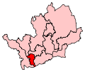
| Name[nb 4] | Electorate | Majority[nb 5] | Member of Parliament | Nearest opposition | Electoral wards[16][17] | Map | ||
|---|---|---|---|---|---|---|---|---|
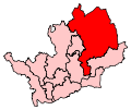
| Broxbourne BC | 73,502 | 15,792 | Charles Walker†[18] | Selina Norgrove‡ | Broxbourne Borough Council: Broxbourne, Bury Green, Cheshunt Central, Cheshunt North, Flamstead End, Goffs Oak, Hoddesdon North, Hoddesdon Town, Rosedale, Rye Park, Theobalds, Waltham Cross, Wormley & Turnford. Welwyn Hatfield Borough Council: Northaw. |
 | ||
| Hemel Hempstead CC | 74,415 | 9,445 | Michael Penning† | Mandi Tattershall‡ | Dacorum Borough Council: Adleyfield East, Adleyfield West, Apsley, Ashridge, Bennetts End, Boxmoor, Chaulden and Shrubhill, Corner Hall, Gadebridge, Grove Hill, Hemel Hempstead Central, Highfield and St Pauls, Kings Langley, Leverstock Green, Nash Mills, Warners End, Watling, Woodhall. | 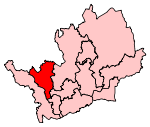 | ||
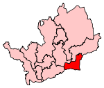
| Hertford and Stortford CC | 82,339 | 19,035 | Mark Prisk† | Katherine Chibah‡ | East Hertfordshire District Council: Bishop’s Stortford All Saints, Bishop’s Stortford Central, Bishop’s Stortford Meads, Bishop’s Stortford Silverleys, Bishop’s Stortford South, Great Amwell, Hertford Bengeo, Hertford Castle, Hertford Heath, Hertford Kingsmead, Hertford Rural South, Hertford Sele, Hunsdon, Much Hadham, Sawbridgeworth, Stanstead Abbots, Ware Chadwell, Ware Christchurch, Ware St Mary’s, Ware Trinity. | 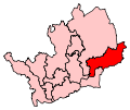 | ||
| Hertsmere CC | 73,561 | 16,951 | Oliver Dowden† | Fiona Smith‡ | Hertsmere Borough Council: Aldenham East, Aldenham West, Borehamwood Brookmeadow, Borehamwood Cowley Hill, Borehamwood Hillside, Borehamwood Kenilworth, Bushey Heath, Bushey North, Bushey Park, Bushey St James, Elstree, Potters Bar Furzefield, Potters Bar, Oakmere, Potters Bar Parkfield, Shenley. | 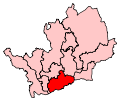 | ||
| Hitchin and Harpenden CC | 75,916 | 12,031 | Bim Afolami† | John Hayes‡ | North Hertfordshire District Council: Cadwell Graveley & Wymondley, Hitchin Bearton, Hitchin Highbury, Hitchin Oughton, Hitchin Priory, Hitchin Walsworth, Hitchwood, Hoo, Kimpton, Offa. St Albans City Council: Harpenden East, Harpenden North, Harpenden South, Harpenden West, Redbourn, Sandridge, Wheathampstead. |
 | ||
| North East Hertfordshire CC | 75,965 | 16,835 | Oliver Heald† | Doug Swanney‡ | East Hertfordshire District Council: Braughing, Buntingford, Hertford Rural North, Little Hadham, Mundens and Cottered, Puckeridge, Thundridge & Standon, Walkern, Watton-at-Stone. North Hertfordshire District Council: Arbury, Baldock East, Baldock Town, Ermine, Letchworth East, Letchworth Grange, Letchworth South East, Letchworth South West, Letchworth Wilbury, Royston Heath, Royston Meridian, Royston Palace, Weston and Sandon. |
 | ||
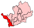
| South West Hertfordshire CC | 81,087 | 19,550 | David Gauke† | Robert Wakely‡ | Dacorum Borough Council: Aldbury and Wigginton, Berkhamsted Castle, Berkhamsted East, Berkhamsted West, Bovingdon Flaunden & Chipperfield, Northchurch, Tring Central, Tring East, Tring West. Three Rivers District Council: Ashridge, Chorleywood East, Chorleywood West, Croxley Green, Croxley Green North, Croxley Green South, Hayling, Maple Cross & Mill End, Moor Park & Eastbury, Northwick, Penn, Rickmansworth, Rickmansworth West, Sarratt. |
 | ||
| St Albans CC | 72,811 | 6,109 | Anne Main† | Daisy Cooper¤ | St Albans City Council: Ashley, Batchwood, Clarence, Colney Heath, Cunningham, London Colney, Marshalswick North, Marshalswick South, Park Street, St Peters, St Stephen, Sopwell, Verulam. Three Rivers District Council: Bedmond & Primrose Hill. |
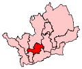 | ||
| Stevenage CC | 70,765 | 3,384 | Stephen McPartland† | Sharon Taylor‡ | East Hertfordshire District Council: Datchworth & Aston. North Hertfordshire District Council: Codicote, Knebworth. Stevenage Borough Council: Bandley Hill, Bedwell, Chells, Longmeadow, Manor, Martins Wood, Old Town, Pin Green, Roebuck, St Nicholas, Shephall, Symonds Green, Woodfield. |
 | ||
| Watford BC | 86,507 | 2,092 | Richard Harrington† | Chris Ostrowski‡ | Three Rivers District Council: Abbots Langley, Carpenders Park, Langleybury, Leavesden, Oxhey Hall. Watford Borough Council: Callowland, Central, Holywell, Leggatts, Meriden, Nascot, Oxhey, Park, Stanborough, Tudor, Vicarage, Woodside. |
 | ||
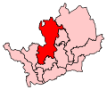
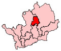
| Welwyn Hatfield CC | 72,888 | 7,369 | Grant Shapps† | Anawar Miah‡ | Welwyn Hatfield Borough Council: Brookmans Park and Little Heath, Haldens, Handside, Hatfield Central, Hatfield East, Hatfield North, Hatfield South, Hatfield West, Hollybush, Howlands, Panshanger, Peartree, Sherrards, Welham Green, Welwyn North, Welwyn South. | 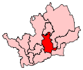 | ||
Results
| 1997 | 2001 | 2005 | 2010 | 2015 |
|---|---|---|---|---|
 |
|
 |
 |
|
| 2017 | ||||
|
Changes for the 2010 general election
In its fifth periodical report, the Boundary Commission for England recommended that the Hertfordshire constituencies used for the 1997, 2001 and 2005 general elections should be retained for the 2010 election. It did however suggest slight boundary changes to some constituencies, in an effort to reduce electoral disparity between constituencies. The recommendations, which became law with the Parliamentary Constituencies (England) Order 2007, also ensured that local government wards in Hertfordshire would no longer be split between two Parliamentary constituencies.[9][19]
Dash (—) signifies that there were no changes.
| No. on map | Constituency | Wards added from 2005 | Wards removed from 2005 | Pre-2010 Boundaries | Post-2010 Boundaries |
|---|---|---|---|---|---|
| 1 | Broxbourne | — | — | 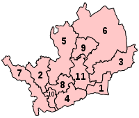 |
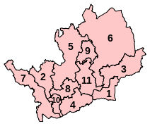 |
| 2 | Hemel Hempstead | — | Bovingdon Flaunden & Chipperfield | ||
| 3 | Hertford and Stortford | — | Hertford Rural South | ||
| 4 | Hertsmere | — | — | ||
| 5 | Hitchin and Harpenden | Cadwell Graveley & Wymondley, Sandridge | Letchworth Wilbury, Marshalswick North | ||
| 6 | North East Hertfordshire | Hertford Rural South, Walkern, Letchworth Wilbury | Cadwell Graveley & Wymondley | ||
| 7 | South West Hertfordshire | Bovingdon Flaunden & Chipperfield | — | ||
| 8 | St Albans | Marshalswick North, Bedmond & Primrose Hill | Sandridge | ||
| 9 | Stevenage | — | Walkern | ||
| 10 | Watford | — | Bedmond & Primrose Hill | ||
| 11 | Welwyn Hatfield | — | — | ||
Historical representation by party
1885 to 1945
Anti-Waste League Conservative Independent Liberal Silver Badge
| Constituency | 1885 | 1886 | 1892 | 1895 | 98 | 1900 | 04 | 1906 | Jan 10 | Dec 10 | 11 | 16 | 1918 | 19 | 20 | 21 | 1922 | 1923 | 1924 | 1929 | 1931 | 33 | 1935 | 37 | 41 | 43 | ||
|---|---|---|---|---|---|---|---|---|---|---|---|---|---|---|---|---|---|---|---|---|---|---|---|---|---|---|---|---|
| Hertford | A. Smith | E. Cecil | A. H. Smith | Rolleston | Billing | --> | Sueter | --> | ||||||||||||||||||||
| Hitchin | Dimsdale | Hudson | Bertram | Hillier | R. Cecil | Kindersley | Knebworth | Wilson | Berry | |||||||||||||||||||
| St Albans | J. W. Grimston | Gibbs | Slack | Carlile | Fremantle | J. Grimston | ||||||||||||||||||||||
| Watford | Halsey | Micklem | Ward | Herbert | Helmore | |||||||||||||||||||||||
| Hemel Hempstead | Talbot | J. Davidson | Dunn | J. Davidson | F. Davidson | |||||||||||||||||||||||
1945 to present
| Constituency | 1945 | 1950 | 1951 | 1955 | 1959 | 1964 | 1966 | 1970 | Feb 1974 | Oct 1974 | 1979 | 79 | 1983 | 1987 | 1992 | 1997 | 2001 | 2005 | 2010 | 2015 | 2017 |
|---|---|---|---|---|---|---|---|---|---|---|---|---|---|---|---|---|---|---|---|---|---|
| Barnet | Taylor | Maudling | Transferred to Greater London 1965 | ||||||||||||||||||
| Hemel Hempstead (1945-83, 97-) / West Hertfordshire
(1983) |
Davidson | Allason | Corbett | Lyell | Jones | McWalter | Penning | ||||||||||||||
| Hertford / & Stevenage (1974) / H & Stortford (1983) | Walker-Smith | Lindsay | Williams | Wells | Prisk | ||||||||||||||||
| Hitchin / North Hertfordshire
(1983) / NE Hertfordshire (1997) |
Jones | Fisher | Maddan | Williams | Stewart | Heald | |||||||||||||||
| St Albans | Dumpleton | Grimston | Goodhew | Lilley | Pollard | Main | |||||||||||||||
| Watford | Freeman | Farey-Jones | Tuck | Garel-Jones | Ward | Harrington | |||||||||||||||
| Hertfordshire SW | Longden | Dodsworth | Page | Gauke | |||||||||||||||||
| Hertfordshire E / Broxbourne (1983) | Walker-Smith | Roe | Walker | ||||||||||||||||||
| Hertfordshire South / Hertsmere (1983) | Parkinson | Clappison | Dowden | ||||||||||||||||||
| Welwyn and Hatfield | Lindsay | Hayman | Murphy | Evans | Johnson | Shapps | |||||||||||||||
| Stevenage | Wood | Follett | McPartland | ||||||||||||||||||
| Hitchin and Harpenden | Lilley | Afolami | |||||||||||||||||||
See also
Footnotes
- 1 2 St Albans was abolished in 1852, but re-established in 1885.
- ↑ Hertford began to send representatives to parliament in 1298, and became a permanent constituency in 1624.
- ↑ St Albans started sending members of parliament in 1307, and became a permanent constituency in 1554.
- ↑ BC denotes borough constituency, CC denotes county constituency.
- ↑ The majority is the number of votes the winning candidate receives more than their nearest rival.
References
- General
- "Boundary Commission for England: Fifth Periodical Report" (PDF). Boundary Commission for England. Crown Copyright. 2007. Archived from the original (PDF) on July 26, 2011. Retrieved 6 November 2009.
- Craig, Frederick Walter Scott (1972). Boundaries of Parliamentary Constituencies 1885–1972. Chichester, Sussex: Political Reference Publications. ISBN 0-900178-13-2.
- Robinson, Gwennah (1978). Barracuda Guide to County History, Vol III: Hertfordshire. Barracuda Books. ISBN 0-86023-030-9.
- Richard Hacker (13 February 2001). "Report on a local inquiry into the Parliamentary constituency boundaries for the county of Hertfordshire" (PDF). Archived from the original (PDF) on January 28, 2007. Retrieved 28 November 2009.
- Specific
- 1 2 3 4 5 6 David Boothroyd. "Parliamentary Constituencies in the unreformed House". David Boothroyd. Retrieved 9 November 2009.
- ↑ "Edward I 'Longshanks' (r. 1272–1307)". The Royal Household. Retrieved 12 November 2009.
- ↑ Robinson p31.
- ↑ "A parliamentary map of the British Isles showing the electoral divisions as described in the Redistribution of Seats Act, 1885". David Rumsey Historical Map Collection. Retrieved 12 November 2009.
- ↑ "No. 37785". The London Gazette. 12 November 1946. p. 5536.
- ↑ "No. 37875". The London Gazette. 7 February 1947. p. 664.
- ↑ "No. 38299". The London Gazette. 25 May 1948. p. 3136.
- ↑ "Women and the Vote". Parliamentary copyright. 13 November 2009. Archived from the original on May 20, 2009. Retrieved 26 November 2009.
- 1 2 Boundary Commission for England pp. 346–350.
- 1 2 3 4 "Historic maps". David Rumsey Historical Map Collection. Retrieved 28 November 2009.
- ↑ "Full text of "The Representation of the people act, 1918 : with explanatory notes"". Internet Archive. Retrieved 28 November 2009.
- ↑ "UK General Election results July 1945". politicsresources.net. Retrieved 29 November 2009.
- ↑ "UK General Election results February 1950". politicsresources.net. Retrieved 29 November 2009.
- ↑ "UK General Election results May 1955". politicsresources.net. Retrieved 29 November 2009.
- ↑ "Variation of election expenses limits for candidates at UK Parliamentary and local government elections" (PDF). The Electoral Commission. Retrieved 26 November 2009.
- ↑ "The Parliamentary Constituencies (England) Order 2007, page 4". Office of Public Sector Information. Crown copyright. 13 June 2007. Retrieved 7 November 2009.
- ↑ Boundary Commission for England pp. 1004–1007
- ↑ "Constituency:Broxbourne". BBC News. Retrieved 2 August 2010.
- ↑ "The Parliamentary Constituencies (England) Order 2007". Office of Public Sector Information. Crown copyright. 13 June 2007. Archived from the original on February 11, 2010. Retrieved 7 November 2009.