Linas, Essonne
| Linas | ||
|---|---|---|
| Commune | ||
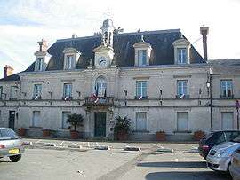 The town hall in Linas | ||
| ||
 Linas Location within Île-de-France region  Linas | ||
| Coordinates: 48°37′53″N 2°16′00″E / 48.6313°N 2.2668°ECoordinates: 48°37′53″N 2°16′00″E / 48.6313°N 2.2668°E | ||
| Country | France | |
| Region | Île-de-France | |
| Department | Essonne | |
| Arrondissement | Palaiseau | |
| Canton | Longjumeau | |
| Intercommunality | CA Paris-Saclay | |
| Government | ||
| • Mayor (2008–2014) | François Pelletant | |
| Area1 | 7.51 km2 (2.90 sq mi) | |
| Population (2006)2 | 6,373 | |
| • Density | 850/km2 (2,200/sq mi) | |
| Time zone | UTC+1 (CET) | |
| • Summer (DST) | UTC+2 (CEST) | |
| INSEE/Postal code | 91339 /91310 | |
| Elevation | 46–168 m (151–551 ft) | |
|
1 French Land Register data, which excludes lakes, ponds, glaciers > 1 km2 (0.386 sq mi or 247 acres) and river estuaries. 2 Population without double counting: residents of multiple communes (e.g., students and military personnel) only counted once. | ||
.svg.png)
Linas is a commune in the Essonne department in Île-de-France in northern France.
The famous motor racing circuit Autodrome de Linas-Montlhéry (often abbreviated as "Montlhéry") is located across the communes of Linas, Bruyères-le-Châtel and Ollainville.
Inhabitants of Linas are known as Linois.
See also
References
- INSEE
- Mayors of Essonne Association (in French)
External links
| Wikimedia Commons has media related to Linas. |
- Official website (in French)
- Mérimée database - Cultural heritage (in French)
- Land use (IAURIF) (in English)
This article is issued from
Wikipedia.
The text is licensed under Creative Commons - Attribution - Sharealike.
Additional terms may apply for the media files.