Limekiln, Pennsylvania
| Limekiln, Pennsylvania | |
|---|---|
| Unincorporated community | |
 Limekiln | |
| Coordinates: 40°20′36″N 75°48′18″W / 40.34333°N 75.80500°WCoordinates: 40°20′36″N 75°48′18″W / 40.34333°N 75.80500°W | |
| Country | United States |
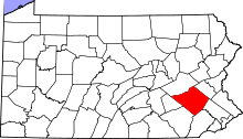
| State | Pennsylvania |
| County | Berks |
| Township | Exeter and Oley |
| Elevation | 289 ft (88 m) |
| Time zone | UTC-5 (Eastern (EST)) |
| • Summer (DST) | UTC-4 (EDT) |
| ZIP code | 19535 |
| Area code(s) | 610 and 484 |
| GNIS feature ID | 2488146[1] |
Limekiln is an unincorporated community in Berks County, Pennsylvania, United States. Limekiln is located at the intersection of Oley Turnpike Road and Limekiln Road on the border of Exeter and Oley townships.[2]
References
- ↑ "Limekiln". Geographic Names Information System. United States Geological Survey.
- ↑ Berks County, Pennsylvania Highway Map (PDF) (Map). PennDOT. 2012. Retrieved August 19, 2013.
This article is issued from
Wikipedia.
The text is licensed under Creative Commons - Attribution - Sharealike.
Additional terms may apply for the media files.