Cumru Township, Berks County, Pennsylvania
| Cumru Township | |
|---|---|
| Township | |
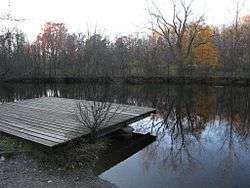 Nolde Forest Environmental Education Center | |
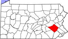
 Cumru Township Location of Cumru Township in Pennsylvania  Cumru Township Cumru Township (the US) | |
| Coordinates: 40°18′N 75°57′W / 40.300°N 75.950°WCoordinates: 40°18′N 75°57′W / 40.300°N 75.950°W | |
| Country | United States |
| State | Pennsylvania |
| County | Berks |
| Area[1] | |
| • Total | 21.18 sq mi (54.85 km2) |
| • Land | 20.90 sq mi (54.14 km2) |
| • Water | 0.28 sq mi (0.72 km2) |
| Elevation | 459 ft (140 m) |
| Population (2010) | |
| • Total | 15,147 |
| • Estimate (2016)[2] | 15,334 |
| • Density | 733.61/sq mi (283.25/km2) |
| Time zone | UTC-5 (EST) |
| • Summer (DST) | UTC-4 (EDT) |
| Area code(s) | 610 |
| FIPS code | 42-011-17720 |
| Website |
www |
Cumru Township (pronounced "KUM-roo") is a township in Berks County, Pennsylvania, United States. The population was 15,147 at the 2010 census. Nolde Forest Environmental Education Center, a Pennsylvania state park, is in Cumru Township.
History
The township was so named by Welsh settlers, after Cymru, meaning Wales in the Welsh language.[3]
Ridgewood Farm was listed on the National Register of Historic Places in 1992.[4]
Geography
According to the United States Census Bureau, the township has a total area of 20.9 square miles (54 km2), of which, 20.7 square miles (54 km2) of it is land and 0.2 square miles (0.52 km2) of it (1.15%) is water. It is drained by the Schuylkill River which forms its natural NE boundary.
Adjacent townships
- Lower Alsace Township (northeast)
- Exeter Township (northeast)
- Robeson Township (east)
- Brecknock Township (south)
- Spring Township (west)
Adjacent city and boroughs
- Reading (north)
- Wyomissing (north)
- Shillington (north)
- Kenhorst (north)
- Mohnton (surrounded)
Its unincorporated communities include Angelica, Clover Park, Colonial Hills, Farview, Flying Hills, Freemanville, Gouglersville, Grill, Pennwyn, Ridge Park, and Ridgewood.
Demographics
| Historical population | |||
|---|---|---|---|
| Census | Pop. | %± | |
| 2000 | 13,816 | — | |
| 2010 | 15,147 | 9.6% | |
| Est. 2016 | 15,334 | [2] | 1.2% |
| Source: US Census Bureau | |||
As of the census[5] of 2000, there were 13,816 people, 5,941 households, and 3,808 families residing in the township. The population density was 668.0 people per square mile (257.9/km²). There were 6,127 housing units at an average density of 296.3/sq mi (114.4/km²). The racial makeup of the township was 93.84% White, 1.92% African American, 0.06% Native American, 1.88% Asian, 0.04% Pacific Islander, 1.27% from other races, and 0.99% from two or more races. Hispanic or Latino of any race were 2.82% of the population.
There were 5,941 households, out of which 24.1% had children under the age of 18 living with them, 54.6% were married couples living together, 6.8% had a female householder with no husband present, and 35.9% were non-families. 28.8% of all households were made up of individuals, and 12.5% had someone living alone who was 65 years of age or older. The average household size was 2.27 and the average family size was 2.81.
In the township the population was spread out, with 19.0% under the age of 18, 7.1% from 18 to 24, 26.9% from 25 to 44, 27.4% from 45 to 64, and 19.7% who were 65 years of age or older. The median age was 43 years. For every 100 females, there were 92.2 males. For every 100 females age 18 and over, there were 89.5 males.
The median income for a household in the township was $50,103, and the median income for a family was $58,161. Males had a median income of $42,108 versus $27,701 for females. The per capita income for the township was $28,996. About 1.4% of families and 4.4% of the population were below the poverty line, including 3.1% of those under age 18 and 5.1% of those age 65 or over.
Transportation
The township's numbered routes are Pennsylvania Route 10, Interstate 176, U.S. Route 222, U.S. Route 222 Business (Lancaster Pike), U.S. Route 422, Pennsylvania Route 625, and Pennsylvania Route 724.
References
- ↑ "2016 U.S. Gazetteer Files". United States Census Bureau. Retrieved Aug 13, 2017.
- 1 2 "Population and Housing Unit Estimates". Retrieved June 9, 2017.
- ↑ "Local school children to hear history of Berks and deeds of noted citizens". Reading Eagle. Mar 6, 1927. p. 5. Retrieved 2 December 2015.
- ↑ National Park Service (2010-07-09). "National Register Information System". National Register of Historic Places. National Park Service.
- ↑ "American FactFinder". United States Census Bureau. Archived from the original on 2013-09-11. Retrieved 2008-01-31.
External links
| Wikimedia Commons has media related to Cumru Township, Berks County, Pennsylvania. |