Lichfield District
| Lichfield District | ||
|---|---|---|
| Non-metropolitan district | ||
| ||
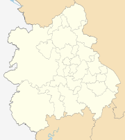
 Shown within Staffordshire | ||
| Sovereign state | United Kingdom | |
| Constituent country | England | |
| Region | West Midlands | |
| Ceremonial county | Staffordshire | |
| Admin HQ | Lichfield | |
| Created | 1 April 1974 | |
| Government | ||
| • Type | Non-metropolitan district | |
| • Leader | Mike Wilcox | |
| • Council | Conservative | |
| • MPs: | Christopher Pincher C | |
| Area | ||
| • Total | 127.9 sq mi (331.3 km2) | |
| Population (mid-2017 est.) | ||
| • Total | 103,500 (Ranked 230th) | |
| Time zone | UTC0 (GMT) | |
| • Summer (DST) | UTC+1 (BST) | |
| Post Code | WS7, 13-14 | |
| Area code(s) | 01543 | |
| Website | http://www.lichfielddc.gov.uk/ | |
Lichfield (UK: /ˈlɪtʃˌfiːld/[1]) is a local government district in Staffordshire, England. It is administered by Lichfield District Council, based in Lichfield.
The dignity and privileges of the City of Lichfield are vested in the parish council of the 14 km² Lichfield civil parish. The non-metropolitan district of Lichfield covers nearly 25 times this area and its local authority is Lichfield District Council.
The district was formed on 1 April 1974, under the Local Government Act 1972, by a merger of the existing City of Lichfield with most of the Lichfield Rural District.
The town of Burntwood also makes up a major part of the Lichfield district.
Etymology
Legend has it that a thousand Christians were martyred in Lichfield around AD 300, during the reign of the Roman Emperor Diocletian, and that the name 'Lichfield' actually means 'field of the dead' (see Lich). There is however, no evidence to support this legend.[2] At Wall, 3 miles (5 km) to the south of the present city, there was a Romano-British village called Letocetum from the British (Celtic) for "grey wood", from which the first half of the name Lichfield is derived.[3] The second part of the name is derived from the Old English "feld", meaning 'open country'. In that sense 'Lichfield' would be 'common pasture in grey wood', 'grey' perhaps referring to varieties of tree prominent in the landscape, such as ash and elm.[4]
Politics
Elections to the borough council are held every four years, with all of the 56 seats on the council being elected. After being under Labour from the 1995 election, the Conservative party gained a majority at the 1999 election and have retained control ever since.
Following the United Kingdom local elections, 2011 and subsequent by-elections,[5] the political composition of Lichfield council is as follows:
| Year | Conservative | Labour | Liberal Democrat |
|---|---|---|---|
| 2014 | 45 | 10 | 1 |
Demographics
According to 2008 estimates, the population of Lichfield district is 97,900. At the time of the 2001 UK Census, Lichfield district’s population was 93,232. The figures below are also from the 2001 UK Census.
50.89% of the population was female, leaving 49.11% of the population being male.[6]
Christians made up 80.44% of the population, with 11.95% of the population having no religion, 1.05% being from other religions and 6.56% who didn’t state a religion.[6]
96.57% of the population was White British, 0.70% White Irish, 0.87% White Other, 0.53% Mixed Race, 0.78% Asian, 0.25% Black and 0.29% Chinese. 2.84% of the population was born outside of the United Kingdom.[7]
Settlements within the district
- Alrewas, Armitage
- Blithbury, Burntwood
- Chase Terrace, Chasetown, Chorley, Clifton Campville, Colton, Comberford, Croxall, Curborough
- Drayton Bassett
- Edingale, Elford, Elmhurst
- Farewell, Fazeley, Fisherwick, Fradley
- Gentleshaw
- Hademore, Hammerwich, Hamstall Ridware, Handsacre, Harlaston, Haunton, Hill Ridware, Hilliards Cross, Hints, Hopwas
- Kings Bromley
- Lichfield, Little Aston, Little Hay, Longdon
- Mavesyn Ridware, Mile Oak
- Orgreave
- Pipe Ridware
- Rileyhill
- Shenstone, Stockwell Heath, Stonnall, Streethay, Swinfen
- Thorpe Constantine
- Upper Longdon
- Wall, Weeford, Whittington, Wigginton
Places of interest

Adventure and excitement

- Curborough Sprint Course - A premier motorsport venue for speed sprinting against the clock.
Arts and entertainment

History and heritage

- Cathedral Close - Surrounding the Cathedral with its many fine buildings is one of the most unspoilt in the country.


- Milley's Hospital - Located on Beacon Street, it dates back to 1504 and was a women's hospital.
- The Franciscan Friary - The ruins of the former Friary in Lichfield, now classed as a Scheduled Ancient Monument.
- Lichfield Clock Tower - A Grade II listed 19th century clock tower, located south of Festival Gardens.


- The Market Square - In the centre of the city of Lichfield, the square contains two statues, one of Samuel Johnson overlooking the house in which he was born, and one of his great friend and biographer, James Boswell.
Parks and the great outdoors
- Beacon Park - An 81-acre (33 ha) public park in the centre of the city, used for many sporting and recreational activities.
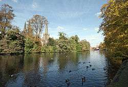
- Minster Pool & Stowe Pool - The two lakes occupying 16 acres in the heart of Lichfield, Stowe Pool is designated a SSSI site as it is home to native White-Clawed Crayfish.
- National Memorial Arboretum - 4 miles (6 km) north east of the city in Alrewas, the arboretum is a national site of remembrance and contains many memorials to the armed services.
- Chasewater Country Park - A country park including a 3-square-kilometre reservoir which hosts a variety of activities including water skiing, sailing, angling and bird watching. The Chasewater habitat also supports several rare plant and animal species.
- Chasewater Railway - A 2 mile long, former colliery railway running round the shores of Chasewater.
- Garden of Remembrance - Located next to Lichfield Cathedral and Minster Pool, the garden was opened in 1920 to commemorate soldiers lost in the First World War.
- Gentleshaw Common - A Site of Special Scientific Interest that contains rare species of heathland plants.
- Fradley Junction - A canal junction between Fradley and Alrewas popular with gongoozlers and other visitors. Fradley Pool Nature Reserve is adjacent to the junction.
- Prince's Park - Located in Burntwood, it is featured in the Guinness Book of Records for being the smallest park in the United Kingdom.
Shopping and retail
- Three Spires Shopping Centre - The principle shopping area in the heart of Lichfield with over 40 top name stores and 750 parking spaces.
- Heart of the Country Shopping Village - Individual shops and distinctive restaurants, a welcome alternative to high street shopping.
Plans have been approved for Friarsgate, a new £100 million shopping and leisure complex opposite Lichfield City Station. The police station, bus station, Ford garage and multi-storey car park will be demolished to make way for new retail space and leisure facilities consisting of a flagship department store, six-screen cinema, hotel, 37 individual shops, 56 apartments and over 700 car parking spaces.
Staffordshire Hoard Discovery
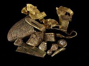
Discovered in a field near the village of Hammerwich, near Lichfield City, in Staffordshire, on 5 July 2009, the Staffordshire Hoard is the largest hoard of Anglo-Saxon gold and silver metalwork ever found. It consists of nearly 4,000 items that are nearly all martial in character.[8] The artefacts have tentatively been dated to the 7th or 8th centuries, placing the origin of the items in the time of the Kingdom of Mercia.
The hoard was valued at £3.285 million, and was purchased by the Birmingham Museum & Art Gallery and the Potteries Museum & Art Gallery where items from the hoard are displayed.
See also
External links
| Wikimedia Commons has media related to Lichfield. |
References
- ↑ "Lichfield". Collins Dictionary. n.d. Retrieved 23 September 2014.
- ↑ "Explaining the origin of the 'field of the dead' legend". British History Online. Retrieved 20 November 2008.
- ↑ "Lichfield". Key to English Place Names. Institute for Name Studies, University of Nottingham. Retrieved 12 May 2012.
- ↑ [From: 'Lichfield: The place and street names, population and boundaries ', A History of the County of Stafford: Volume 14: Lichfield (1990), pp. 37-42. URL: http://www.british-history.ac.uk/report.aspx?compid=42340 Date accessed: 20 July 2009.]
- ↑ http://www.lichfielddc.gov.uk/info/100004/council_and_democracy/1751/councillor_vacancy_in_chadsmead_ward
- 1 2 "Lichfield District Area Statistics". 2001 UK Census.
- ↑ "Lichfield District Ethnic Group Statistics". 2001 UK Census.
- ↑ "The Find". Staffordshire Hoard. Retrieved 14 June 2011.
Coordinates: 52°40′51″N 1°49′39″W / 52.6809°N 1.8276°W
| Unitary authorities | |
|---|---|
| Boroughs or districts | |
| Major settlements | |
| Rivers | |
| Canals | |
| Topics | |