River Dane
| River Dane | |
| River | |
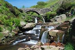 The Dane at Three Shire Heads | |
| Country | England |
|---|---|
| Counties | Staffordshire, Cheshire, Derbyshire |
| Tributaries | |
| - left | River Croco, River Wheelock |
| Source | |
| - location | Axe Edge Moor |
| Mouth | |
| - location | Confluence with River Weaver |
The River Dane is a tributary of the River Weaver that originates in the Peak District area of England. It forms the border between first Cheshire and Derbyshire on the west and east, and then between Cheshire and Staffordshire where it then flows north-west through Cheshire before meeting the Weaver near Northwich.
The river rises close to the source of the River Goyt just to the south west of Buxton, on Axe Edge Moor. Flowing southwest, it forms county borders for around 10 miles (16 km) before flowing west through Congleton and past Holmes Chapel. The point on the river where the three counties meet, at Panniers' Pool Bridge, is called Three Shire Heads (sometimes Three Shires Head).[1] Passing just north of Middlewich, it merges first with the River Croco near the site of the old Roman fort in Harbutt's Field, and then with the River Wheelock near the aqueduct carrying the Trent and Mersey Canal, and runs the remaining 5 miles (8 km) north to Northwich where it flows into the River Weaver.
The name of the river (earlier Daven) is probably from the Old Welsh dafn, meaning a "drop or trickle", implying a slow-moving river.[2]
The route of the Dane is followed as closely as possible by the Dane Valley Way, a 48-mile (77 km) walking route from Buxton to Northwich.[3]
Although the main river is part of the Mersey catchment and flows into the Irish Sea, a portion of the water can be diverted via canal feeders into Rudyard Lake and subsequently the Caldon Canal. This water discharges eventually into the River Trent and ultimately into the North Sea, having crossed the English watershed.[3]
Tributaries
- Gad Brook (R)
- Eldersbriar Brook (L)
- Puddlinglake Brook (R)
- River Wheelock (L)
- Hoggins Brook (L)
- Fowle Brook (L)
- River Croco (L)
- Sanderson's Brook (L)
- Small Brook (L)
- Sanderson's Brook (L)
- Swettenham Brook
- Midge Brook (Ls)
- Chapel Brook (R)
- Dighill Brook (R)
- Chapel Brook (R)
- Clonter Brook (Rs)
- Midge Brook (Ls)
- Loach Brook
- Dairy Brook (L)
- The Howty (L)
- Dane in Shaw Brook (L)
- Biddulph Brook
- Timbers Brook (R)
- Cow Brook (R)
- Ravensclough Brook (L)
- Shell Brook (R)
- Clough Brook (R)
- Highmoor Brook (R)
- Rabb Brook (R)
- Oaken Brook (R)
- Cumberland Brook (L)
- Yarnshaw Brook (L)
- Correction Brook (L)
- Tor Brook (R)
- Highmoor Brook (R)
- Black Brook
- Flash Brook (L)
- Far Brook (R)
- Robins Brook (R)
- Three Shires Brook (L)
See also
References
- ↑ Walks in the UK Peak District - Axe Edge Moor, Buxton's coal mining district
- ↑ Watts, Victor, ed. (2010), "Dane", The Cambridge Dictionary of English Place-Names, Cambridge University Press
- 1 2 "Dane Valley Way". Long Distance Walkers Association. Retrieved 20 September 2018.