Lenapehoking
Lenapehoking is a term for the lands historically inhabited by the Native American people known as the Lenape (named the Delaware people or Delaware Nation by early European settlers) in what is now the Northeastern United States. Though it is sometimes said to be a word in the Delaware languages for this area, like much of the toponymy involving languages in the Algonquian linguistic group, there is some confusion about the meaning and history of the name. Much of this land is now heavily urbanized and suburbanized. Although the Delaware generally proved to be good neighbors to the colonies of New Sweden and New Netherlands,[1] by the early 18th century, English settlers had depopulated or ruthlessly displaced most surviving tribal peoples.[1]
Linguistic controversy
There is no universal agreement among scholars regarding the autonym of Lenape territory. Some believe the area the Lenape inhabited was called 'Scheyichbi,' or "the place bordering the ocean". According to some people, the Lenape called this territory "Lenapehoking" (lənape haki-nk), meaning 'in the land of the Lenape'. This assertion has gained widespread acceptance and is found widely in recent literature on the Lenape, including in the websites of purported Lenape people.
Range and bounds
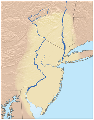
At the time of the arrival of the Europeans in the 16th and 17th centuries, the Lenape homeland ranged along the Atlantic's coast from western Connecticut to Delaware, which generally encompassed the territory adjacent to the Delaware and lower Hudson river valleys, as well the hill-and-ridge dominated territory between them. Relatives of the Algonquian Amerindians whose territories ranged along the entire coast from beyond the Saint Lawrence River in today's Canada, and the tribes throughout all of New England,[1] down into northern South Carolina,[1] the Delaware Confederation[lower-alpha 1] stretched from the southern shores of modern-day Delaware along the Atlantic seaboard into western Long Island and Connecticut, then extended westwards across the Hudson water gap into the eastern Catskills part of the Appalachians range around the headwaters of the Delaware River and along both banks of its basin down to the mouth of the Lehigh.
Inland, the tribe had to deal with the fierce and territorial Susquehannocks; the Delawares' territory has generally been plotted with boundaries[lower-alpha 2] along mountain ridges[lower-alpha 3] topped by the drainage divides between the right bank tributaries of the Delaware River on the east—and on the west and south—the left bank tributaries of the Susquehanna and Lehigh Rivers; bounds which included the Catskills, northern parts of eastern Pennsylvania down through the entire Poconos along the left bank Lehigh River. The Schuylkill River and its mouth (future Philadelphia area counties) or right bank Lehigh was contested hunting grounds, generally shared with the Susquehannock and the occasional visit by a related Potomac tribe when there wasn't active tribal warfare. The greater Philadelphia area was known to host European to Indian contacts from the Dutch traders contacts with the Susquehanna (1600), English traders (1602), and both tribes with New Netherlands traders after 1610
Along the left bank Delaware valley, the territory extended to all of present-day New Jersey, and the southern counties of New York State, including Rockland, Orange, Westchester, and Putnam Counties, Nassau County, and the five boroughs of New York City.[lower-alpha 4]
Today's ranges
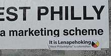
Today, some Native Americans, but not limited to the Lenape (Delaware) tribes, live in the Northeast Corridor or Eastern Seaboard. Many of them first arrived in the 1920s to 1960s from the Iroquois Confederacy employed as skyscraper construction workers, where they were nicknamed "Mohawks" and played an important role in building the skyline of Philadelphia and New York City. In the University City section of West Philadelphia, there has been some political activity by Urban Indian residents of the area, who adapted the namesake Lenapehoking to where they live.
Lenape place names
Lenape place names within the region included:
- Manhattan
- Manhattan is derived from Manna-hata, a Dutch version of a Lenape place-name.
The name Manhattan derives from the word Manna-hata, as written in the 1609 logbook of Robert Juet, an officer on Henry Hudson's yacht Halve Maen (Half Moon).[2] A 1610 map depicts the name Manahata twice, on both the west and east sides of the Mauritius River (later named the North River, and now called the Hudson River). The word Manhattan has been translated as "island of many hills" from the Lenape language.[3] The Encyclopedia of New York City offers other derivations, including from the Munsee dialect of Lenape: manahachtanienk ("place of general inebriation"), manahatouh ("place where timber is procured for bows and arrows"), or menatay ("island").[4]
- Sapokanikan - habitation site and cultivated area by the cove on the Hudson River at present day Gansevoort Street, Greenwich Village.
- Nechtanc - habitation site along the East River site of Jacob Van Corlaer's plantation at Corlaer's Hook, near the present location of the Williamsburg Bridge, in the part of the Lower East Side that is near Chinatown.
- Staten Island
- Aquehonga - name for Staten Island
- Manacknong - name for Staten Island
- Shawkopoke - habitation site and cultivated area along Great Kills Harbor
- Brooklyn
- Nayack or Wichquawanck - habitation in Bay Ridge near the present location of the Verrazano Narrows Bridge
- Gowanus Canal - originally named by early settlers as "Gowanes Creek" after Gouwane, sachem of the local Lenape tribe called the Canarsee, who lived and farmed along the shores of the creek.[5]
- Sassian - habitation site in present Red Hook
- Queens
- Rockland County, New York
- Monsey - from the name of the Munsees, northern branch of the Lenapes
- New Jersey
- Absecon - meaning: "place of swans"[8]
- Assunpink Creek - meaning: "Stony Creek"[8]
- Communipaw (in downtown Jersey City) - "riverside landing place"[8]
- Cushetunk - "place of hogs"[8]
- Hackensack - "stream flowing into another on a plain/ in a swamp/ in a lowland"[8]
- Hoboken - "where pipes are traded"
- Hohokus - "red cedars"[8]
- Hopatcong - "pipe stone" (NOT "honey waters of many coves" as early 20th-century boosters would have it)[9]
- Kittatinny - "great hill" or "endless mountain"
- Mahwah - "meeting place"
- Manahawkin - "place where there is good land"
- Manalapan - municipality's name is said to have come from Lenape and is said to mean "land of good bread"
- Mantoloking - said to be either "frog ground", "sandy place" or "land of sunsets"
- Manasquan - "Man-A-Squaw-Han", meaning "stream of the island of squaws"
- Mantua - said to have come from the "Munsees", North Jersey Lenapes, but the township is in South Jersey.[8]
- Matawan - "hill on either side"[8]
- Metuchen - "dry firewood"[8]
- Minisink - "from the rocky land", is the old name for the Munsee, and the name of an ancient Lenape trade route that ran along a good part of what is now US Highway 46 in Northern New Jersey
- Musconetcong
- Netcong - Abbreviation of "Musconetcong".
- Parsippany - original form was "parsipanong", which means "the place where the river winds through the valley"[8]
- Passaic - "valley" or "river flowing through a valley"[8]
- Peapack - "place of water roots"[8]
- Raritan - original form was Naraticong - may have meant "river behind the island" or "forked river".[8]
- Scheyichbi. Meaning of name varies.[8] notes two possible meanings: the land that the Lenapes called their country, or "land of the shell money (wampum)".[8]
- Secaucus - "black snakes".[8]
- Weehawken - "place of gulls".[8]
- Pennsylvania
- Aquashicola Creek - derived from the Lenape, meaning "where we fish with the bushnet."[10]
- Cacoosing Creek- derived from the Lenape word "kukhus", meaning "owl"[11]
- Buckwampum Mountain - located in eastern Springfield Township, Bucks County, means "a round bog".[12]
- Catasauqua - "thirsty ground"[13]
- Catawissa - "growing fat"[14]
- Chinquapin - The name is taken from a small nut-bearing tree or shrub, resembling the American Chestnut.
- Cocalico- "where the snakes collect in dens to pass the winter"[15]
- Cohocksink Creek - from a Lenape word for "pine lands."[16]
- Cohoquinoque Creek- derived from a Lenni-Lenape word for "the grove of long pine trees."
- Connoquenessing - "a long way straight"[17]
- Conococheague Creek - "water of many turns"
- Conodoguinet Creek - "A Long Way with Many Bends"
- Conshohocken - original form "Gueno-sheiki-hacking", meaning pleasant valley.[18]
- Hokendauqua Creek - From Lenape words: Haki, or land, and undoech-wen, or to come for some purpose, Meaning: "Searching for land"
- Kingsessing - "a place where there is a meadow"
- Kittatinny - "great mountain"
- Karakung - "clay creek"
- Lahaska - derived from "Lahaskeke" meaning "the place of much writing,"[12]
- Lackawanna - "forks of a stream"
- Lehigh County - from Lenape word "Lechauwekink" meaning "at the forks of a path or stream"
- Lycoming - "great stream"[19]
- Macungie - derived from Maguntsche, meaning "bear swamp" or "feeding place of the Bears."
- Mahoning Creek - from Lenape word: Mahonink, meaning: "at the mineral lick" referring to a place frequented by deer, elk and other animals
- Manatawny Creek - "place where we drank"[20]
- Manayunk - "place where we go to drink"[18]
- Mauch Chunk Creek - from Lenape word: "Machk-tschunk" meaning: "at the bear mountain"[21]
- Maxatawny - from Lenape word Machksit-hanne meaning: "bear path stream"[21]
- Monocacy - from Lenape word Menagassi meaning: "stream with several large bends"[21]
- Moselem - "trout stream"[22]
- Moshannon Creek - derived from "Moss-Hanne", meaning "moose stream"[23]
- Moyamensing - place of judgment, located in the south part of Philadelphia
- Muckinipattis Creek - "deep running water"[24]
- Neshaminy Creek - from Lenape word: "Nischam-hanne" meaning: "two streams" or "double stream"[12]
- Nesquehoning Creek - from Lenape word: Neska-honi, meaning: "black mineral lick"[21]
- Nittany - "single mountain"[25]
- Nockamixon Township - from Lenape word: "Nochanichsink" meaning: "where there are three houses"[12]
- Ockanickon Scout Reservation - named after a Lenape chief who assisted William Penn in the exploration of the Bucks County area.[26]
- Okehocking Historic District - an 18th-century Indian Land Grant by William Pennto the Okehocking band of Lenape (Delaware) Indians in 1703.[27]
- Ontelaunee - little daughter of a great mother[28]
- Passyunk - a Philadelphia neighborhood and former township named for a Lenape village (compare to Passaic, New Jersey)[29]
- Paxtang - "where the waters stand"[30]
- Paunacussing Creek - means "where the powder was given to us."[12]
- Pennypack Creek - "downward-flowing water" - a creek in and near Philadelphia.[31]
- Perkasie - derived from Poekskossing, meaning "where the hickory nuts were cracked."[12]
- Perkiomen Creek - derived from "Pakihmomink" meaning "where the cranberries grow" - a creek in central Montgomery County, Pennsylvania.[12]
- Pocono - from Lenape word Poco-hanne "a stream between mountains"[21]
- Poquessing Creek - "place of the mice"[12]
- Punxsutawney - "Punkwsutènay" meaning "town of the sandflies"
- Saucon Creek - from Lenape word Sacunk meaning: "the mouth of a stream"[21]
- Shackamaxon - which means place of the council and is on the site of Penn Treaty Park in Philadelphia.[32]
- Skippack - from Lenape word Skappeu-hacki meaning: "wet land"[21]
- Susquehanna River - from (Lenape: Siskëwahane) "mile wide, foot deep"
- Tamaqua - from Lenape word: "Tamaqua" meaning: "beaver"[21]
- Tatamy - from Lenape name: Chief Moses Tatamy who lived in the region and died in 1761
- Tohickon Creek - "the stream over which we pass by means of a bridge of drift-wood" or simply "deer-bone--creek."[12]
- Towamencin - a township in Montgomery County, Pennsylvania, means "Poplar Tree" [33]
- Towamensing- "fording place at the falls"[21]
- Tulpehocken - "land of turtles", the name of a creek and a SEPTA train station and street in Philadelphia[34]
- Unami Creek - From Lenape word: Unami meaning "person from down river"[21]
- Wissahickon - "yellow stream" or "catfish stream" - a creek in and near Philadelphia.[35]
- Wyomissing - meaning "the land of flats" - a borough in Berks County Pennsylvania[21]
- Youghiogheny - "four streams" or "winding stream"
See also
Notes
- ↑ The Delaware peoples organized themselves into divisions. Tribal government was through the appointment of Sachems (chieftains) by the tribal matriarchs. A Sachem could also come about by merit, these were generally earned in acts of warfare.[1]
- ↑ Natural barriers to foot travel predominate defining the limits of cultures without written languages. In tribal North America, between rivals and deadly enemies, hunting ranges devoid of permanent settlements were the rule, but summer hunting or fishing camps with temporary shelters were also common—as were the peaceful visits and trading along people historians have incorrectly painted as eternally at war. Games and competitions, trade and social visits were far more common, even among supposed hated enemies than were periods of warfare.[1]
- ↑ Given the foot-and-birch-bark-canoe-travel technology of the era, anyone familiar with hunting in the Appalachian topographies, would find this eminently sensible. Topping any ridge away from a major stream would be a climb only be undertaken if crossing into another drainage catchment. Canoe navigable streams occur only after waters have had time to gather and possibly dam up in broader valleys carved by glaciers or spring floods and beaver dams, so are well away from the boundaries marked logically atop drainage divides and their characteristic small steep rock strewn streams that were difficult to walk, and impassible by valuable & fragile birch bark canoes. The implication is the drainage divide areas, were little visited and unpopulated areas between tribes since they were difficult to travel into, across, or out of—the reader is reminded the nature of the forests in North America ran to tree sizes we rarely see today in isolated specimens with trunks starting over two feet in diameter. Only where a mountain pass, such as the gaps of the Allegheny was part of the goal, were such remote areas commonly visited before the extensive trapping and hunting beginning with the Beaver Wars period.
- ↑ Along with New York City, Newark, Trenton, Princeton, Philadelphia, Wilmington, Delaware, Atlantic City, and numerous other urban and suburban areas are in Lenapehoking today, as are the Jersey Shore, Pine Barrens, the Sourland Mountains, the Delaware Valley, Poconos, and parts of the Catskills.
References
- 1 2 3 4 5 6 Editor: Alvin M. Josephy, Jr., by The editors of American Heritage Magazine (1961). "The American Heritage Book of Indians". In pages 168–189. ,. American Heritage Publishing Co., Inc. LCCN 61-14871.
- ↑ Full Text of Robert Juet's Journal: From the collections of the New York Historical Society, Second Series, 1841 log book Archived 2009-05-18 at the Wayback Machine., Newsday. Accessed May 16, 2007.
- ↑ Holloway, Marguerite (May 16, 2004). "Urban tactics; I'll Take Mannahatta". The New York Times. Retrieved April 30, 2007.
He could envision what Henry Hudson saw in 1609 as he sailed along Mannahatta, which in the Lenape dialect most likely meant island of many hills.
- ↑ "More on the names behind the roads we ride" Archived 2007-08-07 at the Wayback Machine., The Record (Bergen County), April 21, 2002. Accessed 2007-10-26. "The origin of Manhattan probably is from the language of the Munsee Indians, according to the Encyclopedia of New York City. It could have come from manahachtanienk, meaning place of general inebriation, or manahatouh, meaning place where timber is procured for bows and arrows, or menatay, meaning island."
- ↑ The Gowanus Dredgers Canoe Club, "Gowanus Canal History Archived 2007-09-28 at the Wayback Machine.", accessed May 12, 2004, revised April 2, 2004
- ↑ William Martin Beauchamp: Aboriginal place names of New York (1907); p.179
- ↑ History of Long island from its discovery and settlement to the present time. Volume 1 By Benjamin Franklin Thompson, Charles Jolly Werner (1918)
- 1 2 3 4 5 6 7 8 9 10 11 12 13 14 15 16 17 indian.htm Archived 2007-01-06 at the Wayback Machine.
- ↑ "Archived copy". Archived from the original on 2009-07-08. Retrieved 2009-05-30.
- ↑ The origin of certain place names in the United States By Henry Gannett
- ↑ "Lenapenation - Preserving Tradition With Technology" (PDF). LenapeNation.org. Archived from the original (PDF) on March 29, 2016. Retrieved February 13, 2017.
- 1 2 3 4 5 6 7 8 9 RESEARCH OF Donald R. Repsher, of Bath, PennsylvaniaFriend and Brother of the Lenape Archived 2014-08-10 at the Wayback Machine.
- ↑ "Catasauqua - Tales of the Towpath". DelawareAndLehigh.org. Retrieved February 13, 2017.
- ↑ Nude Walker: A Novel By Bathsheba Monk
- ↑ Names which the Lenni Lennape Or Delaware Indians Gave to Rivers, Streams ... edited by William Cornelius Reichel
- ↑ http://www.phillyh2o.org/backpages/PDFs_Misc/PeggsRun_HK.pdf
- ↑ "History of Connoquenessing, Pa". Rays-place.com. Retrieved February 13, 2017.
- 1 2 "Lenapenation - Preserving Tradition With Technology". LenapeNation.org. Archived from the original on March 3, 2016. Retrieved February 13, 2017.
- ↑ History of Lycoming County, Pennsylvania ... edited by John Franklin Meginness
- ↑ The Centennial Celebration, 1776-1876 at Pottstown, Pa., July 4, 1876 and ... By L. H. Davis
- 1 2 3 4 5 6 7 8 9 10 11 "Lenape language LEGACY". Mcall.com. Retrieved February 13, 2017.
- ↑ The Story of Berks County (Pennsylvania) By A. E. Wagner, Francis Wilhauer Balthaser, D. K. Hoch
- ↑ "PA DCNR - Black Moshannon State Park". State.pa.us. Retrieved February 13, 2017.
- ↑ http://shelf3d.com/i/Lenapehoking
- ↑ "Pennsylvania State University - All Things Nittany". PSU.edu. Retrieved February 13, 2017.
- ↑ "Boy Scouts of America Camps". 205BSAShrewsburypa.org. Retrieved February 13, 2017.
- ↑ OpenLibrary.org. "History of Delaware county, Pennsylvania (1862 edition)". OpenLibrary.org. Retrieved February 13, 2017.
- ↑ The New England Magazine, Volume 37
- ↑ http://www.philaplace.org/resources/South%20Philadelphia%20Timeline.pdf
- ↑ History of Dauphin County, Pennsylvania, Volume 1 By Luther Reily Kelker
- ↑ "Pennypack Creek - Philadelphia, PA - Wikipedia Entries on Waymarking.com". Waymarking.com. Retrieved February 13, 2017.
- ↑ "Penn Treaty Museum". PennTreatyMuseum.org. Retrieved February 13, 2017.
- ↑ Specht, J. Henry (1974). A History of Towamencin Township. Lansdale PA. pp. 1–69.
- ↑ "Tulpehocken Creek". FoundationsOfAmerica.com. Retrieved February 13, 2017.
- ↑ on, Best Books (1 January 1939). "Philadelphia, a Guide to the Nation's Birthplace". Best Books on. Retrieved February 13, 2017 – via Google Books.