Lemé
| Lemé | ||
|---|---|---|
| Commune | ||
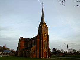 The church of Lemé | ||
| ||
 Lemé Location within Hauts-de-France region  Lemé | ||
| Coordinates: 49°50′18″N 3°45′53″E / 49.8383°N 3.7647°ECoordinates: 49°50′18″N 3°45′53″E / 49.8383°N 3.7647°E | ||
| Country | France | |
| Region | Hauts-de-France | |
| Department | Aisne | |
| Arrondissement | Vervins | |
| Canton | Marle | |
| Intercommunality | Thiérache du Centre | |
| Government | ||
| • Mayor (2008–2014) | Christian Moineuse | |
| Area1 | 11.36 km2 (4.39 sq mi) | |
| Population (2012)2 | 443 | |
| • Density | 39/km2 (100/sq mi) | |
| Time zone | UTC+1 (CET) | |
| • Summer (DST) | UTC+2 (CEST) | |
| INSEE/Postal code | 02416 /02140 | |
| Elevation |
138–183 m (453–600 ft) (avg. 164 m or 538 ft) | |
|
1 French Land Register data, which excludes lakes, ponds, glaciers > 1 km2 (0.386 sq mi or 247 acres) and river estuaries. 2 Population without double counting: residents of multiple communes (e.g., students and military personnel) only counted once. | ||

Lemé is a commune in the Aisne department in Hauts-de-France in northern France.
Population
| Historical population | ||
|---|---|---|
| Year | Pop. | ±% |
| 1962 | 590 | — |
| 1968 | 629 | +6.6% |
| 1975 | 444 | −29.4% |
| 1982 | 436 | −1.8% |
| 1990 | 478 | +9.6% |
| 1999 | 474 | −0.8% |
| 2008 | 450 | −5.1% |
| 2012 | 443 | −1.6% |
See also
References
| Wikimedia Commons has media related to Lemé. |
This article is issued from
Wikipedia.
The text is licensed under Creative Commons - Attribution - Sharealike.
Additional terms may apply for the media files.