Lavangen
| Lavangen kommune Loabága suohkan | |||
|---|---|---|---|
| Municipality | |||
 View of Inner Lavangen | |||
| |||
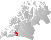 Lavangen within Troms | |||
| Coordinates: 68°39′28″N 17°35′01″E / 68.65778°N 17.58361°ECoordinates: 68°39′28″N 17°35′01″E / 68.65778°N 17.58361°E | |||
| Country | Norway | ||
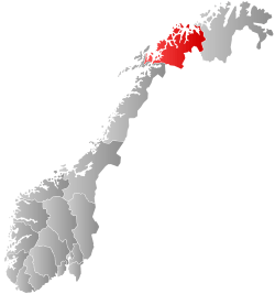
| County | Troms | ||
| District | Midt-Troms | ||
| Established | 1 Jan 1907 | ||
| Administrative centre | Tennevoll | ||
| Government | |||
| • Mayor (2015) | Bernhardt Halvorsen (Sp) | ||
| Area | |||
| • Total | 301.64 km2 (116.46 sq mi) | ||
| • Land | 296.11 km2 (114.33 sq mi) | ||
| • Water | 5.53 km2 (2.14 sq mi) 1.8% | ||
| Area rank | #278 in Norway | ||
| Population (2017) | |||
| • Total | 1,079 | ||
| • Rank | #389 in Norway | ||
| • Density | 3.6/km2 (9/sq mi) | ||
| • Change (10 years) | 6.4% | ||
| Demonym(s) | Lavangsværing[1] | ||
| Time zone | UTC+01:00 (CET) | ||
| • Summer (DST) | UTC+02:00 (CEST) | ||
| ISO 3166 code | NO-1920 | ||
| Official language form | Neutral | ||
| Website |
lavangen | ||

Lavangen (Norwegian) or Loabák (Northern Sami)[2] is a municipality in Troms county, Norway. The administrative centre of the municipality is the village of Tennevoll. Other villages in Lavangen include Fossbakken and Spansdalen (in the inland areas) and Kjeiprød, Røkenes, Låternes, Tennevoll, Hesjevika, Soløy, and Å (surrounding the fjord).
The 302-square-kilometre (117 sq mi) municipality is the 278th largest by area out of the 422 municipalities in Norway. Lavangen is the 389th most populous municipality in Norway with a population of 1,076. The municipality's population density is 3.6 inhabitants per square kilometre (9.3/sq mi) and its population has increased by 6.4% over the last decade.[3]
General information
Lavangen was established on 1 January 1907 when it was separated from Ibestad Municipality. The initial population was 1,536. During the 1960s, there were many municipal mergers across Norway due to the work of the Schei Committee. On 1 January 1964, the neighboring municipalities of Lavangen (population: 1,677) and Salangen (population: 2,611) were merged into one large municipality of Salangen. The merger was brief, however, because on 1 January 1977, the old Lavangen municipality (except for the Lavangsnes area) was made a separate municipality once again.[4]
Name
The municipality is named after the fjord (Old Norse: Laufangr). The first element is lauf which means "leaf" (here in the sense of 'birchwood') and the last element is angr which means "fjord".[5]
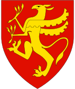
Coat of arms
The coat of arms is modern, it was granted on 18 December 1987. The arms are a canting of the name (which means leaf) since it shows three gold-colored birch leaves on a red background. The three leaves represent how the municipality was settled by Norwegians, Samis, and Kvens.[6][7]
Churches
The Church of Norway has one parish (sokn) within the municipality of Lavangen. It is part of the Indre Troms prosti (deanery) in the Diocese of Nord-Hålogaland.
| Parish (Sokn) | Church Name | Location of the Church | Year Built |
|---|---|---|---|
| Lavangen | Lavangen Church | Soløy | 1891 |
Geography
The municipality encompasses the land around the Spansdalelva river valley and most of the area around the Lavangen fjord, south of the Astafjorden. The municipality borders Narvik (in Nordland county) to the south, Gratangen to the west, Salangen to the north, and Bardu to the east.
 View of the mountain Spanstinden near Soløy
 View of the Lanvangen fjord
 Map of the municipality
 View of Skavmodalen
Climate
| Climate data for Tennevoll | |||||||||||||
|---|---|---|---|---|---|---|---|---|---|---|---|---|---|
| Month | Jan | Feb | Mar | Apr | May | Jun | Jul | Aug | Sep | Oct | Nov | Dec | Year |
| Average high °C (°F) | −3.2 (26.2) |
−2.2 (28) |
1.1 (34) |
4.5 (40.1) |
10.1 (50.2) |
15.0 (59) |
17.2 (63) |
15.6 (60.1) |
10.6 (51.1) |
4.8 (40.6) |
0.6 (33.1) |
−1.2 (29.8) |
6.1 (43) |
| Daily mean °C (°F) | −6.7 (19.9) |
−5.8 (21.6) |
−2.9 (26.8) |
1.2 (34.2) |
6.6 (43.9) |
10.9 (51.6) |
13.3 (55.9) |
12.0 (53.6) |
7.1 (44.8) |
2.4 (36.3) |
−2.4 (27.7) |
−5.0 (23) |
2.6 (36.7) |
| Average low °C (°F) | −11.5 (11.3) |
−10.2 (13.6) |
−7.4 (18.7) |
−3.4 (25.9) |
1.4 (34.5) |
6.4 (43.5) |
8.9 (48) |
7.5 (45.5) |
3.0 (37.4) |
−1.7 (28.9) |
−6.4 (20.5) |
−8.9 (16) |
−1.9 (28.6) |
| Average precipitation mm (inches) | 80 (3.15) |
81 (3.19) |
60 (2.36) |
53 (2.09) |
38 (1.5) |
59 (2.32) |
69 (2.72) |
76 (2.99) |
92 (3.62) |
113 (4.45) |
88 (3.46) |
91 (3.58) |
910 (35.83) |
| Average precipitation days (≥ 1 mm) | 11.2 | 11.8 | 10.1 | 9.3 | 8.5 | 10.9 | 12.8 | 14.8 | 14.6 | 14.7 | 12.0 | 12.0 | 142.7 |
| Source: Norwegian Meteorological Institute[8] | |||||||||||||
Government
All municipalities in Norway, including Lavangen, are responsible for primary education (through 10th grade), outpatient health services, senior citizen services, unemployment and other social services, zoning, economic development, and municipal roads. The municipality is governed by a municipal council of elected representatives, which in turn elect a mayor.[9] The municipality falls under the Ofoten District Court and the Hålogaland Court of Appeal.
Municipal council
The municipal council (Kommunestyre) of Lavangen is made up of 15 representatives that are elected to four year terms. Currently, the party breakdown is as follows:[10]
| Party Name | Name in Norwegian | Number of representatives | |
|---|---|---|---|
| Labour Party | Arbeiderpartiet | 5 | |
| Progress Party | Fremskrittspartiet | 1 | |
| Conservative Party | Høyre | 3 | |
| Centre Party | Senterpartiet | 6 | |
| Total number of members: | 15 | ||
Attractions
Spanstind rundt is a famous cross-country skiing race in Lavangen that is held on Maundy Thursdays each year.
References
- ↑ "Navn på steder og personer: Innbyggjarnamn" (in Norwegian). Språkrådet. Retrieved 2015-12-01.
- ↑ "Stadnamn og rettskriving" (in Norwegian). Kartverket. Retrieved 2018-07-13.
- ↑ Statistisk sentralbyrå (2017). "Table: 06913: Population 1 January and population changes during the calendar year (M)" (in Norwegian). Retrieved 2017-09-09.
- ↑ Jukvam, Dag (1999). "Historisk oversikt over endringer i kommune- og fylkesinndelingen" (PDF) (in Norwegian). Statistisk sentralbyrå.
- ↑ Rygh, Oluf (1911). Norske gaardnavne: Troms amt (in Norwegian) (17 ed.). Kristiania, Norge: W. C. Fabritius & sønners bogtrikkeri. p. 36.
- ↑ Store norske leksikon. "Lavangen" (in Norwegian). Retrieved 2010-04-08.
- ↑ "Civic heraldry of Norway - Norske Kommunevåpen". Heraldry of the World. Retrieved 2018-08-27.
- ↑ "eKlima Web Portal". Norwegian Meteorological Institute. Archived from the original on 2004-06-14.
- ↑ Hansen, Tore, ed. (2016-05-12). "kommunestyre". Store norske leksikon (in Norwegian). Kunnskapsforlaget. Retrieved 2018-08-26.
- ↑ "Table: 04813: Members of the local councils, by party/electoral list at the Municipal Council election (M)" (in Norwegian). Statistics Norway.
External links
- Municipal fact sheet from Statistics Norway (in Norwegian)


| |||||||||
| |||||||||
| |||||||||
| Authority control |
|---|