Lodh Falls
| Lodh Falls | |
|---|---|
 | |
| Location | Latehar district, Jharkhand. India |
| Coordinates | 23°28′50″N 84°01′10″E / 23.48056°N 84.01944°ECoordinates: 23°28′50″N 84°01′10″E / 23.48056°N 84.01944°E |
| Type | Tiered |
| Elevation | 137m |
| Longest drop | 143m (469 ft) |
| Watercourse | Burha River |
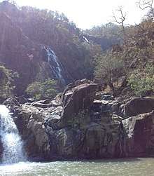
The Lodh Falls (also known as Budha waterFalls) is a waterfall in a mid forest of Latehar district of Palamu division in the Indian state of Jharkhand. It is the highest waterfall in Jharkhand and the 21st highest waterfall in India.[1]
Waterfall
It is located on the Burha River, deep in the forest of the Latehar district the Chota Nagpur Plateau.[2] The Lodh Falls is a tiered waterfall with multiple distinct drops in a relatively close succession. It is 143 metres (469 ft) high.[3] The thundering sound of the fall is audible even 10 km away.[4]
The Lodh Falls is an example of a nick point caused by rejuvenation. Knick point, also called a nick point or simply nick, represents breaks in slopes in the longitudinal profile of a river caused by rejuvenation. The break in channel gradient allows water to fall vertically giving risie to a waterfall.[5]
It is 120 km from Daltonganj, 200 km from Ranchi, and 70 km from Netarhat.
See also
References
- ↑ "Showing all Waterfalls in India". World Waterfalls Database. Archived from the original on 2009-09-01. Retrieved 2010-06-20.
- ↑ "Jharkhand". Retrieved 2006-11-13.
- ↑ "Lodh Falls". World Waterfall Database. Retrieved 2006-11-12.
- ↑ "Netarhat Introduction". Netarhat Travelite. Retrieved 2010-06-26.
- ↑ A.Z.Bukhari. "Encyclopedia of nature of geography". p. 110. Google books. Retrieved 2010-07-11.