White River (Missouri River tributary)
| White River | |
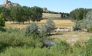 White River at the U.S. Highway 20 crossing west of Crawford in northwest Nebraska | |
| Country | United States |
|---|---|
| States | Nebraska, South Dakota |
| County | Dawes, Oglala Lakota, Pennington, Jackson, Jones, Mellette, Tripp, Lyman |
| Source | Pine Ridge |
| - location | near Harrison, Dawes County, Nebraska |
| - elevation | 4,861 ft (1,482 m) [1] |
| - coordinates | 42°41′10″N 103°50′14″W / 42.68611°N 103.83722°W [2] |
| Mouth | Missouri River |
| - location | near Chamberlain, Lyman County, South Dakota |
| - elevation | 1,601 ft (488 m) [2] |
| - coordinates | 43°42′50″N 99°28′01″W / 43.71389°N 99.46694°WCoordinates: 43°42′50″N 99°28′01″W / 43.71389°N 99.46694°W [2] |
| Length | 580 mi (933 km) [3] |
| Basin | 10,200 sq mi (26,000 km2) [4] |
| Discharge | |
| - average | 570 cu ft/s (0 m3/s) [4] |
| - max | 51,900 cu ft/s (1,500 m3/s) |
| - min | 0 cu ft/s (0 m3/s) |
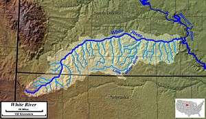 White River watershed | |
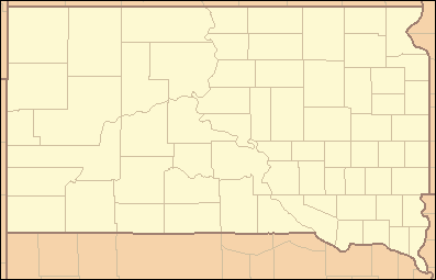 Location of the mouth of the White River in South Dakota | |

The White River is a Missouri River tributary that flows 580 miles (930 km)[3] through the U.S. states of Nebraska and South Dakota. The name stems from the water's white-gray color, a function of eroded sand, clay, and volcanic ash carried by the river[5] from its source near the Badlands.[6] Draining a basin of about 10,200 square miles (26,000 km2),[4] about 8,500 square miles (22,000 km2) of which is in South Dakota,[7] the stream flows through a region of sparsely populated hills, plateaus, and badlands.[8]
The White River rises in northwestern Nebraska, in the Pine Ridge escarpment north of Harrison, at an elevation of 4,861 feet (1,482 m) above sea level.[1] It flows southeast then northeast past Fort Robinson and north of Crawford. It crosses into southwestern South Dakota and flows north across the Pine Ridge Indian Reservation, then northeast, receiving Wounded Knee Creek and flowing between units of Badlands National Park. It flows east-northeast and southeast at the northern edge of the reservation, forming the northern boundary of the reservation and the southern boundary of Buffalo Gap National Grassland. It receives the Little White River about 15 miles (24 km) south of Murdo, and flows east to join the Missouri in Lake Francis Case about 15 miles (24 km) southwest of Chamberlain.[9]
The river sometimes has no surface flow due to the dry climate surrounding its badlands and prairie basin, though thunderstorms can cause brief intense flow. The river near Chamberlain flows year-round. The White River has generally good-quality water.[7]
See also
- White River Fauna (prehistoric)
- List of rivers of Nebraska
- List of rivers of South Dakota
References
- 1 2 Source elevation derived from Google Earth search using GNIS source coordinates.
- 1 2 3 "White River". Geographic Names Information System. United States Geological Survey. February 13, 1980. Retrieved April 24, 2011.
- 1 2 "National Hydrography Dataset". United States Geological Survey. Retrieved March 30, 2011.
- 1 2 3 Benke and Cushing, p. 471
- ↑ Benke and Cushing, p. 445
- ↑ Federal Writers' Project (1940). South Dakota place-names, v.3. University of South Dakota. p. 6.
- 1 2 Hogan, Edward Patrick; Fouberg, Erin Hogan (2001). The Geography of South Dakota (Third ed.). Sioux Falls, SD: The Center for Western Studies – Augustana College. ISBN 0-931170-79-6.
- ↑ Benke and Cushing, p. 449
- ↑ The Road Atlas (Map). Rand McNally & Company. 2008. § 62, 93. ISBN 978-0-528-93961-7.
Works cited
- Benke, Arthur C., ed., and Cushing, Colbert E., ed.; Galat, David L.; Berry, Charles R., Jr.; Peters, Edward J., and White, Robert G. (2005). "Chapter 10: Missouri River Basin" in Rivers of North America. Burlington, Massachusetts: Elsevier Academic Press. ISBN 0-12-088253-1.
| Wikimedia Commons has media related to White River (Nebraska-South Dakota). |