La Meilleraye-de-Bretagne
| La Meilleraye-de-Bretagne | ||
|---|---|---|
| Commune | ||
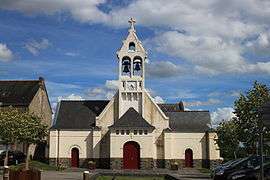 The church of Saint-Étienne, in La Meilleraye-de-Bretagne | ||
| ||
 La Meilleraye-de-Bretagne Location within Pays de la Loire region  La Meilleraye-de-Bretagne | ||
| Coordinates: 47°33′37″N 1°24′01″W / 47.5603°N 1.4003°WCoordinates: 47°33′37″N 1°24′01″W / 47.5603°N 1.4003°W | ||
| Country | France | |
| Region | Pays de la Loire | |
| Department | Loire-Atlantique | |
| Arrondissement | Châteaubriant-Ancenis | |
| Canton | Châteaubriant | |
| Intercommunality | Castelbriantais | |
| Government | ||
| • Mayor (2008–2014) | Michel Moreau | |
| Area1 | 27.63 km2 (10.67 sq mi) | |
| Population (2006)2 | 1,197 | |
| • Density | 43/km2 (110/sq mi) | |
| Demonym(s) | Meilleréens, Meilleréennes | |
| Time zone | UTC+1 (CET) | |
| • Summer (DST) | UTC+2 (CEST) | |
| INSEE/Postal code | 44095 /44520 | |
| Elevation | 29–91 m (95–299 ft) | |
| Website | la-meilleraye-de-bretagne.monclocher.fr | |
|
1 French Land Register data, which excludes lakes, ponds, glaciers > 1 km2 (0.386 sq mi or 247 acres) and river estuaries. 2 Population without double counting: residents of multiple communes (e.g., students and military personnel) only counted once. | ||
.svg.png)
La Meilleraye-de-Bretagne is a commune in the Loire-Atlantique department in western France.
See also
| Wikimedia Commons has media related to La Meilleraye-de-Bretagne. |
This article is issued from
Wikipedia.
The text is licensed under Creative Commons - Attribution - Sharealike.
Additional terms may apply for the media files.