Château-Thébaud
| Château-Thébaud | ||
|---|---|---|
| Commune | ||
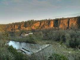 Les bords de Maine à Pont-Caffino. | ||
| ||
 Château-Thébaud Location within Pays de la Loire region  Château-Thébaud | ||
| Coordinates: 47°07′33″N 1°25′07″W / 47.1258°N 1.4186°WCoordinates: 47°07′33″N 1°25′07″W / 47.1258°N 1.4186°W | ||
| Country | France | |
| Region | Pays de la Loire | |
| Department | Loire-Atlantique | |
| Arrondissement | Nantes | |
| Canton | Vertou | |
| Intercommunality | Sèvre, Maine et Goulaine | |
| Government | ||
| • Mayor (2008–2014) | Jean Paul Loyer | |
| Area1 | 17.64 km2 (6.81 sq mi) | |
| Population (2006)2 | 2,731 | |
| • Density | 150/km2 (400/sq mi) | |
| Time zone | UTC+1 (CET) | |
| • Summer (DST) | UTC+2 (CEST) | |
| INSEE/Postal code | 44037 /44690 | |
| Elevation | 2–60 m (6.6–196.9 ft) | |
| Website | http://www.chateau-thebaud.fr/ | |
|
1 French Land Register data, which excludes lakes, ponds, glaciers > 1 km2 (0.386 sq mi or 247 acres) and river estuaries. 2 Population without double counting: residents of multiple communes (e.g., students and military personnel) only counted once. | ||
.svg.png)
Château-Thébaud is a commune in the Loire-Atlantique department in western France.
See also
| Wikimedia Commons has media related to Château-Thébaud. |
| Authority control |
|---|
This article is issued from
Wikipedia.
The text is licensed under Creative Commons - Attribution - Sharealike.
Additional terms may apply for the media files.