Guenrouet
| Guenrouet | ||
|---|---|---|
| Commune | ||
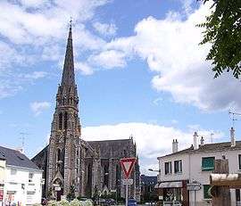 The church in Guenrouet | ||
| ||
 Guenrouet Location within Pays de la Loire region  Guenrouet | ||
| Coordinates: 47°31′12″N 1°57′13″W / 47.52°N 1.9536°WCoordinates: 47°31′12″N 1°57′13″W / 47.52°N 1.9536°W | ||
| Country | France | |
| Region | Pays de la Loire | |
| Department | Loire-Atlantique | |
| Arrondissement | Saint-Nazaire | |
| Canton | Pontchâteau | |
| Intercommunality | Pays de Pont-Château - Saint-Gildas-des-Bois | |
| Government | ||
| • Mayor (2008–2014) | Sylvain Robert | |
| Area1 | 69.9 km2 (27.0 sq mi) | |
| Population (2006)2 | 2,780 | |
| • Density | 40/km2 (100/sq mi) | |
| Demonym(s) | Guérinoises, Guérinois | |
| Time zone | UTC+1 (CET) | |
| • Summer (DST) | UTC+2 (CEST) | |
| INSEE/Postal code | 44068 /44530 | |
| Elevation | 0–73 m (0–240 ft) | |
| Website | www.cc-paysdepontchateau.fr | |
|
1 French Land Register data, which excludes lakes, ponds, glaciers > 1 km2 (0.386 sq mi or 247 acres) and river estuaries. 2 Population without double counting: residents of multiple communes (e.g., students and military personnel) only counted once. | ||
.svg.png)
Guenrouet (also spelled Guenrouët; Breton: Gwenred) is a commune in the Loire-Atlantique department in western France.
See also
- Communes of the Loire-Atlantique department
- The works of Jean Fréour. Sculptor with works in Guenrouet's Église de Notre Dame de Grâce.
| Wikimedia Commons has media related to Guenrouet. |
This article is issued from
Wikipedia.
The text is licensed under Creative Commons - Attribution - Sharealike.
Additional terms may apply for the media files.