Kvalsund (village)
| Kvalsund Ráhkkerávju | |
|---|---|
| Village | |
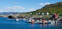 View of the village | |
 Kvalsund Location in Finnmark  Kvalsund Kvalsund (Norway) | |
| Coordinates: 70°30′09″N 23°58′47″E / 70.50250°N 23.97972°ECoordinates: 70°30′09″N 23°58′47″E / 70.50250°N 23.97972°E | |
| Country | Norway |
| Region | Northern Norway |
| County | Finnmark |
| District | Vest-Finnmark |
| Municipality | Kvalsund |
| Area[1] | |
| • Total | 0.29 km2 (0.11 sq mi) |
| Elevation[2] | 2 m (7 ft) |
| Population (2017)[1] | |
| • Total | 288 |
| • Density | 993/km2 (2,570/sq mi) |
| Time zone | UTC+01:00 (CET) |
| • Summer (DST) | UTC+02:00 (CEST) |
| Post Code | 9620 Kvalsund |
Kvalsund (Northern Sami: Ráhkkerávju) is the administrative centre of Kvalsund Municipality in Finnmark county, Norway. The village is located on the mainland, along the Kvalsundet strait, at the mouth of the river Kvalsundelva. The village sits just east of the Kvalsund Bridge which connects the mainland to the island of Kvaløya, just to the north. Kvalsund Church, the main church for the municipality, is located in this village.
The 0.29-square-kilometre (72-acre) village has a population (2017) of 288 which gives the village a population density of 993 inhabitants per square kilometre (2,570/sq mi).[1]
References
- 1 2 3 Statistisk sentralbyrå (1 January 2017). "Urban settlements. Population and area, by municipality".
- ↑ "Kvalsund" (in Norwegian). yr.no. Retrieved 2013-01-26.
This article is issued from
Wikipedia.
The text is licensed under Creative Commons - Attribution - Sharealike.
Additional terms may apply for the media files.