Kurihara, Miyagi
| Kurihara 栗原市 | |||
|---|---|---|---|
| City | |||
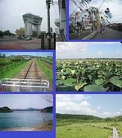 Kurihara-Kogen Station, Tanabata, Kuriden Rail Park, Lotus flowers, Hanayama Dam, Kurikoma QNP | |||
| |||
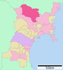 Location of Kurihara in Miyagi Prefecture | |||
 Kurihara | |||
| Coordinates: 38°43′48.4″N 141°1′17.3″E / 38.730111°N 141.021472°ECoordinates: 38°43′48.4″N 141°1′17.3″E / 38.730111°N 141.021472°E | |||
| Country | Japan | ||
| Region | Tōhoku | ||
| Prefecture | Miyagi | ||
| Government | |||
| • -Mayor | Isamu Satō | ||
| Area | |||
| • Total | 804.97 km2 (310.80 sq mi) | ||
| Population (May 31, 2017) | |||
| • Total | 69,925 | ||
| • Density | 86.8/km2 (225/sq mi) | ||
| Time zone | UTC+9 (Japan Standard Time) | ||
| - Tree | Kousa Dogwood | ||
| - Flower | Nikkōkisuge (Hemerocallis dumortieri var. esculenta) | ||
| Phone number | 0228-22-1122 | ||
| Address | 1-7-1 Tsukidate Yakushi, Kurihara-shi, Miyagi-ken 987-2293 | ||
| Website | http://www.kuriharacity.jp/ | ||


Kurihara (栗原市 Kurihara-shi) is a city located in Miyagi Prefecture, Japan. As of 31 May 2017, the city had an estimated population of 69,925, and a population density of 86.8 persons per km² in 24,894 households.[1] The total area of the city is 804.97 square kilometres (310.80 sq mi). Parts of the city are within the borders of the Kurikoma Quasi-National Park.
Geography
Kurihara covers a part of the northwestern corner of Miyagi Prefecture. It is mostly rice farmland, and small mountain ridges, the largest of which cluster around Mount Kurikoma, the tallest mountain in Kurihara, which is located at the furthest northwestern point of Miyagi Prefecture. In summer, the lotus on Lake Izunuma bloom. In fall, Mount Kurikoma is covered in fall colors and in winter migrating swans and geese come in flocks to spend the season on Kurihara's lakes.
Climate
The climate of Kurihara is classified as humid continental (Cfa) per the Köppen climate classification system. As with most of Japan, the summers in Kurihara are hot and humid with temperatures usually around 24.5 °C (76.1 °F). Summer is also typhoon season, however, since Kurihara is so far north and inland the area is rarely affected. Fall and spring are mild, with temperatures in the low to mid 20s (Celsius). In fall, the days usually begin foggy and cold but clear up by midday. Spring comes late to the region and is mostly sunny punctuated with random light showers. The temperature fluctuates around freezing in winter, falling to an average low of −1.3 °C (29.7 °F), and snow levels vary with altitude..[2]
| Climate data for Kurihara, Miyagi (former Kurikoma town) (1981-2010) | |||||||||||||
|---|---|---|---|---|---|---|---|---|---|---|---|---|---|
| Month | Jan | Feb | Mar | Apr | May | Jun | Jul | Aug | Sep | Oct | Nov | Dec | Year |
| Average high °C (°F) | 0.0 (32) |
0.5 (32.9) |
4.0 (39.2) |
11.3 (52.3) |
16.8 (62.2) |
19.8 (67.6) |
23.0 (73.4) |
25.0 (77) |
20.7 (69.3) |
15.3 (59.5) |
9.0 (48.2) |
3.1 (37.6) |
12.4 (54.3) |
| Daily mean °C (°F) | −3.0 (26.6) |
−2.7 (27.1) |
0.2 (32.4) |
6.4 (43.5) |
11.7 (53.1) |
15.5 (59.9) |
19.2 (66.6) |
20.8 (69.4) |
16.7 (62.1) |
10.8 (51.4) |
5.0 (41) |
0.0 (32) |
8.4 (47.1) |
| Average low °C (°F) | −6.5 (20.3) |
−6.3 (20.7) |
−3.7 (25.3) |
1.5 (34.7) |
6.5 (43.7) |
11.4 (52.5) |
15.7 (60.3) |
17.2 (63) |
13.0 (55.4) |
6.5 (43.7) |
0.8 (33.4) |
−3.4 (25.9) |
4.4 (39.9) |
| Source: Japan Meteorological Agency[3] | |||||||||||||
| Climate data for Kurihara, Miyagi (former Tsukidate Town) (1981-2010) | |||||||||||||
|---|---|---|---|---|---|---|---|---|---|---|---|---|---|
| Month | Jan | Feb | Mar | Apr | May | Jun | Jul | Aug | Sep | Oct | Nov | Dec | Year |
| Average high °C (°F) | 3.9 (39) |
4.8 (40.6) |
8.7 (47.7) |
15.4 (59.7) |
20.3 (68.5) |
23.4 (74.1) |
26.5 (79.7) |
28.5 (83.3) |
24.3 (75.7) |
18.9 (66) |
12.6 (54.7) |
6.9 (44.4) |
16.2 (61.2) |
| Daily mean °C (°F) | −0.6 (30.9) |
0.1 (32.2) |
3.3 (37.9) |
9.1 (48.4) |
14.4 (57.9) |
18.3 (64.9) |
21.8 (71.2) |
23.5 (74.3) |
19.3 (66.7) |
13.1 (55.6) |
6.9 (44.4) |
2.2 (36) |
11.1 (52) |
| Average low °C (°F) | −5.0 (23) |
−4.6 (23.7) |
−1.8 (28.8) |
3.0 (37.4) |
9.2 (48.6) |
14.2 (57.6) |
18.3 (64.9) |
19.8 (67.6) |
15.1 (59.2) |
7.9 (46.2) |
1.8 (35.2) |
−2.2 (28) |
6.3 (43.3) |
| Source: Japan Meteorological Agency[4] | |||||||||||||
Neighboring municipalities
- Miyagi Prefecture
- Akita Prefecture
- Iwate Prefecture
Demographics
Per Japanese census data,[5] the population of Kurihara has declined over the past 40 years.
| Census Year | Population |
|---|---|
| 1970 | 104,888 |
| 1980 | 95,801 |
| 1990 | 91,852 |
| 2000 | 84,947 |
| 2010 | 74,932 |
History
The area of present-day Kurihara was part of ancient Mutsu Province, and has been settled since at least the Jōmon period by the Emishi people. During the later portion of the Heian period, the area was ruled by the Northern Fujiwara. During the Sengoku period, the area was contested by various samurai clans before the area came under the control of the Date clan of Sendai Domain during the Edo period, under the Tokugawa shogunate.
With the establishment of the modern municipalities system on April 1, 1889, the area was organized into Kurihara District, Miyagi Prefecture.
During the Meiji period, many mines were dug in the mountains of Kurihara, and the Hosokura mine was at one point Japan’s largest producer of lead and zinc. The mine closed in 1987.
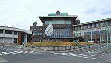
The modern city of Kurihara was established on April 1, 2005, from the merger of the towns of Ichihasama, Kannari, Kurikoma, Semine, Shiwahime, Takashimizu, Tsukidate, Uguisuzawa and Wakayanagi, and the village of Hanayama (all from Kurihara District, which was dissolved as a result of the merge). The new city hall is located in former Tsukidate. Although technically referred to as a "city", Kurihara in fact functions more like a county composed of ten separate towns. The UK equivalent would be an English unitary county council, such as Herefordshire.
Government
Kurihara has a mayor-council form of government with a directly elected mayor and a unicameral city legislature of 26 members.
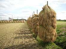
Economy
The economy of Kurihara is largely based on agriculture.
Education
Kurihara has 13 public elementary schools and nine public junior high schools operated by the city government and five public high schools operated by the Miyagi Prefectural Board of Education. Miyagi Prefectural also operates one special education school.
Transportation
Railway
- East Japan Railway Company (JR East) – Tōhoku Shinkansen
- East Japan Railway Company (JR East) – Tōhoku Main Line
Highway
Local attractions
- Kurikoma Quasi-National Park is centered on Mt. Kurikoma, a dormant volcano straddling the tri-prefectural border of Miyagi, Akita and Iwate. It is 1627 meters high, conical, and has a 365 degree panoramic view. There is an abundance of diverse alpine flora in the wetlands near its peak and expansive virgin beech forests that are home to many precious birds, insects, and other fauna. There are extensive hiking trails with hot springs located at the base and top of the mountain.
- Sekai Yachi Wetlands Flower Park is a 14.34-hectare wetlands area is situated in the southern foothills of Mt. Kurikoma, between 669 and 707 meters above sea level. Late June is the best time to see the Middendorff's daylilies. The flowering seasons are spring and summer.
- Miyagi Prefectural Sanctuary Center of Izunuma-Uchinuma is a protected area created in order to protect the abundant plant and animal life in the area. Lake Izunuma, the largest lake in Miyagi, is home to 223 species of waterfowl, or 42% of Japan's 535 total species of water birds. Migrating birds including swans, geese, and ducks, winter here. From late July to late August is when the lotus flowers bloom and the Izunuma-Uchinuma Lotus Festival is held.
Culture
Kurihara is known for its rice production. There are also a number of waterfalls, parks filled with cherry blossoms in spring, and flower gardens. These include: Abazu Gorge, Shiraito Falls, Gorindoyama Park, Hasama River Park, and Sanno Historic Park Iris Garden.
It is also a renowned place for viewing the autumn leaves, especially around Mt. Kurikoma. Kurihara also has an abundance of hot spring resorts. These include: Yu-no-Kura Hot Spring, Yubama Hot Spring, Hanayama Hot Spring, and Nuruyu Hot Spring.
Festivals
- Late March Tohoku Draft Horse Pull Kurikoma Tournament (Kurikoma)
- 1st Sun of April Obasama Festival and Longevity Rites (Kannari)
- Mid-April Izumiya Oyashiki Festival (Semine)
- April 29 Masaoka Festival (Ichihasama)
- Mid-April Cherry Blossom Festivals (all areas)
- May 5 Hanayama Rifle Festival (Hanayama)
- Mid-June Iris Festival (Ichihasama)
- Mid-June Ichihasama Lily Garden Opening (Ichihasama)
- 1st Sun of July Iris Festival and Kagura Sacred Dance (Ichihasama)
- 3rd Sun of July Michinoku Kagura Sacred Dance Festival (Tsukidate)
- Late July Kurikoma Float Parade Festival (Kurikoma)
- August Izunuma-Uchinuma Lotus Festival (Wakayanagi, Tsukidate)
- August 5–6 Tsukidate Tanabata Festival (Tsukidate)
- August 14 Waterwheel (Suisha) Festival (Shiwahime)
- August 15–16 Wakayanagi Summer Festival (Wakayanagi)
- Early October Autumn Lake Festival (Hanayama)
- Oct-Nov Tagaiichi Markets and Festivals
- November 3 Tsukidate Yakushi Festival
- Early Nov Industries Festival
- Dec-Feb Festivals to Beckon and Welcome Spring (all areas)
- Mid-Jan Donto Festivals (all areas)
Noted people from Kurihara
- Yoshiaki Hoshi – musician
- Kōbōyama Daizō – sumo wrestler
- Jun Izumida – professional wrestler
References
- ↑ Kurihara city official home page(in Japanese)
- ↑ Kurihara climate data
- ↑ "駒の湯(栗原) 1981-2010年". JMA. Retrieved 2011-10-18.
- ↑ "築館(栗原) 19801-2010年". JMC. Retrieved 2011-10-18.
- ↑ Kurihara population statistics
External links
| Wikimedia Commons has media related to Kurihara, Miyagi. |
- Official Website (in Japanese)
| Wards of Sendai | |
|---|---|
| Cities | |
| Districts | |
| Authority control |
|---|