Kuna, Idaho
| Kuna, Idaho | ||
|---|---|---|
| City | ||
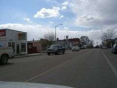 Main Street in Kuna in 2008 | ||
| ||
| Motto(s): "Gateway city to the birds of prey" | ||
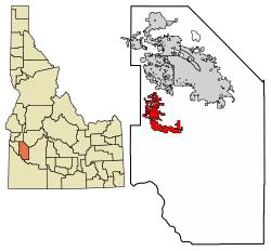 Location of Kuna in Ada County, Idaho | ||
 Kuna, Idaho Location in the United States | ||
| Coordinates: 43°29′35″N 116°25′8″W / 43.49306°N 116.41889°WCoordinates: 43°29′35″N 116°25′8″W / 43.49306°N 116.41889°W | ||
| Country | United States | |
| State | Idaho | |
| County | Ada | |
| Government | ||
| • Mayor | Joe Stear | |
| Area[1] | ||
| • Total | 18.42 sq mi (47.70 km2) | |
| • Land | 18.32 sq mi (47.45 km2) | |
| • Water | 0.10 sq mi (0.25 km2) | |
| Elevation | 2,694 ft (821 m) | |
| Population (2010)[2] | ||
| • Total | 15,210 | |
| • Estimate (2016)[3] | 17,902 | |
| • Density | 977.08/sq mi (377.26/km2) | |
| Time zone | UTC−7 (Mountain) | |
| • Summer (DST) | UTC−6 (Mountain) | |
| ZIP code | 83634 | |
| Area code(s) | 208 | |
| FIPS code | 16-44290 | |
| GNIS feature ID | 0396755 | |
| Website |
www | |

Kuna is a city in Ada County, Idaho, United States. It is part of the Boise City–Nampa, Idaho Metropolitan Statistical Area. The population was 15,210 at the 2010 census.[4]
Kuna is one of the fastest-growing areas in Idaho, having nearly tripled in population between 2000 and 2010.
Kuna is commonly misspelled and mispronounced as "Koona", but is correctly pronounced /kyo͞ona/.
Geography
Kuna is located at 43°29′35″N 116°25′8″W / 43.49306°N 116.41889°W (43.493092, -116.418936)[5] at an elevation of 2,694 feet (821 m) above sea level. Kuna's business center is approximately 18 miles (29 km) southwest of downtown Boise, the state capital.
According to the United States Census Bureau, the city has a total area of 18.18 square miles (47.09 km2), of which, 18.08 square miles (46.83 km2) is land and 0.10 square miles (0.26 km2) is water.[6]
South of Kuna is located the Kuna Caves, an underground lava flow cave.
A small seasonal creek, Indian Creek, runs through the city. It is now used as an irrigation canal, filled by the New York Canal from the Boise River Diversion Dam. One of the few small floatable waterways in the region, Indian Creek is a favorite swimming spot for local residents.
History
Kuna originated as a railroad stop with coach transport to Boise. It is popularly believed, as cited by the Kuna Chamber of Commerce, that the translation of the name "Kuna" means "the end of the trail", but Charles S. Walgamott cites the origin of the name as a Shoshone Indian word meaning "green leaf, good to smoke."[7]
The Western Heritage Historic Byway, designated as a national as well as a state scenic byway, travels around a number of historic sites in the area.
Demographics
| Historical population | |||
|---|---|---|---|
| Census | Pop. | %± | |
| 1920 | 366 | — | |
| 1930 | 398 | 8.7% | |
| 1940 | 443 | 11.3% | |
| 1950 | 534 | 20.5% | |
| 1960 | 516 | −3.4% | |
| 1970 | 593 | 14.9% | |
| 1980 | 1,767 | 198.0% | |
| 1990 | 1,955 | 10.6% | |
| 2000 | 5,382 | 175.3% | |
| 2010 | 15,210 | 182.6% | |
| Est. 2016 | 17,902 | [3] | 17.7% |
| U.S. Decennial Census[8] | |||
As of 2000 the median income for a household in the city was $62,852. Males had a median income of $32,236 versus $22,473 for females. The per capita income for the city was $13,891. About 10.1% of families and 14.2% of the population were below the poverty line, including 19.3% of those under age 18 and 33.0% of those age 65 or over.
2010 census
As of the census[2] of 2010, there were 15,210 people, 4,782 households, and 3,838 families residing in the city. The population density was 841.3 inhabitants per square mile (324.8/km2). There were 5,108 housing units at an average density of 282.5 per square mile (109.1/km2). The racial makeup of the city was 91.2% White, 0.6% African American, 0.8% Native American, 0.7% Asian, 0.1% Pacific Islander, 3.6% from other races, and 2.9% from two or more races. Hispanic or Latino people of any race were 8.6% of the population.
There were 4,782 households of which 56.1% had children under the age of 18 living with them, 63.3% were married couples living together, 11.9% had a female householder with no husband present, 5.1% had a male householder with no wife present, and 19.7% were non-families. 14.8% of all households were made up of individuals and 3.9% had someone living alone who was 65 years of age or older. The average household size was 3.18 and the average family size was 3.53.
The median age in the city was 28.1 years. 37.7% of residents were under the age of 18; 7.4% were between the ages of 18 and 24; 35.1% were from 25 to 44; 15.3% were from 45 to 64; and 4.4% were 65 years of age or older. The gender makeup of the city was 49.9% male and 50.1% female.
Government and infrastructure
The United States Postal Service operates the Kuna Post Office.[9]
The Idaho Department of Correction operates the South Boise Prison Complex,[10] including the Idaho State Correctional Institution in unincorporated Ada County, near Kuna.[11]
Culture
During the first weekend in August, there is an annual celebration called Kuna Days. Regular festivities include vendors in the park, live music at the bandshell, a free kids carnival, a rubber duck race in Indian Creek, a BBQ fundraiser at the fire station, a parade, a street dance, and a fireworks show.[12]
The Snake River Birds of Prey Festival is held every year in mid-May. Taking advantage of the nearby Morley Nelson Snake River Birds of Prey National Conservation Area, which holds North America's densest population of nesting raptors, it offers lectures and tours about raptors, as well as about local history.[13]
Recreation
Veteran's Memorial Park
In the city center is Colonel Bernard Fisher Veteran's Memorial Park, named after one of the city's most famous residents.
Notable people
- Bernard Fisher, awarded the Medal of Honor
- Robin Fontes, Army Major General and highest ranking woman in Afghanistan
Notes
- ↑ "2016 U.S. Gazetteer Files". United States Census Bureau. Archived from the original on March 19, 2017. Retrieved July 26, 2017.
- 1 2 "American FactFinder". United States Census Bureau. Archived from the original on February 17, 2012. Retrieved December 18, 2012.
- 1 2 "Population and Housing Unit Estimates". Archived from the original on May 29, 2017. Retrieved June 9, 2017.
- ↑ "Quickfacts: Kuna, Idaho". United States Census Bureau, Population Division. 2010. Archived from the original on January 20, 2012. Retrieved December 9, 2011.
- ↑ "US Gazetteer files: 2010, 2000, and 1990". United States Census Bureau. February 12, 2011. Archived from the original on March 12, 2012. Retrieved April 23, 2011.
- ↑ "US Gazetteer files 2010". United States Census Bureau. Archived from the original on July 14, 2012. Retrieved December 18, 2012.
- ↑ Walgamott, Charles Shirley (2016). Six Decades Back. Pickle Partners Publishing. ISBN 9781787201958.
- ↑ "Census of Population and Housing". Census.gov. Archived from the original on May 12, 2015. Retrieved June 4, 2015.
- ↑ "Post Office™ Location - KUNA Archived January 29, 2011, at the Wayback Machine.." United States Postal Service. Retrieved on June 4, 2011.
- ↑ "Information Technology Projects Archived October 7, 2011, at the Wayback Machine.." Idaho Department of Correction. March 2011. Retrieved on June 3, 2011.
- ↑ "Locations Archived May 19, 2011, at the Wayback Machine.." Idaho Department of Correction. Retrieved on June 4, 2011. Kuna area addresses: "South Idaho Correctional Institution Community Work Center (CWC) 14195 S. Pleasant Valley Road Kuna ID 83634" "Correctional Alternative Placement Program (CAPP) 15505 S. Pleasant Valley Rd. Kuna ID 83634" "Idaho Correctional Center (ICC) 14601 S. Pleasant Valley Rd Kuna ID 83634" "Idaho Maximum Security Institution (IMSI) 13400 S. Pleasant Valley Rd Kuna ID 83634" "Idaho State Correctional Institution (ISCI) 13500 S. Pleasant Valley Rd Kuna ID 83634" "South Boise Women's Correctional Center (SBWCC) 13200 S. Pleasant Valley Rd. Kuna ID 83634" "South Idaho Correctional Institution (SICI) 13900 S. Pleasant Valley Rd Kuna ID 83634"
- ↑ "Guide to Kuna Days – Celebrating Kuna's 150th Birthday". Kuna Melba News. Archived from the original on August 8, 2014.
- ↑ "Archived copy". Archived from the original on February 2, 2011. Retrieved April 4, 2010.
External links
- Official website
- Kuna Chamber of Commerce
- kuna360.com
- Kuna Melba News, newspaper of city record
- Kuna Farmers Market
- Kuna Historical Society
- Kuna Library District
- Western Heritage Historic Byway
Municipalities and communities of Ada County, Idaho, United States | ||
|---|---|---|
| Cities | ||
| CDP | ||