Kayin State
| Kayin State ကညီကီၢ်ဆဲၣ် | ||
|---|---|---|
| State | ||
| ကရင်ပြည်နယ် | ||
| Other transcription(s) | ||
| • Karen | k'nyaw kawseh | |
| • Burmese | ka.yang pranynai | |
| ||
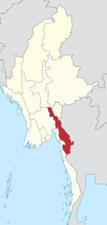 Location of Kayin State in Myanmar | ||
| Coordinates: 17°0′N 97°45′E / 17.000°N 97.750°ECoordinates: 17°0′N 97°45′E / 17.000°N 97.750°E | ||
| Country |
| |
| Region | Southeast | |
| Capital | Hpa-An | |
| Government | ||
| • Chief Minister | Nang Khin Htwe Myint (NLD) | |
| • Cabinet | Kayin State Government | |
| • Legislature | Kayin State Hluttaw | |
| • High Court | Karen State High Court | |
| Area | ||
| • Total | 30,382.8 km2 (11,730.9 sq mi) | |
| Area rank | 11th | |
| Population (2014 Census)[1] | ||
| • Total | 1,574,079 | |
| • Rank | 11th | |
| • Density | 52/km2 (130/sq mi) | |
| Demonym(s) | Karen, Kayinese | |
| Demographics | ||
| • Ethnicities | Karen (majority), Padaung, Bamar, Shan, Pa-O, Mon, Rakhine, Burmese-Thai | |
| • Religions |
Buddhism 84.50% Christianity 9.50% Islam 4.60% Hinduism 0.60% animism 0.10% Others 0.70% | |
| Time zone | UTC+06:30 (MMT) | |
| Official language | Karen | |
| Website |
www | |

Kayin State (Phlone: ဖၠုံခါန်ႋကၞင့်; S'gaw Karen: ကညီကီၢ်ဆဲၣ်, pronounced [kɲɔkɔshæ], Burmese: ကရင်ပြည်နယ်, pronounced [kəjɪ̀ɴ pjìnɛ̀]; formerly Karen State) is a state of Myanmar. The capital city is Hpa-An, also spelled Pa-An.
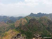
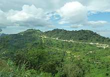
The relief of Kayin State is mountainous with the Dawna Range running along the state in a NNW - SSE direction and the southern end of the Karen Hills in the northwest.[2] It is bordered by Mae Hong Son, Tak, and Kanchanaburi provinces of Thailand to the east; Mon State and Bago Region to the west and south; Mandalay Region, Shan State and Kayah State to the north.
History
| Historical population | ||
|---|---|---|
| Year | Pop. | ±% |
| 1973 | 858,429 | — |
| 1983 | 1,055,359 | +22.9% |
| 2014 | 1,574,079 | +49.2% |
| Source: 2014 Myanmar Census[1] | ||
The region that forms today's Kayin State was part of successive Burmese kingdoms since the formation of the Pagan Empire in mid-11th century. During the 13th to 16th centuries, much of the region belonged to the Hanthawaddy Kingdom, while the northern part of the region belonged to Taungoo,a vassal state of Ava Kingdom. The region became part of Taungoo Dynasty and Konbaung Dynasty from 16th to 19th centuries. The British seized the southern third of today's Kayin State (below the Salween River) after the First Anglo-Burmese War (1824-1826), and the rest after the Second Anglo-Burmese War of 1852.
Towards the end of the British colonial era (1945-1948), the Karen leadership insisted on a separate state covering today's Kayin State and much of Mon State and Taninthayi Region, within the British Empire. They refused to sign the Panglong Agreement of February 1947, which was the basis for the 1947 Constitution of Burma, and boycotted the pre-independence elections of April 1947.[3] Nonetheless, the constitution granted the Karen a state, though with an area less than what the Karen leadership had asked for from the British. The constitution also guaranteed states with the right to secede from the Union after a period of 10 years. (The Panglong Agreement gave only the Shan and the Kachin a state each; the Chin who actually signed the agreement did not receive a state.) The Karen National Union, which dominated the Karen leadership, was not satisfied, and wanted outright independence. In 1949, the KNU raised a rebellion that continues up to today.[4] The KNU celebrates January 31 as 'revolution day', marking the day they went underground at the battle of Insein.
Much of the state has been a battlefield since then. The civilians have taken the brunt of the war. The KNU today forms the world's longest-running resistance. The military government changed the English name of the state to Kayin State from Karen State in 1989.
Geography
Located between latitudes 15° 45' north and 19° 25' north and longitudes 96° 10' east and 98° 28' east. It has a hot and humid climate because of the mountain ranges that lie in its backdrop and its location, which is near the sea, in the tropics. The temperature of the hottest month in eastern mountain regions never falls below 22.2 °C (71.9 °F). Lowlands in the west and south of the state are located in the tropical monsoon climate. The lowest annual rainfall in the region is 3,000 millimetres (120 in) and the highest is 4,800 millimetres (190 in). The regions get most of the rain in summer. Some of the rivers and creeks in Kayin State are flowing from south to north due to the location of mountains. The main rivers in the state are Thanlwin (Salween River), Thaungyin (Moei River), Gyaing and Attaran.
Administrative divisions
Kayin State consists of one city and nine towns. It has four districts, seven townships and 4092 villages.
Districts
Townships
Cities and towns
Villages and hamlets
- Tagondaing
- Kale
- Htimahto
- Kyongawon
- Winpauk
- Taungdi
- Myohaung
- Anankwin
- Phabya
- Karesaw
- Kyaukbilu
- Pu Lein
- Kyeikywa
- Khonkhan
- Apalon
- Kanni I
- Htipalamaw
- Hlagazaing
- Kawankathaung
- Winhtaung
- Lutshan
- Paya-ngokto
- Katokkra
- Kaingdaw
- Peinnegon (15°58'0"N 98°21'0"E)
- Peinnegon (16°15'0"N 98°21'0"E)
- Peinnegon (16°22'0"N 98°19'0"E)
- Kanni II
- Thabyegon
- Myaingkon
- Naungkwe
- Naungpalein
- Thanbaya
- Thabyu
- Retphaw
- Phadaw
- Winkana
- Nyeinchanmyine
- Htilonhpaung
- Doh-Li
- Duk Daw Nain
- Tamoowoug
- Akalaw
- Ywathit
- Kronwa
- Kyungyaung
- Tanyin
- Shitpyit (15°35'0"N 98°6'0"E)
- Shitpyit (15°36'0"N 98°6'0"E)
- Lonsi
- Missakit
- Na-awn
- Pyinmahtein
- Yapru
- Putaw
- Kalonhte
- Kyauk Bi Lu
- Phathalē
- Taungbauk
- Than Pu Yar (Thanbaya)
Due to the mountainous terrain in Kayin State, most villages are small and contain less than 40 households so a large amount of Kayin's population is dotted across the countryside over hundreds, if not thousands of villages. [5]
Demographics
Population
Since the 1973 Census, the population of Kayin State has increased from 858,429 to 1,055,359 in the 1983 census and 1,574,079 in the census of 2014. This means the population of Kayin State has increased by about 49 percent between the 1983 and the 2014 census. The population of Kayin State ranks eleventh in size when compared with other States and Regions in the country, only higher than Tanintharyi Region, Nay Pyi Taw Union Territory and Chin State. In terms of the proportion of the total population, the population of Kayin State has marginally increased from 3.0 percent in 1983 to 3.1 percent in 2014.[6]
Religion
The primary religions practised in Kayin State are Buddhism, Christianity and Islam.
Religion in Kayin (2015)[7]
Economy
Tourism
Tourism is one of the main economy of Kayin State. After the signing of the preliminary ceasefire between the KNU and the Myanmar government in 2012, the number of visitors to Kayin State increased largely.[8] Kayin State experienced over 40,000 tourists in 2013, followed by 50,000 in 2014. In 2016, the number of visitors reached a record 150,000.[8]
Border Trade
Myawaddy border trading post of Kayin State is the second biggest among Myanmar’s 15 border trading posts.[9] It is the main border crossing trade route between Thailand and Myanmar. According to Thailand’s Chamber of Commerce, the monthly trade between the two countries in 2015 through the Mae Sot to Myawaddy crossing was worth over 3 billion baht (about 90 million US dollar).[10]
Agriculture
Kayin State is a farming state. Currently, there are over 460,000 acres of paddy fields and 260,000 acres of rubber tree plantations in Kayin State.[11] There is over 9000 acres of coffee land in Thandaung area. The Kayin State government is trying to implement new farming technology to improve its agriculture sector.[11]
Industry
In 2016, the government announced a strategy to attract domestic and foreign investors to the Hpa-An industrial zone.[12] However, shortage of electricity supply hinders the development of Hpa-An industrial zone. The Kayin State government in conjunction with a Japanese company has been trying to carry out a feasibility survey for an 1800-megawatt coal-fired power plant to fulfill the need of electricity supply. On the other hand, community members and local environmental groups have raised concerns about the potential impacts from coal plant emissions.[13]
Transport
Kayin State is served by Hpapun Airport and Hpa-An Airport but none of those currently use for public transportation.
In 2015, the Asian Development Bank (ADB) approved a $100 million loan to improve a 66.4 kilometer section of road connecting the towns of Eindu and Kawkareik in Kayin state, the missing link of the Greater Mekong Subregion (GMS) East-West Corridor.[14]
Education
Major universities in Kayin state include Hpa-An University, Computer University, Hpa-An and Technological University, Hpa-An.
Educational opportunities in Myanmar are limited outside the main cities of Yangon and Mandalay. It is especially a problem in Kayin State where constant fighting between the government and insurgents for over 60 years has produced thousands of refugees and internally displaced people. According to official statistics, less than 10% of primary school students in Kayin State reach high school.[15] All the institutions of higher education are located in Hpa-An City.
| AY 2002-2003 | Primary | Middle | High |
|---|---|---|---|
| Schools | 1139 | 78 | 31 |
| Teachers | 3400 | 1200 | 400 |
| Students | 148,000 | 47,000 | 12,000 |
Health care
The general state of health care in Myanmar is poor. Although health care is nominally free, in reality, patients have to pay for medicine and treatment, even in public clinics and hospitals. Public hospitals lack some basic facilities and equipment.
In general, the health care infrastructure outside of Yangon and Mandalay is poor but is especially worse in conflict ridden areas like Kayin State. The public health care system in the state is very poor. The following is a summary of the public health care system in the state.[16]
| 2002–2003 | # Hospitals | # Beds |
|---|---|---|
| Specialist hospitals | 0 | 0 |
| General hospitals with specialist services | 1 | 200 |
| General hospitals | 7 | 275 |
| Health clinics | 17 | 272 |
| Total | 25 | 747 |
See also
References
- 1 2 Census Report. The 2014 Myanmar Population and Housing Census. 2. Naypyitaw: Ministry of Immigration and Population. May 2015. p. 17.
- ↑ The Physical Geography of Southeast Asia, Avijit Gupta, Oxford University Press, 2005. ISBN 978-0-19-924802-5
- ↑ Thant Myint-U (2006). The River of Lost Footsteps--Histories of Burma. Farrar, Straus and Giroux. p. 253. ISBN 978-0-374-16342-6.
- ↑ Myint-U, pp. 258-263
- ↑ https://wikileaks.org/plusd/cables/06RANGOON698_a.html NORTH KAREN STATE - WHERE DO YOU RUN? "The mountainous terrain in northern Karen State cannot support large villages, so most villages have no more than 40 households."
- ↑ The 2014 Myanmar Population and Housing Census: Kayin State. Nay Pyi Taw: Ministry of Immigration and Population. 2015. p. 11.
- ↑ Department of Population Ministry of Labour, Immigration and Population MYANMAR (July 2016). The 2014 Myanmar Population and Housing Census Census Report Volume 2-C. Department of Population Ministry of Labour, Immigration and Population MYANMAR. pp. 12–15.
- 1 2 Shar, KIC/Saw. "Kayin State enjoys tourism influx after ceasefire - Burma News International". Retrieved 2017-10-07.
- ↑ "Myawaddy Border Trade Continues Despite Clashes". Myanmar Business Today. Retrieved 2017-10-08.
- ↑ "Traders Excited By Start of Construction of New Friendship Bridge Between Mae Sot and Myawaddy « Karen News". karennews.org. Retrieved 2017-10-08.
- 1 2 "Kayin State to develop farming, livestock sectors". The Myanmar Times. Retrieved 2017-10-08.
- ↑ "News - Government plans Hpa-an zone to kick-start Kayin economy". data2.unhcr.org. Retrieved 2017-10-07.
- ↑ Shaung/KIC, S’Phan. "Kayin State residents oppose coal-fired power plant through petition - Burma News International". Retrieved 2017-10-08.
- ↑ Bank, Asian Development (2015-11-12). "ADB Loan to Help Upgrade Road in Kayin State on GMS Corridor Route". Asian Development Bank. Retrieved 2017-10-07.
- ↑ "Education statistics by level and by State and Division". Myanmar Central Statistical Organization. Archived from the original on 2008-05-24. Retrieved 2009-04-09.
- ↑ "Hospitals and Dispensaries by State and Division". Myanmar Central Statistical Organization. Archived from the original on 2011-04-30. Retrieved 2009-04-11.
External links
- Burma's Longest War: Anatomy of the Karen Conflict 2011, Ashley South at the Transnational Institute
- "Planning Map Kayin State" 2008, Myanmar Information Management Unit (MIMU)
Places adjacent to Kayin State | |
|---|---|
Capital: Hpa-an | ||
| Hpa-an District |  | |
| Hpapun District | ||
| Kawkareik District | ||
| Myawaddy District | ||
| Cities and towns | ||