Taungoo
| Toungoo တောင်ငူမြို့ | |
|---|---|
| City | |
 Toungoo Location in Burma | |
| Coordinates: 18°56′N 96°26′E / 18.933°N 96.433°E | |
| Country |
|
| Division |
|
| District | Taungoo District |
| Founded | 17 April 1279 |
| Government | |
| • Type | District government and Township government |
| Population (2014)[1] | |
| • Urban | 108,569 |
| • Ethnicities | Burman, Karen |
| • Religions | Theravada Buddhism, Christianity |
| Time zone | UTC+6:30 (MST) |
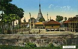
Taungoo (Burmese: တောင်ငူမြို့; MLCTS: taung ngu mrui., pronounced [tàʊɴŋù mjo̰]; S'gaw Karen: တီအူ; also spelled Toungoo) is a district-level city in the Bago Region of Myanmar, 220 km from Yangon, towards the north-eastern end of the division, with mountain ranges to the east and west. The main industry is in forestry products, with teak and other hardwoods extracted from the mountains. The city is known for its areca palms, to the extent that a Burmese proverb for unexpected good fortune is equated to a "betel lover winning a trip to Taungoo".
The city is famous in Burmese history for the Toungoo dynasty which ruled the country for over 200 years between the 16th and 18th centuries. Taungoo was the capital of Burma in 1510–1539 and 1551–1552.
Kaytumadi new city (new city of Taungoo) is the central command of the southern command division region of Armed Forces (Tatmadaw). Hanthawaddy United Football Club is based in Taungoo.
Names
The classical Pali name of Taungoo is Ketumadi (ကေတုမဒီ;Pali: Ketumadi), which translates to "possessed of the royal standard."[2]
History
Taungoo was founded in 1279 in the waning days of Pagan as part of frontier expansion southwards. After the fall of Pagan Empire in 1287, Taungoo came under the rule of Myinsaing Kingdom and later Pinya Kingdom. In 1358, Taungoo successfully revolted and became independent until 1367 when it became a nominal part of the Ava Kingdom. Its rulers retained a large degree of autonomy, playing larger Ava and Hanthawaddy kingdoms against each other. In 1470, Ava put down another rebellion and made Sithu Kyawhtin, the general who defeated the rebellion, governor. Sithu Kyawhtin's grandson Mingyi Nyo became governor of Taungoo in 1485. Under Mingyi Nyo's leadership, the principality grew powerful. In October 1510, Mingyi Nyo formally broke away from Ava and founded the Taungoo Kingdom.[3]
Mingyi Nyo's successors Tabinshwehti and Bayinnaung went on to found the largest empire in the history of south-east Asia.[4] Taungoo's stint as capital was short-lived, however. Tabinshwehti moved the kingdom's capital to Pegu (Bago) in 1539. The city briefly again became capital of a rebellion in 1599 when viceroy Minye Thihathu II of Taungoo declared himself king. In December 1599, Taungoo's forces in collaboration with the Arakanese armies aided by Portuguese mercenaries, sacked Pegu. The rebellious city state remained independent for another 10 years when Natshinnaung ascended the Taungoo throne in 1609. In the following year, King Anaukpetlun captured Taungoo and ended the city's long line of rulers.[5] Although few visible historic remains survive, all four sides of the brick city wall remain from the dynastic period, with the exception of the part of the southern wall. The 9.6 m wide moat has largely dried up, except for a section on the eastern side, which is still maintained.
By the mid-19th century, Taungoo was governed by a local governor appointed by the Konbaung kings. The Taungoo District consisted of 52 wards, including today's Pyinmana (and Naypyidaw) regions. The district was cut in half after the Second Anglo-Burmese War. The British annexed the southern half, including the city of Taungoo while the northern portion, including Pyinmana and Ela, remained under Burmese control.[6]
In 1940, the British Royal Air Force built an airfield north of the town, which from August 1941 through February 1942 served as a training and support base for the 1st American Volunteer Group, popularly known as the Flying Tigers.
Taungoo celebrated its 500th birthday on 16 October 2010, by reconstructing and renovating many city attractions.[3]
Climate
Taungoo has a tropical savanna climate (Köppen climate classification Aw) bordering on a tropical monsoon climate (Köppen climate classification Am). Temperatures are hot throughout the year, and the months before the monsoon (March–May) are especially hot with average maximum temperatures exceeding 35 °C (95 °F). There is a winter dry season (November–March) and a summer wet season (April–October).
| Climate data for Taungoo | |||||||||||||
|---|---|---|---|---|---|---|---|---|---|---|---|---|---|
| Month | Jan | Feb | Mar | Apr | May | Jun | Jul | Aug | Sep | Oct | Nov | Dec | Year |
| Average high °C (°F) | 30.7 (87.3) |
34.0 (93.2) |
36.6 (97.9) |
37.9 (100.2) |
35.2 (95.4) |
31.2 (88.2) |
30.1 (86.2) |
30.0 (86) |
31.6 (88.9) |
32.4 (90.3) |
31.8 (89.2) |
30.2 (86.4) |
32.6 (90.8) |
| Average low °C (°F) | 14.9 (58.8) |
16.1 (61) |
20.3 (68.5) |
24.1 (75.4) |
24.6 (76.3) |
23.7 (74.7) |
23.6 (74.5) |
23.4 (74.1) |
23.6 (74.5) |
23.0 (73.4) |
20.4 (68.7) |
16.4 (61.5) |
21.2 (70.1) |
| Average precipitation mm (inches) | 7 (0.28) |
1 (0.04) |
4 (0.16) |
430 (16.93) |
193 (7.6) |
376 (14.8) |
419 (16.5) |
449 (17.68) |
277 (10.91) |
157 (6.18) |
44 (1.73) |
13 (0.51) |
2,370 (93.32) |
| Source: HKO (1961–1990)[7] | |||||||||||||
Administration
- Taungoo District (The district combined have a total of 6 townships. They are Taungoo, Phyu, Yedashe, Tantabin, Kyaukkyi, Oktwin)
- Taungoo Township
- Taungoo Ward – 23 Wards
- Taungoo Municipal
- District and Township Immigration Dept
- Myanmar Timber Enterprise
- Finance and Tax Dept
- Civil Engineering Dept
- District and Township Education Dept
- Health Dept
- District and Township Forestry Dept
- MPPE
- Taungoo Correctional Dept. Taungoo Prison
- Taungoo Quarry Camp
- Taungoo Post Office
- Taungoo TeleCom station
- Myanmar Television Sub-station
- Myawady Television Sub-station
- Union Solidarity and Development Association
- Myanmar Maternal Children’s Welfare Association
- Myanmar Women Affair Federation
- Division 5 Railways Office
- Taungoo Township and District Courts
- "Maha Myittar" Education Foundation
Emergency
- No.1 Police Station Taungoo
- No.2 Police Station Taungoo
- No.3 Police Station Taungoo
- Taungoo District Police Force
- Taungoo Township Police Force
- Division 5 Railways Police Force, Taungoo
- Taungoo Motor Vehicle Police Station
- Taungoo Fire Station Command (1 Support Vehicle)
- Taungoo Township Fire Station No.1 (3 Engines)
- Taungoo Township Fire Station No.2 (2 Engines)
- Myanmar Red Cross Society, Taungoo – Ambulance
- Electrical Department
- Taungoo Weather Station
Military
- Southern Command – Kaytumadi new city
- Taungoo Air Force Base HQ
- No.47 Helicopters Squadron
- Amoury Division – Oak Twin
- Artillery Division – Oak Twin
- Police Battalion, Taungoo – Training School
- No.(3) Field Medical Battalion
Attractions
- Shwe San Taw Pagoda (Build by King Min Gyi Nyo)
- Kaung Hmu Taw Pagoda
- Mya See Gone Pagoda
- Myat Saw Nyi Naung Pagoda
- Kaylazarti Pagoda (Build by King Bayintnaung)
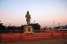
- Statue of King Bayintnaung
- Statue of King Min Gyi Nyo
- Statue of Bogyoke Aung San
- Kantawgyi Garden
- Royal Kaytumadi Hotel (Design by Old Taungoo)
- Taungoo Kyone
- Taungoo Gyi old city
- Taungoo Nge old city
- Dwaryarwadi old city
- Danyawadi old city
- Phoe Kyar Elephant garden
- Pathi Cheek
- Sittaung River
- Naw Bu Paw Mountain (Kayin State, over sea level 4,824 ft)
- Than Daung Kyi Mountain city
Investigative bodies
- Military Intelligence No.3 (MI)
- Special Intelligence (Special Branch) SB
- Bureau of special investigations (BSI)
- Special Police Force
- Narcotic
Demographics
The population of Taungoo in the 2014 census was 108,569; in the 1983 census it was 65,851.[1]
The Bamar (Burmans) make up the majority with a significant Kayin (Karen) population on the eastern side of the city. The Chinese, Indians, Shan and Kayah people make up the rest.
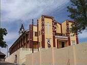
The majority of residents are Theravada Buddhists, followed by Baptist and Roman Catholic Christians. Taungoo is home to a number of Karen Christian association headquarters and fifteen churches.
Transport

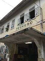
The main transport options to Taungoo is rail and motorways. The Taungoo railway station is on the main north line of Myanmar Railways, and the Taungoo Highway bus station is served by domestic bus lines.
Taungoo Airport is the area's only airport. It is a military-only airbase.
Intra-city transport is mainly through a circular railway line which serves around the Taungoo District and bus lines, which serve downtown, and suburban areas:
- Gandawin Express Bus
- Yoma Express Bus
- Zay Yar Shwe Pyi Express Bus
- Say Taman Express Bus
- Sein Myittar Express Bus
- Shwe Man Thu Express Bus
- Taw Win Express Bus (Naypyitaw)
- Tabin Shwehtee Express Bus
- Mya Yadana Express Bus (Mandalay)
- Shwe Lonn Pyan Express Bus (Taungyi)
- Pyu Min Thar (Pyay)
There are two main road bridges: over the Sittaung River and the Kaphaung River.
Education
High schools
Taungoo has eleven high schools: see List of high schools in Taungoo.
Public universities
Nursing and midwifery schools
- Taungoo Nursing Training School
- Taungoo Midwifery Training School
Divinity schools
- Paku Divinity School
- St. Peter's Bible School (Anglican)
Healthcare
- Taungoo General Hospital
- Taungoo Railways Hospital
- Taungoo Traditional Hospital
- Defence Services General Hospital
- Thaw Thee Kho Hospital
- Kaytu Hospital
- Royal Hospital
Major sites

- Thargaya Elephant Camp
- Kandawggyi Garden
- Kaytumaddy Garden
- Kaphaung Creek Bridge
- Sittaung Bridge
- Electronic Library
- Taungoo Gym
- Taungoo Stadium
- Kha Baung Hall
- Taungoo Municipal Market
- Taungoo Market
- Bayinnaung Market
- Kayinmazay Market
- 3D cinema
- Statue of Min Gyi Nyo
- Statue of Ba Yint Naung
- Statue of Bogoke Aung San
- Mingalar 3D Cinema
Pagodas
- Shwesandaw Pagoda
- Myasigon Pagoda
- Kaung Mhu Daw Pagoda
- Myat-Saw Nyi Naung Pagoda
- Ma Har Mu Ni Kay La Zar Ti Pagoda
- Nann Taw Oo Pagoda
- See Gone Gyi Pagoda (Old Taungoo)
- Mya Lane Da Pagoda (Old Taungoo)
Hotels
- Royal Kaytumadi Hotel
- Pan Swe Taw Hotel
- Amazing Kaytu Hotel
- Ngwe Saung Hotel
- Pathi Hotel
- Globel Grace Hotel
- Myanmar Beauty Hotel 1
- Myanmar Beauty Hotel 2
- Pyi Taw Win Hotel
- Mother House Hotel
- Yoma Hotel
- Golden Guest Hotel
- Shan Min Thar Hotel
- Naung Yoe Hotel
Notable residents
- Dr. Saw Durmay (Po Min) (fl. 1928), president of Loyal Karen Association of Burma-India, owner of white elephant and descendant of Karen chief priest[8][9]
- Ringo aka Maung Maung Lwin, singer, composer, and guitarist[10]
- Naw Li Zar, singer and composer[11]
- Saw Say Wah, chairman of Eastern Bago Division Anti-Drug Association and retired chief of police (deputy-director)[12]
- Soe Pyae Thazin, actress
- Kyar Pouk, Singer
- Sin Pouk, Singer
- Yin Go, Singer
Media
- MTV or MTV1 – broadcasts in Burmese language.
- MTV2 – broadcast in Burmese language and some local languages
- MTV4 – 24-hour sport channel. (pay TV)
- MTV3 – broadcasts in Thai, Khmer, Vietnamese and English. (pay TV)
- MRTV – broadcasts in Burmese, Arakanese, Shan, Karen, Kachin, Kayah, Chin, Mon and English
- MWD 1,2
- MRTV3
- The Mirror (Burmese: ကြေးမုံ)(Burmese: ေၾကးမံု-Kyehmonn) – state-run daily (newspaper)
- The Voice (newspaper)
- Eleven (newspaper)
- 7Days (newspaper)
- The New Light of Myanmar (Burmese: Myanma A-lin) – English and Burmese language (newspaper)
- The Myanmar Times (Burmese: Myanma Taing) – private-run English-language weekly (newspaper)
- Myanmar Radio National Service (Radio)
- VOA (Radio)
- BBC (Radio)
- Myanmar Teleport (ISP)
- Information Technology Central Services (ITCS)-(ISP)
- Myanmar Post and Telecommunication (MPT)- (ISP)
- Telenor – Norwegian mobile operator
- Mandalay FM
- Shwe FM
- Channel 7 – Digital broadcasting free-to-air channel
- MRTV 4 – Digital and analogue free-to-air channel
Gallery


References
- 1 2 "Myanmar". City Population. Retrieved 10 May 2018.
- ↑ The Baptist Missionary Magazine. 1856.
- 1 2 Shwe Yinnma Oo (2010-08-02). "Taungoo prepares for 500th birthday". The Myanmar Times. Archived from the original on 4 August 2010.
- ↑ Victor B Lieberman (2003). Strange Parallels: Southeast Asia in Global Context, c. 800-1830, volume 1, Integration on the Mainland. Cambridge University Press. pp. 150–154.
- ↑ Maung Htin Aung (1967). A History of Burma. New York and London: Cambridge University Press. p. 140.
- ↑ Sir James George Scott, John Percy Hardiman (1901). Gazetteer of Upper Burma and the Shan States, Part 2. 3. Printed by the superintendent, Government printing, Burma. p. 374.
- ↑ "Climatological Information for Taungoo, Myanmar". Hong Kong Observatory. Retrieved January 12, 2013.
- ↑ https://web.archive.org/web/20130601062357/http://www.elephant.se/location2.php?location_id=1677&show=1. Archived from the original on 1 June 2013. Retrieved 6 July 2012. Missing or empty
|title=(help) - ↑ San C. Po, Dr. (1928). "VII Karen Celebrities". Burma and the Karens. London: Elliott Stock.
- ↑ https://web.archive.org/web/20111125072352/http://myanmarmp3.net/artist.aspx?ArtID=107. Archived from the original on 25 November 2011. Retrieved 6 July 2012. Missing or empty
|title=(help) - ↑ https://web.archive.org/web/20101125114814/http://myanmarmp3.net/artist.aspx?ArtID=357. Archived from the original on 25 November 2010. Retrieved 6 July 2012. Missing or empty
|title=(help) - ↑ https://web.archive.org/web/20130306003732/http://www.mizzima.com/political-pro/new-parties/kpp.html. Archived from the original on 6 March 2013. Retrieved 12 March 2013. Missing or empty
|title=(help)
External links
- https://web.archive.org/web/20111005202137/http://www.most.gov.mm/taungootu/index.php
- https://web.archive.org/web/20110719005152/http://www.ucsy.edu.mm/taungoocu/
- San C. Po, Dr. (1928). Burma and the Karens. London: Elliott Stock.
- "Central Myanmar Mission". Seventh-day Adventist Online Yearbook.
- "Diocese: Toungoo". Anglican Communion.
- "Diocese of Taungngu, Myanmar". GCatholic.org.
Taungoo | ||
| Preceded by Ava |
Capital of Burma 16 October 1510 – January 1539 |
Succeeded by Bago |
| Preceded by Bago |
Capital of Burma 11 January 1551 – 12 March 1552 |
Succeeded by Bago |
Coordinates: 18°56′N 96°26′E / 18.933°N 96.433°E
Capital: Bago | ||||||
| East Bago Region |
|   | ||||
| West Bago Region |
| |||||
| Main cities and towns | ||||||