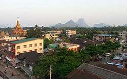
Hpa-An
| Hpa-An ဘားအံမြို့ ဖးအါဝ့ၢ်ဖိ | |
|---|---|
| Town | |
 | |
 Hpa-An Location in Myanmar (Burma) | |
| Coordinates: 16°53′26″N 97°38′0″E / 16.89056°N 97.63333°ECoordinates: 16°53′26″N 97°38′0″E / 16.89056°N 97.63333°E | |
| Country |
|
| Division |
|
| District | Hpa-an District |
| Township | Hpa-an Township |
| Population (2014 census) | 421,525 |
| • Ethnicities | Karen (Majority), Pwo, Mon, Bamar, Pa’O Karenni [Kayan] |
| • Religions | Theravada Buddhism and Christianity |
| Time zone | UTC+6.30 (MMT) |
| Area code(s) | 58[1] |
Hpa-An (S'gaw Karen: ဖးအါ, Burmese: ဘားအံမြို့, pronounced [pʰə ʔàɴ mjo̰] also spelled Pa-An) is the capital of Kayin State (also known as Karen State), Myanmar (Burma). The population of Hpa-An as of the 2014 census is 421,575. Most of the people in Hpa-An are of the Karen ethnic group.
Climate
Hpa-An has a tropical monsoon climate (Köppen climate classification Am). Temperatures are very warm throughout the year, although maximum temperatures are somewhat depressed in the monsoon season due to heavy cloud and rain. There is a winter dry season (November–April) and a summer wet season (May–October). Torrential rain falls from June to August, with over 1,100 millimetres (43 in) falling in August alone.
| Climate data for Hpa-An | |||||||||||||
|---|---|---|---|---|---|---|---|---|---|---|---|---|---|
| Month | Jan | Feb | Mar | Apr | May | Jun | Jul | Aug | Sep | Oct | Nov | Dec | Year |
| Average high °C (°F) | 30.5 (86.9) |
31.9 (89.4) |
33.4 (92.1) |
33.7 (92.7) |
31.3 (88.3) |
28.6 (83.5) |
27.9 (82.2) |
27.6 (81.7) |
28.4 (83.1) |
30.9 (87.6) |
31.3 (88.3) |
31.2 (88.2) |
30.6 (87) |
| Average low °C (°F) | 17.8 (64) |
18.9 (66) |
21.9 (71.4) |
24.5 (76.1) |
24.5 (76.1) |
23.7 (74.7) |
23.3 (73.9) |
23.4 (74.1) |
23.6 (74.5) |
23.5 (74.3) |
21.6 (70.9) |
18.7 (65.7) |
22.1 (71.8) |
| Average precipitation mm (inches) | 4 (0.16) |
5 (0.2) |
6 (0.24) |
42 (1.65) |
412 (16.22) |
875 (34.45) |
1,043 (41.06) |
1,134 (44.65) |
578 (22.76) |
208 (8.19) |
30 (1.18) |
8 (0.31) |
4,345 (171.07) |
| Source: NOAA (1961-1990) [2] | |||||||||||||
Transport
Air
Hpa-An is linked to Yangon, Mawlamyine and Hpapun by air.
Buses
There are exoress buses from Hpa-An to Yangon, Mawlamyine, border trade of Myawaddy and other towns.
Population history
- 1953: 4,100
- 1983: 41,500
Education
- Computer University, Hpa-An
- Hpa-An Education College
- Hpa-An Nursing Training School
- Hpa-An University
- Technological University, Hpa-An
Religion
The majority of residents are Theravada Buddhists, followed by Baptist, Anglican and Roman Catholic Christians.
Sights


Kayin State Cultural Museum is located in Hpa-An. The Zwegabin Hill is an attractive place for visitors. Kyaukkalatt (Kyauk Kalat Monastery) and Kawtgon Cave (or Kawgoon Cave) is also a place of interest. There is amazing Kyone-Htaw waterfall near Hpa-an and it will take 2 hours driving from Hpa-an. And, there is wonderful Saddan Cave which is the biggest and longest cave in Kayin-State. [3]
Health care
- Hpa-An General Hospital
- Taung Kalay Military Hospital
Sports
Football
Zwegabin United FC founded in 2010, is based in Hpa-An. The club is competing in Myanmar National League.
Trekking and hiking

Mount Zwegabin is around 8.5km south of Hpa An. It is famous among tourists for its stunning view and beautiful green nature.[4]
At Bayint Nyi cave, a new climbing site has been developed primarily under the guidance of Andrew Riley & Katie Riley, as well as early support from The Technical Climbing Club of Myanmar (TCCM). This is an ongoing project having started in 2015 with support mostly coming from a growing number of expats in Yangon who belong to Myanmar Rock Community (MRC). The club is now beginning to attract interest from local people which is helping fuel a growing interest in the sport of rock climbing around Myanmar. [5] [6]
References
- ↑ "Myanmar Area Codes". Retrieved 2009-04-10.
- ↑ "Hpa-An Climate Normals 1961-1990". National Oceanic and Atmospheric Administration. Retrieved January 12, 2013.
- ↑ http://myanmarcaves.wikidot.com/saddan-hai-sin-caves-hpa-an
- ↑ "The Ultimate Backpacking Experience". 2016-08-21. Retrieved 2018-05-30.
- ↑ https://www.facebook.com/climbmyanmar/?ref=ts&fref=ts
- ↑ https://www.mountainproject.com/v/hpa-an/110521642
External links
Capital: Hpa-an | ||
| Hpa-an District | 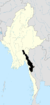 | |
| Hpapun District | ||
| Kawkareik District | ||
| Myawaddy District | ||
| Cities and towns | ||