Kasese
| Kasese | |
|---|---|
 | |
 Kasese Location in Uganda | |
| Coordinates: 0°11′12″N 30°05′17″E / 0.18667°N 30.08806°E | |
| Country |
|
| Region | Western Region |
| Sub-region | Rwenzururu region |
| District | Kasese District |
| Elevation | 3,000 ft (1,000 m) |
| Population (2014 Census) | |
| • Total | 101,679[1] |
| Climate | Aw |
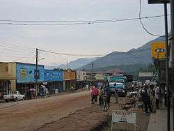
Kasese is a town north of Lake George in the Western Region of Uganda. It originally grew around the copper mine at Kilembe, while attention later turned to cobalt mining. It is the chief town of Kasese District, and the district headquarters are located there. Kasese is also the largest town in the Rwenzururu region. Charles Mumbere, the Omusinga of Rwenzururu, maintains a palace in the town.
Location
Kasese is at the western end of the Uganda Railway to Kampala and Tororo and is home to Kasese Airport. The city is near the Rwenzori Mountains and Queen Elizabeth National Park. Kasese is approximately 345 kilometres (214 mi), by road, west of Kampala, Uganda's capital and largest city.[2] This is about 61 kilometres (38 mi), by road, north-east of Mpondwe, the border town at the international border between Uganda and the Democratic Republic of the Congo (DRC).[3] The coordinates of Kasese are 0°11'12.0"N, 30°05'17.0"E (Latitude:0.186667; Longitude:30.088050).[4]
Population
In August 2014, the Uganda Bureau of Statistics estimated the population of the town at 101,679.[1]
Population dynamics

Kasese town is one of the fastest growing municipalities in Uganda. The reasons for this rapid population growth include:[5]
- Increased tourism - Kasese is the gateway to Queen Elizabeth National Park, one of the most popular in Uganda, and the Rwenzori National Park.[6]
- Kilembe Mines employs a large number of workers; over 3,000 as of January 2015.[7][8]
- Hima Cement Limited is another big employer located in Hima, approximately 24 kilometres (15 mi), by road, north of Kasese.[9]
- Increased trade with the eastern districts of the DRC. The border town of Mpondwe is only 61 kilometres (38 mi) south-west of Kasese.[3]
Industry
Kasese Cobalt Company Limited (KCCL), located on the road from Kasese to Rubirizi just south of the central business district of Kasese, extracts cobalt from the sludge left after copper is extracted from the raw ore.[7]
Points of interest
The following points of interest lie within the town or close to its edges:
- headquarters of Kasese District
- offices of Kasese town council
- Kasese central market
- branch of the National Social Security Fund
- Hima Cement Limited
- Kasese Airport
- Kilembe Cobalt Company Limited
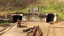
- Kilembe Mines - Extraction of copper. Maintains a private hospital and a 5 megawatt mini-hydropower plant, Mubuku I Power Station, that supplies the town of Kasese.[10]
- Kilembe Mines Hospital - A 200-bed community hospital administered by Kilembe Mines Limited.[11][12][13]
See also
References
- 1 2 UBOS (27 August 2014). "The Population of The Regions of the Republic of Uganda And All Cities And Towns of More Than 15,000 Inhabitants". Citypopulation.de Quoting Uganda Bureau of Statistics (UBOS). Retrieved 22 February 2015.
- ↑ GFC (13 May 2016). "Distance between Uganda Post Office, Kampala Road, Kampala, Central Region, Uganda and Kasese Post Office, Rwenzori Road, Kasese, Western Region, Uganda". Globefeed.com (GFC). Retrieved 13 May 2016.
- 1 2 GFC (13 May 2014). "Distance Between Kasese Post Office, Rwenzori Road, Kasese, Western Region, Uganda and Mpondwe Customs Police Station, Bukonjo, Western Region, Uganda". Globefeed.com (GFC). Retrieved 13 May 2014.
- ↑ Google (1 July 2015). "Location of Kasese at Google Maps" (Map). Google Maps. Google. Retrieved 1 July 2015.
- ↑ Alex Kwatampora Binego (10 January 2014). "Causes of River Nyamambwa floods". New Vision. Kampala. Retrieved 13 May 2016.
- ↑ UWO (13 May 2016). "Rwenzori Mountains National Park: Tourism: "Kasese, 437 km west of Uganda's capital Kampala, is the gateway to the park"". Entebbe: Ugandawildlife.org (UWO). Archived from the original on 22 May 2016. Retrieved 13 May 2016.
- 1 2 Mugira, Fredrick (31 January 2015). "Chinese consortium to revive Uganda's copper mines". China Africa Reporting. Retrieved 13 May 2016.
- ↑ Khisa, Isaac (10 January 2015). "Copper production to resume at Kilembe". The EastAfrican. Nairobi. Retrieved 13 May 2016.
- ↑ GFC (13 May 2016). "Distance between Kasese, Western Region, Uganda and Hima, Western Region, Uganda". Globefeed.com (GFC). Retrieved 13 May 2016.
- ↑ Asiimwe, Wilson (7 June 2014). "Kilembe mines rehabilitation starts". New Vision. Retrieved 13 September 2015.
- ↑ Enid Ninsiima, and Thembo Kahungu Misairi (13 September 2015). "Four killed as floods sweep Kilembe Mines hospital". Daily Monitor. Kampala. Retrieved 1 July 2015.
- ↑ Thawite, John (4 June 2013). "Kilembe Hospital re-opens". New Vision. Kampala. Retrieved 13 September 2015.
- ↑ John Thawite, and Taddeo Bwambale (8 May 2014). "Five perish as fresh floods hit Kasese". New Vision. Kampala. Retrieved 13 September 2015.
External links
| Wikivoyage has a travel guide for Kasese. |
Capital: Kasese | ||
| Towns and villages | 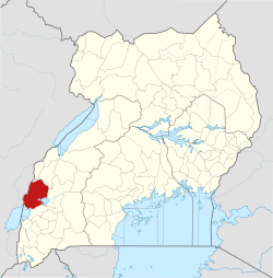 | |
| Economy |
| |
| Transport | ||
| Energy |
| |
| Notable landmarks | ||
| Health | ||
| Notable people | ||