Kallanai Dam
| Kallanai Dam | |
|---|---|
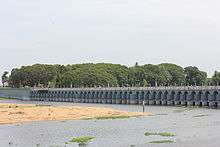 The present structure of the dam | |
 Location of Kallanai Dam in Tamil Nadu | |
| Official name | Kallanai Dam |
| Location | Tiruchirappalli District |
| Coordinates | 10°49′49″N 78°49′08″E / 10.830166°N 78.818784°ECoordinates: 10°49′49″N 78°49′08″E / 10.830166°N 78.818784°E |
| Construction began | 2nd Century AD |
| Built by | Karikala |
| Dam and spillways | |
| Type of dam | Composite Dam and Reservoir |
| Impounds | Cauvery |
| Length | 0.329 km (1,079 ft) |
| Width (base) | 20 m (66 ft) |
Kallanai (also known as the Grand Anicut , Tamil : கல்லணை) is an ancient dam, which is built (in running water) across the Kaveri river in Tiruchirappalli District in the state of Tamil Nadu in India.[1] Located at a distance of 15 km from Tiruchirappalli, the dam was originally constructed by the Chola king Karikalan in 2nd century AD. It is located on Kaveri river approximately 20 KM from Trichy city, the dam falls under Thanjavur district .[2][3] and is the fourth-oldest water-diversion or water-regulator structures in the world and the oldest in India which is still in use.
History
The dam was originally built by King Karikalan of the Chola Dynasty in the 2nd century AD. The dam is located on the River Kaveri, approximately 20km from the city of Tiruchirapalli.The idea behind the construction of the dam was to divert the river to the delta districts thereby boosting irrigation.[4] The dam was re-modeled by the British during the 19th century. In 1804, Captain Caldwell, a military engineer, was appointed by the British to make a study on the Kaveri river and promote irrigation for the delta region.[5] He found that a large amount of water passed onto the Kollidam leaving behind a small volume for irrigation purposes.[5] Caldwell initially proposed a solution by raising the dam and hence raised the dam stones to a height of 69 centimetres (27 in), thus increasing the capacity of the dam.[4] Following this, Major Sim proposed the idea of undersluices across the river with outlets leading to the Kollidam River (Coleroon) thus preventing formation of silt.[4] The Lower Anaicut built by Sir Arthur Cotton in 19th century CE across Coleroon, the major tributary of Cauvery, is said to be a replicated structure of Kallanai.[4]
Geography
The Kaveri river splits into two at a point 20 miles (32 km) west of Kallanai. The two rivers form the island of Srirangam before joining at Kallanai. The northern channel is called the Kollidam (Coleroon); the other retains the name Kaveri, and empties into the Bay of Bengal at Poompuhar. On the seaward face of its delta are the seaports of Nagapattinam and Karaikal.[6]
Description
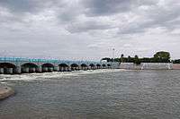
The purpose of the Kallanai was to divert the waters of the Kaveri across the fertile delta region for irrigation via canals and to its northern delta branch Kollidam/Coleroon. Down stream of the barrage, the river Kaveri splits into four streams known as Kollidam Aru, Kaviri, Vennaru and Puthu Aru. However, the flood waters can be allowed, by opening the barrage/anaicut gates, to pass through the other three delta branches also to join the sea.[7] It is constructed from unhewn stone spanning the Kaviri and is 329 m (1,079 ft) long, 20 m (66 ft) wide and 5.4 m (18 ft) high.[8] The dam is still in excellent condition, and supplied a model to later engineers, including Sir Arthur Cotton's 19th-century dam across the Kollidam, the major tributary of the Kaveri.[9] The area irrigated by the ancient irrigation network is about 69,000 acres (28,000 ha). By the early 20th century, the irrigated area had been increased to about one million acres (400,000 ha).[10]
The Delta farmers of Tamil Nadu have demanded that the Tamil Nadu government honour Karikala Cholan, who built the Kallanai.
Gallery
 Engineering Wonder of Karikalan's period.
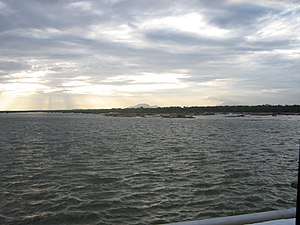 Kaveri river over which Kallanai was built.
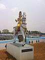
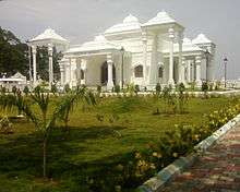 Karikal Cholan memorial (Karikal Cholan Manimandpam)
.jpg) Bronze statue of Karikal Cholan king
Bronze statue of Karikal Cholan king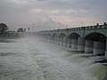 Kallanai dam, Trichy
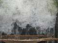 Fishing in the sluices, Kallanai dam, Trichy
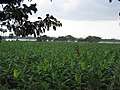 Banana fields near Kallanai dam
 Another view, Kallanai dam
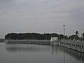 Kallanai dam
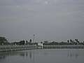 Kallanai dam
See also
References
- ↑ "The world's oldest dams still in use". Retrieved 24 August 2016.
- ↑ "Flowing waters for fertile fields". The Hindu. India. 29 August 2011.
- ↑ Singh, Vijay P.; Ram Narayan Yadava (2003). Water Resources System Operation: Proceedings of the International Conference on Water and Environment. Allied Publishers. p. 508. ISBN 81-7764-548-X.
- 1 2 3 4 Syed Muthahar Saqaf (10 March 2013). "A rock solid dam that has survived 1800 years". The Hindu. Retrieved 13 November 2013.
- 1 2 Skempton 2002, p. 114.
- ↑ Wiebe E. Bijker (19 September 2006). "Dikes and Dams, Thick with Politics". Maastricht University. Retrieved 7 November 2011.
- ↑ "Grand Anicut A00677". WRIS, India. Retrieved 7 November 2016.
- ↑ "Places to visit". IIM-Trichy, India. Retrieved 7 November 2011.
- ↑ Govindasamy Agoramoorthy; Sunitha chaudhary; Minna J. HSU. "The Check-Dam Route to Mitigate India's Water Shortages" (PDF). Law library — University of New Mexico. Archived from the original (PDF) on 20 July 2013. Retrieved 7 November 2011.
- ↑ "Fit case for World Heritage status". The Hindu. Trichy, India. 10 September 2007.
Bibliography
| Wikimedia Commons has media related to Grand Anicut. |
- Skempton, A. W. (2002). A Biographical Dictionary of Civil Engineers in Great Britain and Ireland: 1500-1830. Thomas Telford. ISBN 978-0-7277-2939-2.
- Rita (2011). Inventive Indians. Westland. ISBN 978-93-80658-03-2.
Further reading
- Rahman, Abdur; Project of History of Indian Science, Philosophy, and Culture (1999). History of Indian Science, Technology and Culture: Ad 1000-1800. Oxford University Press India. ISBN 978-0-19-564652-8.