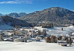
Jungholz
| Jungholz | ||
|---|---|---|
 | ||
| ||
 Jungholz Location within Austria
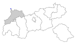
Location of Jungholz within Tyrol
| ||
| Coordinates: 47°34′25″N 10°26′50″E / 47.57361°N 10.44722°ECoordinates: 47°34′25″N 10°26′50″E / 47.57361°N 10.44722°E | ||
| Country | Austria | |
| State | Tyrol | |
| District | Reutte | |
| Government | ||
| • Mayor | Karina Konrad | |
| Area | ||
| • Total | 7 km2 (3 sq mi) | |
| Elevation | 1,054 m (3,458 ft) | |
| Population (1 January 2016)[1] | ||
| • Total | 285 | |
| • Density | 41/km2 (110/sq mi) | |
| Time zone | UTC+1 (CET) | |
| • Summer (DST) | UTC+2 (CEST) | |
| Postal codes |
6691 (Austria) 87491 (Germany) | |
| Area code | 05676 | |
| Vehicle registration | RE | |
| Website |
www.jungholz. tirol.gv.at | |

Jungholz is a town in the district of Reutte in the Austrian state of Tyrol that is only accessible via Germany. The lack of a road connection to anywhere else in Austria led to Jungholz being included in the German customs area until Austria joined the EU in 1995. Letters to Jungholz can be addressed with either a German or an Austrian postcode (D-87491 and A-6691, respectively).
Quadripoint

Jungholz forms an exclave of Austria that is connected to the rest of Austria by a single point, which is the summit of the mountain Sorgschrofen (1,636 m, 5,367 ft). As well as housing border post number 110 on the normal international border between Tyrol and Bavaria, a second border starts and, having gone round Jungholz, ends there. There are thus borders extending in four directions from the summit, called a quadripoint. Two Austrian (Tyrolian, Reutte) and two German (Bavarian, Oberallgäu) municipalities meet at that point, starting with Jungholz and continuing clockwise:
- Jungholz (Austrian, north)
- Pfronten (German, east)
- Schattwald (Austrian, south)
- Bad Hindelang (German, west)
See also
References
External links
- The boundary cross at Jungholz
- Jungholz's official website (in German only)
| Wikimedia Commons has media related to Jungholz. |