Bichlbach
| Bichlbach | ||
|---|---|---|
 | ||
| ||
 Bichlbach Location within Austria | ||
| Coordinates: 47°25′15″N 10°47′29″E / 47.42083°N 10.79139°ECoordinates: 47°25′15″N 10°47′29″E / 47.42083°N 10.79139°E | ||
| Country | Austria | |
| State | Tyrol | |
| District | Reutte | |
| Government | ||
| • Mayor | Klaus Zirnhöld | |
| Area | ||
| • Total | 30.6 km2 (11.8 sq mi) | |
| Elevation | 1,079 m (3,540 ft) | |
| Population (1 January 2016)[1] | ||
| • Total | 756 | |
| • Density | 25/km2 (64/sq mi) | |
| Time zone | UTC+1 (CET) | |
| • Summer (DST) | UTC+2 (CEST) | |
| Postal code | 6621 | |
| Area code | 05674 | |
| Vehicle registration | RE | |
| Website |
www.riskommunal.net/ bichlbach | |

Bichlbach is a municipality in the district of Reutte in the Austrian state of Tyrol.
Geography
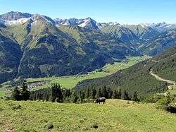
Bichlbach lies at an elevation of 1,079 m (AA) in the Zwischentoren, the valley that links the Ehrwald Basin with the Lech valley. Over the municipal territory runs the watershed between the Lech and Loisach. The municipality consists of three villages: the elongated Straßendorf of Bichlbach (1,079 m above sea level (AA), population: 550) and the two almost adjacent villages of Lähn (1,112 m above sea level (AA), pop: 225) and Wengle (1,083 m above sea level (AA), pop: 76; population figures as at 15 May 2001). Bichlbach is the base for an ascent of the Kohlbergspitze (2,202 m) on a waymarked path that takes around 3 hours.
Neighbouring municipalities
Places adjacent to Bichlbach | |
|---|---|

References
External links
| Wikimedia Commons has media related to Bichlbach. |
This article is issued from
Wikipedia.
The text is licensed under Creative Commons - Attribution - Sharealike.
Additional terms may apply for the media files.