Häselgehr
| Häselgehr | ||
|---|---|---|
 | ||
| ||
 Häselgehr Location within Austria | ||
| Coordinates: 47°18′30″N 10°29′30″E / 47.30833°N 10.49167°ECoordinates: 47°18′30″N 10°29′30″E / 47.30833°N 10.49167°E | ||
| Country | Austria | |
| State | Tyrol | |
| District | Reutte | |
| Government | ||
| • Mayor | Harald Friedle | |
| Area | ||
| • Total | 50.6 km2 (19.5 sq mi) | |
| Elevation | 1,006 m (3,301 ft) | |
| Population (1 January 2016)[1] | ||
| • Total | 659 | |
| • Density | 13/km2 (34/sq mi) | |
| Time zone | UTC+1 (CET) | |
| • Summer (DST) | UTC+2 (CEST) | |
| Postal code | 6651 | |
| Area code | 05634 | |
| Vehicle registration | RE | |
| Website |
www.haeselgehr. tirol.gv.at | |

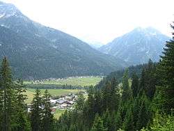
Häselgehr is a municipality in the district of Reutte in the Austrian state of Tyrol.
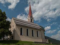
Häselgehr, church: katholische Pfarrkirche heilige Martin
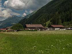
Gutschau, living houses with mountains in background
Geography
Häselgher lies in the upper valley of the Lech.
References
External links
| Wikimedia Commons has media related to Häselgehr. |
This article is issued from
Wikipedia.
The text is licensed under Creative Commons - Attribution - Sharealike.
Additional terms may apply for the media files.