Pfronten
| Pfronten | ||
|---|---|---|
| ||
 Pfronten Location of Pfronten within Ostallgäu district 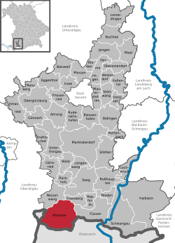 | ||
| Coordinates: 47°35′N 10°33′E / 47.583°N 10.550°ECoordinates: 47°35′N 10°33′E / 47.583°N 10.550°E | ||
| Country | Germany | |
| State | Bavaria | |
| Admin. region | Schwaben | |
| District | Ostallgäu | |
| Government | ||
| • Mayor | Josef Zeislmeier (SPD) | |
| Area | ||
| • Total | 62.22 km2 (24.02 sq mi) | |
| Elevation | 853 m (2,799 ft) | |
| Population (2017-12-31)[1] | ||
| • Total | 8,217 | |
| • Density | 130/km2 (340/sq mi) | |
| Time zone | CET/CEST (UTC+1/+2) | |
| Postal codes | 87459 | |
| Dialling codes | 08363 | |
| Vehicle registration | OAL | |
| Website | www.pfronten.de | |

Pfronten is a municipality in the district of Ostallgäu in Bavaria in Germany.
Geography
Pfronten is one of a total of 45 towns, markets and municipalities in the district of Ostallgäu.
Pfronten is located on the northern edge of the Allgäu Alps. The Vils flows through the municipal territory. It is situated at an altitude of 853 m above sea level. NN at the foot of Edelsberg, Kienberg, Breitenberg and Falkenstein. The highest point of the municipality is the summit of the Aggenstein (1986 m above sea level) on the Tyrolean border, which belongs to the Tannheim Mountains.
On the German side, neighbouring communities of Pfronten are the city of Füssen, the municipality of Eisenberg and the market of Nesselwang. In Austria, the small town of Vils and the Tannheim valley with the communities of Grän, Tannheim, Schattwald, Zöblen, Nesselwängle and Jungholz are located nearby.
The municipal territory consists of the districts of Bergpfronten and Steinachpfronten.
The settlements Berg, Dorf, Halden, Heitler, Kappel, Kreuzegg, Meilingen, Ösch, Rehbichel, Ried, Röfleuten, Steinach and Weißbach belong to the municipality of Pfronten. Since the late Middle Ages, all these places have surely formed a single parish. This is why we speak of the 13-village community of Pfronten.
- Views of Pfronten
 View of Pfronten
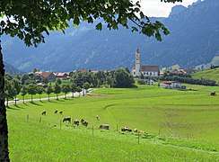 Pfronten-Berg
.jpg) Ruine Falkenstein
Ruine Falkenstein.jpg) Engetal with Aggenstein
Engetal with Aggenstein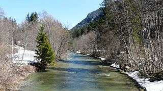 Vilstal
History
A Roman supply road led through Pfronten from the south to Cambodunum (today's Kempten).[2] However, a Roman settlement of the valley is not secured.
With the Christian provincial Romans, who remained in the Ostallgäu, pagan Alamanni gradually settled in. Around the year 800, the "Roman" language in the area was extinguished. In the Franconian-Carolingian region, the population was united with German language and Christianity.
From the early 14th century onwards, all of Pfronten belonged to the Augsburg Monastery, the secular territory of the Augsburg bishops. During the secularization of the monastery, Pfronten came to Bavaria in 1803. In 1818 the municipality was formed.
Transportation
The town is served by the Ausserfern Railway.
Famous people of Pfronten
- Johann Baptist Babel (1716–1799), sculptor
- Syrius Eberle (1844–1903), sculptor
Further reading
- Johann B. Doser: Pfronten in Vergangenheit und Gegenwart – Ein Beitr. zur Heimatkunde. Pfronten-Ried 1925
- Simone Haf, Alison Feller: Pfrontener Impressionen. Horb am Neckar 2002. ISBN 3-89570-791-0
- Ludwig Holzner: Geschichte der Gemeinde Pfronten. herausgegeben von der Gemeinde Pfronten 1956
- Anton H. Konrad, Annemarie Schröppel, Adolf Schröppel: Pfronten (Schwäbische Kunstdenkmale, 34). Weissenhorn 1986
- Pfrontener Bilderbogen 86. Pfronten 1986. ISBN 3-925407-03-0
- Annemarie Schröppel, Adolf Schröppel: Alt-Pfrontener Photoalbum. Pfronten 1984
- Annemarie Schröppel: Pfrontener Kirchen und Kapellen und ihre Pfarrer. Pfronten 2002
- Thaddäus Steiner/Bertold Pölcher/Gemeinde Pfronten (Hrsg.): Pfrontener Flurnamen. Pfronten 2010 ISBN 978-3-00-032977-7
External links
![]()
- Official website

- German Wikipedia article (in German)
References
- ↑ "Fortschreibung des Bevölkerungsstandes". Bayerisches Landesamt für Statistik und Datenverarbeitung (in German). September 2018.
- ↑ Richard Knussert, Das Füssener Land in früher Zeit, p. 40