Steeg, Tyrol
| Steeg | ||
|---|---|---|
 | ||
| ||
 Steeg Location within Austria | ||
| Coordinates: 47°14′33″N 10°17′40″E / 47.24250°N 10.29444°ECoordinates: 47°14′33″N 10°17′40″E / 47.24250°N 10.29444°E | ||
| Country | Austria | |
| State | Tyrol | |
| District | Reutte | |
| Government | ||
| • Mayor | Günther Walch | |
| Area | ||
| • Total | 68 km2 (26 sq mi) | |
| Elevation | 1,122 m (3,681 ft) | |
| Population (1 January 2016)[1] | ||
| • Total | 669 | |
| • Density | 9.8/km2 (25/sq mi) | |
| Time zone | UTC+1 (CET) | |
| • Summer (DST) | UTC+2 (CEST) | |
| Postal code | 6655 | |
| Area code | 05633 | |
| Vehicle registration | RE | |
| Website |
www.steeg. tirol.gv.at | |

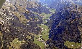
Steeg is a municipality in the district of Reutte in the Austrian state of Tyrol.
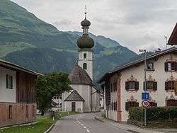
Steeg, church: katholische Pfarrkirche
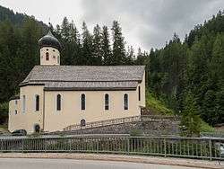
Hägerau, church (katholische Filialkirche heilige. Sebastian und Rochus) in the street
Geography
Steeg lies on the border to the state of Vorarlberg at the western edge of Tyrol.
References
| Wikimedia Commons has media related to Steeg (Tirol). |
This article is issued from
Wikipedia.
The text is licensed under Creative Commons - Attribution - Sharealike.
Additional terms may apply for the media files.