Jarabacoa
| Jarabacoa | |
|---|---|
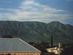 Central Range from Jarabacoa during the summer of 1997 | |
 Jarabacoa | |
| Coordinates: 19°7′12″N 70°38′24″W / 19.12000°N 70.64000°W | |
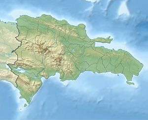
| Country |
|
| Province | La Vega |
| Area[1] | |
| • Total | 665.88 km2 (257.10 sq mi) |
| Elevation[2] | 529 m (1,736 ft) |
| Population (2012)[3] | |
| • Total | 69,855 |
| • Density | 100/km2 (270/sq mi) |
| • Urban | 32,585 |
| • Demonym | Jarabacoense |
| Distance to – Santo Domingo |
155 km |
| Municipal Districts |
2 |
| Climate | Af |
Jarabacoa is a town and the second largest municipality in La Vega Province, Dominican Republic.
History
Although many historical details are still unknown, it is very possible that the native people of the island inhabited the valley of Jarabacoa. It is assumed that the city's name was formed out of the words 'Jaraba' and 'Coa', meaning "Land of Waters" in the native language.[4] Some say that the Spanish conquistadors actually made it to Jarabacoa in their search for gold, but later abandoned the expedition. Some reasons include, resistance by the natives or as some say, because no large finds were ever made, although to this day gold can be washed from some of the many rivers.[5] Jarabacoa most likely belonged to the Chiefdom of Maguana making it part of the kingdom of Cibao. Necessary archaeological work has yet to take place, but it can be assumed that the natives lived in the area long before the arrival of Christopher Columbus.[6] It wasn't until 1805 that the area began being re-populated, during the Haitian invasion of the Cibao, when survivors from the massacres of Santiago de los Caballeros and La Vega escaped to the mountains of the Central Range and settled in the valley of Jarabacoa. In 1854, a military post was established and the town was formally founded. On September 27, 1858 the town was incorporated as a municipality.
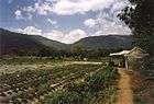
Geography and climate
.jpg)
Jarabacoa has a Tropical rainforest climate (Köppen climate classification Af ). Due to its tropical location and high elevation (about 525m above sea level), it has warm days and mild nights during most of the year, and temperate days and cool nights during a few winter months. Because of its mild temperatures, visitors have christened Jarabacoa as "The City of Everlasting Spring."
One of the main touristic attractions is the mountains and natural environment of the area due to its location in the center of the Central Range. It is also one of the main access to the Pico Duarte and the Ebano Verde Scientific Reserve. Jarabacoa has three large rivers, Baiguate, Jimenoa and the Yaque del Norte, the last two merge in the Confluencia, continuing on as the Yaque del Norte, the second largest river in the country.
The coldest temperature ever recorded was 7.1 °C (44.8 °F), on 24 February 2012.[7]
| Climate data for Jarabacoa (1971-2000) | |||||||||||||
|---|---|---|---|---|---|---|---|---|---|---|---|---|---|
| Month | Jan | Feb | Mar | Apr | May | Jun | Jul | Aug | Sep | Oct | Nov | Dec | Year |
| Record high °C (°F) | 34.4 (93.9) |
36.1 (97) |
35.6 (96.1) |
34.4 (93.9) |
35.0 (95) |
37.8 (100) |
38.3 (100.9) |
36.0 (96.8) |
36.0 (96.8) |
34.0 (93.2) |
33.0 (91.4) |
30.0 (86) |
38.3 (100.9) |
| Average high °C (°F) | 25.4 (77.7) |
26.0 (78.8) |
27.0 (80.6) |
27.6 (81.7) |
28.3 (82.9) |
29.8 (85.6) |
29.9 (85.8) |
30.0 (86) |
29.8 (85.6) |
29.0 (84.2) |
26.8 (80.2) |
25.3 (77.5) |
27.9 (82.2) |
| Daily mean °C (°F) | 20.0 (68) |
20.5 (68.9) |
21.3 (70.3) |
22.1 (71.8) |
23.0 (73.4) |
23.9 (75) |
24.0 (75.2) |
24.1 (75.4) |
23.9 (75) |
23.4 (74.1) |
22.0 (71.6) |
20.5 (68.9) |
22.4 (72.3) |
| Average low °C (°F) | 14.6 (58.3) |
14.9 (58.8) |
15.6 (60.1) |
16.6 (61.9) |
17.6 (63.7) |
17.9 (64.2) |
18.1 (64.6) |
18.2 (64.8) |
17.9 (64.2) |
17.7 (63.9) |
17.0 (62.6) |
15.6 (60.1) |
16.8 (62.3) |
| Record low °C (°F) | — | 7.1 (44.8) |
— | 9.0 (48.2) |
— | — | — | 12.4 (54.3) |
— | — | — | — | 7.1 (44.8) |
| Average rainfall mm (inches) | 130.6 (5.142) |
110.8 (4.362) |
112.3 (4.421) |
163.3 (6.429) |
210.7 (8.295) |
88.4 (3.48) |
89.4 (3.52) |
155.5 (6.122) |
137.2 (5.402) |
158.6 (6.244) |
194.2 (7.646) |
153.9 (6.059) |
1,704.9 (67.122) |
| Average rainy days | 11 | — | — | — | 14 | 7 | 8 | 9 | 10 | 13 | — | — | — |
| Source #1: National Bureau of Meteorology (ONAMET) [8] | |||||||||||||
| Source #2: Acqweather.com [9] | |||||||||||||
Economy
The local economy is based upon agriculture. It is known for its strawberries, coffee, pimento and ají pepper, the last two being grown in green houses. Jarabacoa it is also known for its wide variety of flowers.
Places of interest

- Rancho Olivier Bed and Breakfast. Historic Hotel since 1976. Olivier Family Owner.
- Thevenin Centro Canino Integral. Dachshund Kennel and Cocker Spaniel is a Beautiful Family Place.
- The forestry college "Universidad Agroforestal Fernando Arturo de Marino" http://uafam.edu.do/
- Colegio Salesiano, a salesian school with soccer and baseball fields, volleyball and basketball courts, academy, parroquial school, retreat center, medical dispensary.
- Monasterio de Santa María del Evangelio, Cistercian Monastery.
- Jimenoa Waterfalls, Baiguate Waterfall, Constanza Valley, Ébano Verde Scientific Reserve.
- Wooden footbridge over the Jimenoa river, impressive rope and wood construction. Crossing is recommended for those who enjoy extreme sports.
- Jarabacoa Mountain Village.
- Jamaca De Dios, restaurant and housing development.
- Jarabacoa Golf Club, 9-hole golf course.
- Escuela Caribe, The facility shown in "Kidnapped for Christ".
Culture
The local Carnival in February is one of the most famous in the country. The official website of the Carnival is www.carnavalJarabacoa.com own by magnate Joselito Genao who was born in Jarabacoa, current President/CEO of GENAO'S NETWORK®. On July 16 is celebrated the day of Our Lady of Mount Carmen. Every June, "Festival de las Flores" is held in Jarabacoa with many local vendors selling flowers, flowering plants and orchids, as well as hand-made crafts.
Education
On January 10, 1997, opened the Universidad Agroforestal Fernando Arturo de Meriño, a small college that mainly offers majors related to agriculture and ecology. There is also the Eugenio de Jesús Marcano Ecological Centre.
Notable people
- General Daniel Batista y Rodríguez - Comandante del Ejército del Norte, Héroe y Prócer de la Restauración.
- General Rafael Ureña Tiburcio - General de combate , Héroe de la fuerza aérea dominicana.
- General Norberto Tiburcio - General de Brigada, Héroe de la Restauración.
- General José Durán - General de Brigada, Héroe de la Restauración.
- Obdulio Jiménez (Don Lulo) - Empresario y Pionero de la industria energética local.
- Mario Nelson Galán Durán- Guerrillero.
- Huascar Dionisio Rodríguez Herrera- Empresario, Filántropo.
- Avelino Abreu - Empresario.
- Daniel Batista (Don Pimienta)- Empresario, Filántropo.
- Miguel Maria Castillo-Empresario, Filántropo.
- Juan Pablo Sierra (Don Negro) - Empresario, Filántropo.
- Rogelio Genao (Don Rogelio) - Empresario, Filántropo.
- Francisco Jiménez (Don Neno) - Empresario, Filántropo.
- Belarminio Ramírez - Empresario, Filántropo.
- Maritza Olivier - Owner Historic Rancho Olivier Hotel Since 1976.
- Víctor Manuel Ramírez (Nelito).(1930-2006)- Poeta, Investigador y Empresario.
- Ángela Hernández Núñez - Poetisa y Narradora, miembro de la Academia Dominicana de la Lengua.
- Rafael Vinicio Herrera - Sociólogo, músico e investigador, autor del primer libro sobre la historia de Jarabacoa.
- Julio Cesar Matias (Pololo) - Humorista, Actor y Locutor
- Jean Girigori - Pintora
- Oscar Mejía Abreu (1978)- Deportista.
- Raffy Matias - Cantante
- Luis Thevenin - Artista Plastico y Escritor. Owner Thevenin Centro Integral Canino en Jarabacoa.
- Taty Hernández Durán, Poeta y gestora cultural. Creadora del Festival de Poesía en la Montaña.
- Jose Amado De Los Santos, "Tití" - Político extinto y constructor.
- Dr. Félix Antonio Cruz Jiminián - Médico Filántropo.
- Francis Méndez - Locutor de la emisora La Mega, Vacilon de la mañana. Estados Unidos, New York.
- Ana Celia Fernández de Sierra - Fundadora del Patronato de Damas Bomberos de Jarabacoa, Filántropa.
- José Núñez, baseball player
- María Marte, chef
References
- ↑ Superficies a nivel de municipios, Oficina Nacional de Estadistica Archived 2009-04-17 at the Wayback Machine.
- ↑ De la Fuente, Santiago (1976). Geografía Dominicana (in Spanish). Santo Domingo, Dominican Republic: Editora Colegial Quisqueyana.
- ↑ Censo 2012 de Población y Vivienda, [one.gob.do/ Oficina Nacional de Estadistica]
- ↑ "El Nombre -- Historia de Jarabacoa". Archived from the original on 2013-07-15.
- ↑ "La Maldicion del Oro en Jarabacoa". Archived from the original on 2013-07-18.
- ↑ "Tainos en Jarabaoca". Archived from the original on September 4, 2013.
- ↑ (in Spanish) Resumen Agrometeorológico del Mes de Febrero 2012 Archived 2012-10-15 at the Wayback Machine., Departamento de Meteorología Operativa, Departamento de Agrometeorología—Oficina Nacional de Meteorología. Retrieved on 18 July 2012.
- ↑ "Pronóstico Turístico". Archived from the original on 2011-09-28.
- ↑ http://acqweather.com/turismo.htm Accessdate: May 12, 2011.
External links
![]()
Coordinates: 19°07′N 70°38′W / 19.117°N 70.633°W