Santiago Province (Dominican Republic)
| Santiago | |||
| Province | |||
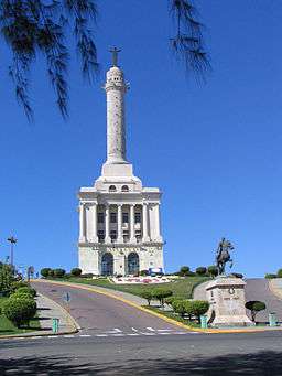 Monument to the Heroes of the Restoration War | |||
|
|||
| Country | |||
|---|---|---|---|
| Capital | Santiago de los Caballeros | ||
| - elevation | 175 m (574 ft) | ||
| - coordinates | 19°28′48″N 70°41′24″W / 19.48000°N 70.69000°WCoordinates: 19°28′48″N 70°41′24″W / 19.48000°N 70.69000°W | ||
| Area | 2,806.29 km2 (1,084 sq mi) | ||
| Population | 1,503,362 (2014) [1] | ||
| Density | 536/km2 (1,388/sq mi) | ||
| Province since | 1844 | ||
| Subdivisions | 10 municipalities 20 municipal districts | ||
| Congresspersons | 1 Senator 18 Deputies | ||
| Timezone | AST (UTC-4) | ||
| Area code | 1-809 1-829 1-849 | ||
| ISO 3166-2 | DO-25 | ||
| Postal Code | 51000 | ||
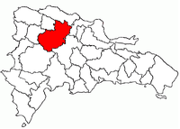 Location of Santiago Province | |||
| Website: www.provinciasantiago.gov.do/ | |||


Santiago (Spanish pronunciation: [sanˈtjaɣo]) is a province of the Dominican Republic, in the north of the country. Santiago is an intellectual, educational, and cultural center. It is also a major industrial center with rum, textile, cigarette and cigar industries based there. Shoe manufacturing, leather goods, and furniture making are important parts of the province's economic life. Santiago also has major Free Zone centers with four important industrial free zones; it also has an important cement factory. Santiago is home to one of the largest medical centers in the country, Clínica Unión Médica, which serves all 13 provinces of El Cibao.
Also within striking distance there are a good number of pleasant towns, many of which are quite prosperous. It is surrounded by tall mountains which have for years protected it from hurricanes and allows for dense tropical forests to develop on the slopes of such mountains, which are among the highest in the region.
Municipalities and municipal districts
The province as of June 20, 2006 is divided into the following municipalities (municipios) and municipal districts (distritos municipales – D.M.) within them:[2]
- Baitoa[3]
- Jánico
- El Caimito (D.M.)
- Juncalito (D.M.)
- Licey al Medio
- Las Palomas (D.M.)
- Puñal
- Canabacoa (D.M.)
- Guayabal (D.M.)
- Sabana Iglesia
- Sabana Iglesia Abajo (D.M.)
- Villa Bao (D.M.)
- Santiago de los Caballeros (Capital City)
- Alto Bao (D.M.)
- Hato del Yaque (D.M.)
- La Canela (D.M.)
- Pedro García (D.M.)
- San Francisco de Jacagua (D.M.)
- San José de las Matas
- El Rubio (D.M.)
- La Cuesta (D.M.)
- Las Placetas (D.M.)
- Las Manaclas (D.M.)
- Diferencia (D.M.)
- Tamboril
- Canca La Piedra (D.M.)
- Carlos Diaz (D.M)
- Amaceyes (D.M)
- Ceboruco (D.M)
- Villa Bisonó
- Navarrete (D.M.)
- Villa González
- El Limón (D.M.)
- Palmar Arriba (D.M.)
The following is a sortable table of the municipalities and municipal districts with population figures as of the 2014 estimate. Urban population are those living in the seats (cabeceras literally heads) of municipalities or of municipal districts. Rural population are those living in the districts (Secciones literally sections) and neighborhoods (Parajes literally places) outside of them. The population figures are from the 2014 population estimate.[4]
| Name | Total population | Urban population | Rural population |
|---|---|---|---|
| Baitoa | 32,570 | 8,958 | 23,612 |
| Jánico | 58,521 | 24,362 | 34,159 |
| Licey al Medio | 64,522 | 53,211 | 11,311 |
| Puñal | 77,562 | 74,188 | 3,374 |
| Sabana Iglesia | 47,522 | 15,842 | 31,680 |
| San José de las Matas | 68,212 | 35,900 | 32,312 |
| Santiago de los Caballeros | 1,000,087 | 733,109 | 266,978 |
| Tamboril | 79,522 | 14,700 | 64,822 |
| Villa Bisonó | 55,523 | 29,039 | 26,484 |
| Villa González | 59,321 | 29,927 | 29,394 |
| Santiago province | 1,543,362 | 1,019,236 | 524,126 |
For comparison with the municipalities and municipal districts of other provinces, see the list of municipalities and municipal districts of the Dominican Republic.

Notable natives
- José Acosta — Writer
- † Joaquín Balaguer — Dominican President
- † Rafael Filiberto Bonnelly — Dominican President
- † Pedro Francisco Bonó — Politician
- † Miguel Cocco Guerrero — Politician
- Francisco Dominguez Brito — Lawyer and politician
- † Rafael Estrella Ureña — Vicepresident of the Dominican Republic
- Román Franco Fondeur — Founder of Archivo Histórico Santiago (Santiago Historical Archive)
- † Antonio Guzmán Fernández — Dominican President
- † Pedro Manuel Hungría Founder of Archivo Histórico Santiago
- † Salvador Jorge Blanco — Dominican President
- Eduardo Leon Jimenes — Businessman, Founder of E Leon Jimenes
- Hipólito Mejía — Dominican President
- Orlando Jorge Mera — Politician, General Secretary of the Dominican Revolutionary Party
- † Yoryi Morel — Painter
- Johnny Pacheco — Music band leader
- † Donald Reid Cabral— Dominican President
- Miguel Diloné - Baseball player, MLB outfielder
- Luis Polonia - Baseball player, MLB left fielder
- Winston Llenas (a.k.a. Chilote) - Baseball player, MLB infielder/outfielder
- José Reyes — Baseball player, MLB shortstop
- Julián Tavárez — Baseball player, MLB pitcher
- † José Lima - Baseball player, MLB pitcher
- Joaquín Benoit - Baseball player, MLB pitcher
- Ramón Peña - Baseball player, MLB pitcher
- Carlos Gómez - Baseball player, MLB outfielder
- Tony Peña, Jr. - Baseball player, MLB pitcher
- Jhonny Peralta - Baseball player, MLB shortstop/third baseman
- Wandy Rodríguez - Baseball player, MLB pitcher
- † José Desiderio Valverde — Politician
- Amelia Vega — Miss Universe 2003
References
- ↑ Consejo Nacional de Población y Familia. "Estamaciones y Proyecciones de la Población Dominicana por Regiones, Provincias, Municipios y Distritos Municipales, 2014" (PDF) (in Spanish). Retrieved 2014-02-02.
- ↑ Oficina Nacional de Estadistica, Departamento de Cartografia, Division de Limites y Linderos. "Listado de Codigos de Provincias, Municipio y Distritos Municipales, Actualizada a Junio 20 del 2006" (in Spanish). Archived from the original on 2007-03-14. Retrieved 2007-01-24.
- ↑ new municipality of Baitoa
- ↑ Consejo Nacional de Población y Familia. "Estamaciones y Proyecciones de la Población Dominicana por Regiones, Provincias, Municipios y Distritos Municipales, 2014" (in Spanish). Archived from the original (PDF) on 2014-02-02. Retrieved 2014-02-02.
External links
- (in Spanish) Oficina Nacional de Estadística, Statistics Portal of the Dominican Republic
- (in Spanish) Oficina Nacional de Estadística, Maps with administrative division of the provinces of the Dominican Republic, downloadable in PDF format