San Juan Province (Dominican Republic)
| San Juan | |||
| Province | |||
|
|||
| Country | |||
|---|---|---|---|
| Capital | San Juan de la Maguana | ||
| - elevation | 415 m (1,362 ft) | ||
| - coordinates | 18°48′36″N 71°13′48″W / 18.81000°N 71.23000°WCoordinates: 18°48′36″N 71°13′48″W / 18.81000°N 71.23000°W | ||
| Area | 3,569.39 km2 (1,378 sq mi) | ||
| Population | 317,293 (2014) [1] | ||
| Density | 89/km2 (231/sq mi) | ||
| Province since | 1938 | ||
| Subdivisions | 6 municipalities 17 municipal districts | ||
| Congresspersons | 1 Senator 5 Deputies | ||
| Timezone | AST (UTC-4) | ||
| Area code | 1-809 1-829 1-849 | ||
| ISO 3166-2 | DO-22 | ||
| Postal Code | 72000 | ||
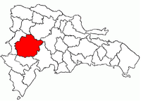 Location of the San Juan Province | |||

San Juan (Spanish pronunciation: [ˈsaŋ ˈxwan]) is a province of the Dominican Republic.[2] Before 1961 it was known as Benefactor. San Juan is the Republic's largest province, bearing a size of 3,569 square kilometers (1,378 miles), and it is landlocked.
Municipalities and municipal districts
The province as of June 20, 2006 is divided into the following municipalities (municipios) and municipal districts (distrito municipal - D.M.) within them:[3]
- Bohechío
- Arroyo Cano (D.M.)
- Yaque (D.M.)
- El Cercado
- Batista (D.M.)
- Derrumbadero (D.M.)
- Juan de Herrera
- Jinova (D.M.)
- La Rubia (D.M)
- San Juan de la Maguana
- El Rosario (D.M.)
- Guanito (D.M.)
- Hato del Padre (D.M.)
- La Jagua (D.M.)
- Las Maguanas (D.M.)
- Las Charcas de Maria Nova (D.M.)
- Pedro Corto (D.M.)
- Sabana Alta (D.M.)
- Sabaneta (D.M.)
- Las Matas de Farfán
- Carrera de Yegua (D.M.)
- Matayaya (D.M.)
- Vallejuelo
- Jorjillo (D.M.)
The following is a sortable table of the municipalities and municipal districts with population figures as of the 2012 census. Urban population are those living in the seats (cabeceras literally heads) of municipalities or of municipal districts. Rural population are those living in the districts (Secciones literally sections) and neighborhoods (Parajes literally places) outside of them.[4]
| Name | Total population | Urban population | Rural population |
|---|---|---|---|
| Bohechío | 9,652 | 4,208 | 5,444 |
| El Cercado | 25,688 | 2,585 | 23,103 |
| Juan de Herrera | 12,963 | 6,952 | 6,011 |
| Las Matas de Farfán | 70,586 | 35,054 | 35,532 |
| San Juan de la Maguana | 169,032 | 119,581 | 49,451 |
| Vallejuelo | 12,555 | 1,006 | 11,549 |
| San Juan province | 300,476 | 154,386 | 146,090 |
For comparison with the municipalities and municipal districts of other provinces see the list of municipalities and municipal districts of the Dominican Republic.
References
- ↑ Consejo Nacional de Población y Familia. "Estamaciones y Proyecciones de la Población Dominicana por Regiones, Provincias, Municipios y Distritos Municipales, 2014" (PDF) (in Spanish). Retrieved 2014-02-02.
- ↑ Gwillim Law - Statoids. "Provinces of the Dominican Republic". Retrieved 2007-05-26.
- ↑ Oficina Nacional de Estadistica, Departamento de Cartografia, Division de Limites y Linderos. "Listado de Codigos de Provincias, Municipio y Distritos Municipales, Actualizada a Junio 20 del 2006" (in Spanish). Archived from the original on 2007-03-14. Retrieved 2007-01-24.
- ↑ Consejo Nacional de Población y Familia. "Censos y Proyecciones de la Población Dominicana por Regiones, Provincias, Municipios y Distritos Municipales, 2012" (PDF) (in Spanish). Retrieved 2012-01-11.
External links
| Wikimedia Commons has media related to San Juan Province, Dominican Republic. |
- (in Spanish) Oficina Nacional de Estadística, Statistics Portal of the Dominican Republic
- (in Spanish) Oficina Nacional de Estadística, Maps with administrative division of the provinces of the Dominican Republic, downloadable in PDF format