Pedernales Province
| Pedernales | |||
| Province | |||
|
|||
| Country | |||
|---|---|---|---|
| Capital | Pedernales | ||
| - elevation | 10 m (33 ft) | ||
| - coordinates | 18°2′0″N 71°45′0″W / 18.03333°N 71.75000°WCoordinates: 18°2′0″N 71°45′0″W / 18.03333°N 71.75000°W | ||
| Area | 2,074.53 km2 (801 sq mi) | ||
| Population | 52,165 (2014) [1] | ||
| Density | 25/km2 (65/sq mi) | ||
| Province since | 1957 | ||
| Subdivisions | 2 municipalities 2 municipal districts | ||
| Congresspersons | 1 Senator 2 Deputies | ||
| Timezone | AST (UTC-4) | ||
| Area code | 1-809 1-829 1-849 | ||
| ISO 3166-2 | DO-16 | ||
| Postal Code | 84000 | ||
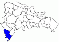 Location of the Pedernales Province | |||

Pedernales (from Spanish, meaning 'Flints'; pronounced [peðeɾˈnales]) is the southernmost province of the Dominican Republic, including the offshore island of Isla Beata. It was split from Barahona in 1957. Of its 2,074.53 km², 1374 km² belong to the Jaragua National Park.
According to the UNFPA, in 2012 thirty percent of the province’s population was of Haitian origin. As of 2015, it is estimated that Haitians are roughly 50% of the population.
Municipalities and municipal districts
The province as of June 20, 2006 is divided into the following municipalities (municipios) and municipal districts (distrito municipal - M.D.) within them:[2]
- Pedernales, head municipality of the province
- José Francisco Peña Gómez (M.D.)
- Oviedo
- Juancho (M.D.)
The following is a sortable table of the municipalities and municipal districts with population figures as of the 2012 census. Urban population are those living in the seats (cabeceras literally heads) of municipalities or of municipal districts. Rural population are those living in the districts (Secciones literally sections) and neighborhoods (Parajes literally places) outside of them.[3]
For comparison with the municipalities and municipal districts of other provinces see the list of municipalities and municipal districts of the Dominican Republic.
| Name | Total population | Urban population | Rural population |
|---|---|---|---|
| Oviedo | 10,986 | 3,699 | 7,287 |
| Pedernales | 27,955 | 16,967 | 10,988 |
| Pedernales province | 38,941 | 20,666 | 18,275 |
References
- ↑ Consejo Nacional de Población y Familia. "Estamaciones y Proyecciones de la Población Dominicana por Regiones, Provincias, Municipios y Distritos Municipales, 2014" (PDF) (in Spanish). Retrieved 2014-02-02.
- ↑ Oficina Nacional de Estadistica, Departamento de Cartografia, Division de Limites y Linderos. "Listado de Codigos de Provincias, Municipio y Distritos Municipales, Actualizada a Junio 20 del 2006" (in Spanish). Archived from the original on March 14, 2007. Retrieved 2007-01-24.
- ↑ Consejo Nacional de Población y Familia. "Censos y Proyecciones de la Población Dominicana por Regiones, Provincias, Municipios y Distritos Municipales, 2012" (PDF) (in Spanish). Retrieved 2012-01-11.
- (in Spanish) Oficina Nacional de Estadística, Statistics Portal of the Dominican Republic
- (in Spanish) Oficina Nacional de Estadística, Maps with administrative division of the provinces of the Dominican Republic, downloadable in PDF format