J Church
The J Church is a Muni Metro light rail line in San Francisco, California, mainly serving the Noe Valley and Balboa Park neighborhoods, connecting them to downtown.
Route description
The line runs from Embarcadero Station in the Financial District to Balboa Park Station and the Balboa Park neighborhood near City College of San Francisco. The downtown portion of the line uses the Market Street Subway, along with four other Muni Metro lines (K/T, L, M and N lines). The J exits the tunnel at Duboce Avenue along with the N Judah and turns onto Church Street. Between 18th and 20th Street, the line cuts through Dolores Park in a private right-of-way featuring a 9% grade, the steepest section of the Muni Metro.[3] After crossing 20th Street, it cuts across the blocks east of Church, around a steep hill and returns to Church Street at 22nd Street in Noe Valley. The J then follows Church to 30th Street, then to San Jose Avenue and Geneva. Between Randall and Cotter Streets, there is a right-of-way in the middle of San Jose Avenue. At the end of the line, the J loops around the Metro yard at San Jose and Geneva, alongside Balboa Park Station.
The J Church line stops at large stations for the downtown section of the route and at smaller stops on the rest of the line. Most of the smaller stops are designated by a sign on the sidewalk, while a few have concrete "islands" in the middle of the street next to the tracks that may provide access for wheelchairs.
While most other lines in the rail system can be run in two-car configurations, the J line is almost always run with a single car in order to accommodate the stops in the right-of-way, which are not long enough to have two light rail cars with open doors simultaneously.
Operation
The J Church begins service at 5 a.m. weekdays, 6 a.m. Saturdays and 8 a.m. Sundays and continues until 12:15 a.m. every night. Headways range from 7 to 15 minutes during the day, and 15 to 20 minutes at night. There is no late night service along the entire J line. Some of the route is covered by the L-Owl and N-Owl service provided by diesel buses run on Market Street between Church Street and Steuart Street. Owl service on the 24 Divisadero line runs near the portion of the J line north of 30th Street, and 14 Mission owl service runs near the portion of the line south of 30th.
History
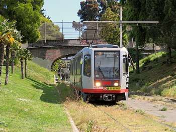
.jpg)
With track work largely completed by 1916,[4] service began as one of San Francisco's streetcar lines on August 11, 1917.[2] As part of the creation of the Muni Metro system, it was partially converted to modern light rail operation in 1981 - the last line to do so.[5][6] While many streetcar lines were converted to bus lines after World War II, the J Church avoided this due to the private right-of-way it uses to climb the steepest grades on Church Street, between 18th Street and 22nd Street.[7]
Extension to Balboa Park
The outer end of the line was originally at Church and 30th Streets, where streetcars used a wye to turn around. Studies to extend the line from its southern terminus had been made in the 1920s.[4] In 1991, the tracks were extended to the Balboa Park BART station and the Metro Center (Muni light-rail maintenance and operations base), giving J-line cars a much shorter connection to the yard than previously. However, the 2.3-mile (3.7 km) new section was initially used only by light rail cars starting or ending their runs;[8] all-day J-line service was not extended along the new tracks until March 1992.
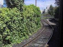
.jpg)
This trackage was laid along the Bernal Cut, the former right-of-way of the San Francisco & San Jose Railroad.[4]
This extension of the J-line to the Metro Center now also provides vintage F Market cars a connection to the adjacent Cameron Beach Yard, where they are stored when not in service. Occasionally J-Church streetcars use the siding at 30th and Church as a terminus during rush hours, or during irregular operations.
The 19th Avenue Platform & Trackway Improvement Project originally included pocket tracks to allow J Church trains to continue past Balboa Park with service to Stonestown. Due to community backlash, the compromise plan did not include the facilities necessary to run joint J-M service.[5]
The line was temporarily through-routed with the surface section of the K Ingleside line from June 25 to August 24, 2018 due to the Twin Peaks Tunnel shutdown.[9]
Future plans
In March 2014, Muni released details of the proposed implementation of their Transit Effectiveness Project (later rebranded MuniForward), which included a variety of changes for the J Church line intended to improve reliability and decrease travel times. The proposed changes included the removal of two stops (Liberty and Church and 30th Street), minor relocations of several other stops, construction of boarding islands and transit bulbs, and transit-only lanes on three blocks of Church Street, plus an increase in frequency from 9.5-minute headways to 8-minute headways during the morning peak.[10]
Most of the changes will be included in the proposed J Church Rapid Project. However, one element - dedicated transit/taxi lanes and left turn restrictions on Church Street between Duboce Avenue and 16th Street - was chosen for implementation as a pilot project to test its effectiveness. The red-painted dedicated center lanes (for use also by the 22-Fillmore bus) and turn restrictions were added in March 2013. The project proved to reduce travel time and improve reliability on both rail and bus, while not significantly increasing travel time in private automobiles.[11] Based on these positive results, the SFMTA Board made the changes permanent in June 2015.[12]
With the completion of the M Ocean View Subway, the J Church will be re-routed to connect with the M Ocean View at a new four-track subway station at SF State. The J line is expected to enter a new portal on 19th Avenue near Monticello Street with a subway tunnel following approximately the current M line alignment between Monticello Street and Holloway Avenue along 19th Avenue.[13][14]
Stations
| Neighborhood | Station | Transfers and connections | Notes |
|---|---|---|---|
| Financial District | Connects to F Market & Wharves and BART; within walking distance of E Embarcadero Serves Ferry Building | ||
| Connects to F Market & Wharves and BART | |||
| Connects to F Market & Wharves and BART | |||
| Civic Center | Connects to F Market & Wharves and BART | ||
| Connects to F Market & Wharves | |||
| Duboce Triangle | No outbound stop Meets N Judah via a separate platform | ||
| Church and 14th Street (outbound) Church and Market Street (inbound) |
*Connects with K, L, M, T and S at the Church Street Station in the Market Street Subway Connects with F Market & Wharves streetcar Muni bus lines: 22, 37 | ||
| Castro | Church and 16th Street | Muni bus line: 22 | |
| Muni bus: 33 | |||
| Mission District | Right Of Way/20th Street | Located on its own right-of-way in Dolores Park | |
| Right Of Way/Liberty | Right-of-way | ||
| Noe Valley | Right Of Way/21st Street | Right-of-way | |
| Church and 22nd Street | |||
| Muni bus: 48 | |||
| Church and Clipper | |||
| Church and 27th Street | |||
Church and Day Street (outbound) |
|||
| Church and 30th Street (inbound only) | Muni busses: 24, 36 | ||
| Bernal Heights | 30th Street and Dolores | Muni busses: 24, 36 | |
| Muni bus: 14, 49 | |||
| Glen Park | San Jose and Bosworth | Located across the street from the Glen Park BART station. Muni bus lines: 23, 35, 36, 44, 52 |
|
| Balboa Park | San Jose and Santa Rosa | ||
| San Jose and Santa Ynez | |||
| San Jose and Ocean | |||
| San Jose and Santa Rosa | Muni bus: 49 | ||
| Outbound terminus Connects with BART via Muni Metro's mezzanine level *Utilizes turn around shared with K Ingleside; within walking distance of M Ocean View Muni bus lines: 8, 8BX, 29, 43, 49, 54, 88 |
References
- ↑ "TEP Route Data & Proposed Changes". San Francisco Municipal Transportation Agency (SFMTA). 2013. Retrieved 2013-12-15.
- 1 2 "Happy Centennial, J-Church". streetcar.org. Market Street Railway. Retrieved 15 August 2017.
- ↑ "General Information". San Francisco Metropolitan Transportation Agency. Retrieved September 20, 2016.
- 1 2 3 Menzies, Jeremy. "Hooray for the J: 100 Years on the J Church". sfmta.com. San Francisco Municipal Transportation Agency. Retrieved 15 August 2017.
- 1 2 Callwell, Robert (September 1999). "Transit in San Francisco: A Selected Chronology, 1850-1995" (PDF). San Francisco Municipal Railway.
- ↑ McKane, John; Perles, Anthony (1982). Inside Muni: The Properties and Operations of the Municipal Railway of San Francisco. Glendale, CA (US): Interurban Press. pp. 189–190. ISBN 0-916374-49-1.
- ↑ Perles, Anthony (1981). The People's Railway: The History of the Municipal Railway of San Francisco. Interurban Press. pp. 176, 181. ISBN 0916374424.
- ↑ Modern Tramway. UK: Ian Allan Publishing: 430. December 1991. Missing or empty
|title=(help) - ↑ "Twin Peaks Tunnel Improvements". San Francisco Municipal Transportation Agency. June 25, 2018. Archived from the original on June 26, 2018.
- ↑ "Chapter 3: Proposals by Route". Transit Effectiveness Project Implementation Workbook (PDF). San Francisco Municipal Transportation Agency. March 24, 2014. pp. 52–56.
- ↑ "Church Street Transit Lanes: Final Report" (PDF). San Francisco Municipal Transportation Agency. February 2015.
- ↑ Chin, Jerrold (June 3, 2015). "Church Street transit-only lanes become permanent". SFBay.
- ↑ https://www.sfmta.com/sites/default/files/projects/2016/Station%203%20Street.pdf
- ↑ https://www.sfmta.com/sites/default/files/projects/2016/Full-size%20rail%20map.pdf
External links
| Wikimedia Commons has media related to J Church. |
Route map:
| Muni Metro | |||||||
|---|---|---|---|---|---|---|---|
| Muni Metro system features | |||||||
| Heritage streetcar services | |||||||
| Other Muni services | |||||||
| Projects |
| ||||||
| Connecting services | |||||||
| Miscellaneous |
| ||||||