Ishinomaki
| Ishinomaki 石巻市 | |||
|---|---|---|---|
| City | |||
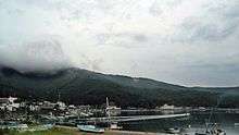
 Clockwise from top: View of Mount Kinka from Ojika Peninsula, Makiyama Iris Park, Tashirojima, Ojika Whale Park, Sasa-kamaboko, Ishinomaki Saint John the Apostle Orthodox Church, Mount Hiyori | |||
| |||
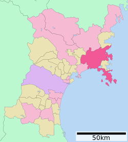 Location of Ishinomaki in Miyagi Prefecture | |||
 Ishinomaki | |||
| Coordinates: 38°25′3.3″N 141°18′9.8″E / 38.417583°N 141.302722°ECoordinates: 38°25′3.3″N 141°18′9.8″E / 38.417583°N 141.302722°E | |||
| Country | Japan | ||
| Region | Tōhoku | ||
| Prefecture | Miyagi | ||
| Government | |||
| • Mayor | Hiroshi Kameyama | ||
| Area | |||
| • Total | 554.58 km2 (214.12 sq mi) | ||
| Population (May 31, 2017) | |||
| • Total | 146,993 | ||
| • Density | 269/km2 (700/sq mi) | ||
| Time zone | UTC+9 (Japan Standard Time) | ||
| - Tree | Japanese Black Pine | ||
| - Flower | Azalea | ||
| Phone number | 0225-95-1111 | ||
| Address | 14-1 Kokucho, Ishinomaki-shi, Miyagi-ken 986-8501 | ||
| Website | http://www.city.ishinomaki.lg.jp/ | ||

Ishinomaki (石巻市 Ishinomaki-shi) is a city located in Miyagi Prefecture, Japan. As of 28 February 2017, the city has an estimated population of 146,993, and a population density of 269 persons per km2 in 61,233 households.[1] The total area of the city is 554.58 square kilometres (214.12 sq mi).
Geography
Ishinomaki is in northeastern Miyagi Prefecture. The city borders on Matsushima Bay to the south and Kesennuma Bay to the north, with the Kitakami Mountains to the west. Its coastline forms part of the Sanriku Fukkō National Park, which stretches north to Aomori Prefecture. Ishinomaki includes Tashirojima (also known as "Cat Island"), Ajishima, and Kinkasan, three islands off the south coast of Oshika Peninsula.
Neighboring municipalities
- Miyagi Prefecture
Climate
Ishinomaki has a humid climate (Köppen climate classification Cfa) characterized by mild summers and cold winters. The average annual temperature in Ishinomaki is 11.7 °C. The average annual rainfall is 1174 mm with September as the wettest month. The temperatures are highest on average in August, at around 24.2 °C, and lowest in January, at around 0.6 °C.[2]
| Climate data for Ishinomaki, Miyagi | |||||||||||||
|---|---|---|---|---|---|---|---|---|---|---|---|---|---|
| Month | Jan | Feb | Mar | Apr | May | Jun | Jul | Aug | Sep | Oct | Nov | Dec | Year |
| Average high °C (°F) | 4.1 (39.4) |
4.4 (39.9) |
7.8 (46) |
13.6 (56.5) |
18.3 (64.9) |
21.3 (70.3) |
24.7 (76.5) |
27.1 (80.8) |
23.4 (74.1) |
18.2 (64.8) |
12.6 (54.7) |
7.2 (45) |
15.2 (59.4) |
| Daily mean °C (°F) | 0.3 (32.5) |
0.5 (32.9) |
3.5 (38.3) |
9.1 (48.4) |
14.0 (57.2) |
17.7 (63.9) |
21.3 (70.3) |
23.6 (74.5) |
19.7 (67.5) |
13.8 (56.8) |
8.1 (46.6) |
3.1 (37.6) |
11.2 (52.2) |
| Average low °C (°F) | −3.2 (26.2) |
−3.0 (26.6) |
−0.4 (31.3) |
4.9 (40.8) |
10.2 (50.4) |
14.7 (58.5) |
18.7 (65.7) |
20.9 (69.6) |
16.4 (61.5) |
9.5 (49.1) |
3.8 (38.8) |
−0.5 (31.1) |
7.7 (45.8) |
| Average precipitation mm (inches) | 39.3 (1.547) |
47.7 (1.878) |
66.6 (2.622) |
91.5 (3.602) |
98.7 (3.886) |
108.5 (4.272) |
125.6 (4.945) |
123.7 (4.87) |
140.9 (5.547) |
108.3 (4.264) |
64.1 (2.524) |
32.7 (1.287) |
1,047.6 (41.244) |
| Average snowfall cm (inches) | 14 (5.5) |
28 (11) |
11 (4.3) |
0 (0) |
0 (0) |
0 (0) |
0 (0) |
0 (0) |
0 (0) |
0 (0) |
1 (0.4) |
7 (2.8) |
61 (24) |
| Average relative humidity (%) | 72 | 72 | 69 | 71 | 74 | 82 | 85 | 83 | 81 | 77 | 74 | 73 | 76 |
| Mean monthly sunshine hours | 166.1 | 160.9 | 193.4 | 192.8 | 211.9 | 153.6 | 147.0 | 178.2 | 136.1 | 157.7 | 146.9 | 150.5 | 1,995.1 |
| Source: NOAA (1961-1990) [3] | |||||||||||||
Demographics
Per Japanese census data,[4] the population of Ichinomaki has declined over the past 40 years.
| Census Year | Population |
|---|---|
| 1970 | 177, 597 |
| 1980 | 186,094 |
| 1990 | 182,911 |
| 2000 | 174,778 |
| 2010 | 160,826 |
History
The area of present-day Ishinomaki was part of ancient Mutsu Province. During the Sengoku period, the area was contested by various samurai clans before the area came under the control of the Date clan of Sendai Domain during the Edo period. The town prospered as a major port and transshipment center for coastal shipping between Edo and northern Japan. The town of Ishinomaki was established within Oshika District on June 1, 1889 with the establishment of the modern municipalities system.
The modern city was founded on April 1, 1933. On April 1, 2005, Ishinomaki absorbed the neighboring towns of Kahoku, Kanan, Kitakami, Monou and Ogatsu, and the town of Oshika to more than quadruple its area and add nearly 60,000 people to its population.
The town of Ogatsu is regionally famous for its inkstones and has an annual scallop festival in the summer. Ayukawa, a town in Oshika, was formerly a base for several ships in Japan's whaling fleet.
2011 earthquake, tsunami, and subsidence
Ishinomaki was among the municipalities most seriously affected by the 2011 Tōhoku earthquake and tsunami.[5][6] Several tsunamis, up to about 10 metres (33 ft) high, traveled inland up to 5 kilometres (3.1 mi) from the coast. The tsunami destroyed around 80% of the 700 houses in the coastal port of Ayukawa, and the Kadonowaki neighborhood was largely leveled.[7][8] Approximately 46% of the city was inundated by the tsunami.[9] Following the tsunami, a Kamen Rider statue was found completely intact despite damage to the surrounding area; a writer for Tokyo Sports hoped that it would symbolically give hope to the survivors of the disaster.[10]
Many public schools were completely destroyed, including Ishinomaki Okawa Elementary School (大川小学校), which lost 70 of 108 students and nine of 13 teachers and staff[11] There is still anger among some of the parents of the dead students because the teachers had wasted precious time in debating whether to evacuate to higher ground. And when the decision was finally made, the teachers had decided to get to higher ground further away from the school which necessitated crossing a nearby river bridge. It was here while crossing the bridge that both the teachers and students were swept away by the tsunami. This decision is deemed unreasonable by many of the parents because there is a hill right behind the school, which they could have reached quickly. One of the teachers had tried to persuade the other teachers to bring the students to safety uphill soon after the earthquake; when he was unsuccessful, he evacuated himself, managing to persuade one of the students to go with him - both survived. One of the teachers who survived the tsunami at the bridge later committed suicide.[12][13][14][15][16]
As of 17 June 2011, a total of 3,097 deaths had been confirmed in Ishinomaki due to the tsunami, with 2,770 unaccounted for.[17] Approximately 29,000 city residents lost their homes.[18]
Ishinomaki employs several foreigners to teach English in all of its elementary and junior high schools, as well as the two municipal high schools. American teacher Taylor Anderson was killed by the tsunami. Since her death, her family has been active in supporting the Ishinomaki school district, and has set up programs to further English education.[19]
The earthquake shifted the city southeast and downward, lowering it by as much as 1.2 metres (3.9 ft) in some areas and causing it to flood twice daily at high tide. A once sandy beach in the Kadonowaki area completely disappeared and tides now reach the wall that once separated the beach from the road. Near the Mangakan Island, a walkway with benches was partially submerged in the river.[20]
Government
Ishinomaki has a mayor-council form of government with a directly elected mayor and a unicameral city legislature of 30 members.
Economy
Ishinomaki traditionally has been a center for commercial fishing, especially for the cultivation of oysters.
Education
- Ishinomaki Senshu University
- Ishinomaki has 36 public elementary schools, 20 public junior high schools and one public high school operated by the city government, and seven public high schools operated by the Miyagi Prefectural Board of Education. The prefectural also operates one special education school.
Transportation
Railway
Intercity bus
Daily scheduled intercity buses bound for the following cities, through the Sanriku Expressway, are being served from Ishinomaki Station.
- Sendai via Aeon Ishinomaki Shopping Center (Mall), by Miyakou Bus Co. Ltd., a subsidiary of Miyagi Transportation (Miyagi Kotsu) Co., Ltd.
- Shinjuku, Tokyo via Shibuya (overnight): via Sendai, operated by Miyagi Transportation (Miyagi Kotsu) Co., Ltd. and Keio Dentetsu Bus Corporation

Highways
- Sanriku Expressway (Ishinomaki-kanan, Kahoku, Monou-toyosato and Monou-tsuyama interchanges)
- National Route 45
- National Route 108
- National Route 398
Seaport
- Port of Ishinomaki
Local attractions
- San Juan Bautista, replica of a ship commissioned in 1613 by Date Masamune to transport an embassy to the Pope in Rome.
- Ishinomori Manga Museum along with Manga Road celebrating Shotaro Ishinomori's manga legacy.
- Ishinomaki Saint John the Apostle Orthodox Church
- Ishii lock
- Numazu Shell Midden, a Jōmon period National Historic Site
- Saitō Garden
- The reed fields at the mouth of the Kitakami River at Ishinomaki is listed as one of the 100 Soundscapes of Japan by the Ministry of the Environment [21]
Sister cities and friendship links
International
Japanese sister cities

Noted people from Ishinomaki
- Jun Azumi, politician
- Kasugafuji Akihiro, sumo wrestler
- Tatsuji Fuse. lawyer, social activist
- Sukekiyo Kameyama, voice actor
- Isamu Kosugi, actor, movie director
- Naoya Shiga, author
- Mayo Suzukaze, actress
- Keiko Suzuka, actress
References
- ↑ Ishinomaki city official home page
- ↑ Ishinomaki climate data
- ↑ "Ishinomaki Climate Normals 1961-1990". National Oceanic and Atmospheric Administration. Retrieved December 30, 2012.
- ↑ Ichinomaki population statistics
- ↑ Satellite Photos of Japan Before and After the Quake and Tsunami New York Times, 13 March 2011
- ↑ Kyodo News, "Death toll may surpass 10,000 in Miyagi", The Japan Times, 14 March 2011, p. 1.
- ↑ Kyodo News, "Miyagi coastal whaling port pulverized, little more than memory", The Japan Times, 18 March 2011, p. 3.
- ↑ Gihooly, Rob, "'Nothing can prepare you to witness this', The Japan Times, 20 March 2011, p. 7.
- ↑ NHK, "Tsunami flooded 100 square kilometers of city land", 29 March 2011.
- ↑ "仮面ライダー無事だった". Tokyo Sports. 2011-03-18. Archived from the original on 2011-03-21. Retrieved 2014-04-22.
- ↑ Lah, Kyung. "In Japan, parents try to go on: 'My child should come home to me'." CNN. March 23, 2011. Retrieved on March 23, 2011.
- ↑ Gilhooly, Rob, "Time has stopped for parents of dead and missing children", The Japan Times, 11 March 2012, p. 3.
- ↑ Gilhooly, Rob (13 October 2011). "Parents unable to let go continue search for missing kids". The Japan Times. Japan: The Japan Times Ltd. p. 3. Archived from the original on 14 December 2011. Retrieved 13 March 2013.
- ↑ "Loss-staggered school reopens". The Japan Times. Japan: The Japan Times Ltd. 19 April 2011. p. 3. Archived from the original on 14 May 2011. Retrieved 13 March 2013.
- ↑ Kyodo News, "Loss-hit Ishinomaki school opens", The Japan Times, 22 April 2011, p. 2.
- ↑ Kyodo News, "School that lost 70% of its pupils mourns", The Japan Times, 29 April 2011, p. 1.
- ↑ Kyodo News, "Ishinomaki can't tally March 11 missing", The Japan Times, 17 June 2011, p. 2.
- ↑ Robson, Seth, "Ishinomaki residents rebuild their lives as they rebuild their town", Stars and Stripes, 30 August 2011.
- ↑ . Retrieved on June 22, 2013.
- ↑ Alabaster, Jay (May 9, 2011). "Quake shifted Japan; towns now flood at high tide". Contra Costa Times/Associated Press. Retrieved May 9, 2011.
- ↑ "100 Soundscapes of Japan". Ministry of the Environment. Retrieved 8 December 2015.
- 1 2 "International Exchange". List of Affiliation Partners within Prefectures. Council of Local Authorities for International Relations (CLAIR). Archived from the original on 22 December 2015. Retrieved 21 November 2015.
External links
| Wikimedia Commons has media related to Ishinomaki. |
- Official Website (in Japanese)
| Wards of Sendai | |
|---|---|
| Cities | |
| Districts | |
| Authority control |
|---|