Isaszeg
| Isaszeg | |||
|---|---|---|---|
 | |||
| |||
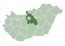
 Isaszeg Location of Isaszeg in Hungary | |||
| Coordinates: 47°31′48″N 19°23′57″E / 47.53005°N 19.39913°E | |||
| Country | Hungary | ||
| Region | Central Hungary | ||
| County | Pest | ||
| Subregion | Gödöllői | ||
| Rank | City | ||
| Area[1] | |||
| • Total | 54.83 km2 (21.17 sq mi) | ||
| Population (2017)[2] | |||
| • Total | 11,402[3] | ||
| Time zone | UTC+1 (CET) | ||
| • Summer (DST) | UTC+2 (CEST) | ||
| Postal code | 2117 | ||
| Area code | +36 28 | ||
| KSH code | 07807[4] | ||
| Website | www.isaszeg.hu | ||


Isaszeg is a town in Pest county, Budapest metropolitan area, Hungary. It has a population of 10,979 (2007).
Sightseeing
On the top of the cemetery hill stands the old parochial church of the village. It was last rebuilt in gothic style. However, the foundations of the old rotunda is visible north and south of the nave of the church. The recent church was built by the eastern extension (apsis) and by western extension (nave and choir) of the original rotunda. The church has western tower with rectangular lower part and octagonal upper part, as in many Hungarian old churches (for example: Nagymaros, Csurgó, Aracs, Somogyvámos, Szeged - Dömötör tower, Felsőörs)
Twin towns — sister cities
Isaszeg is twinned with:
Notable residents
- György Lázár (1924 - 2014), former Communist politician.
References
- ↑ Isaszeg at the Hungarian Central Statistical Office (Hungarian).
- ↑ Isaszeg at the Hungarian Central Statistical Office (Hungarian). 2017
- ↑ Isaszeg, KSH
- ↑ Isaszeg at the Hungarian Central Statistical Office (Hungarian).
- Genthon I. (1959): Magyarország műemlékei. (Architectural Heritage of Hungary). Budapest
- Gerevich Tibor: Magyarország románkori emlékei. (Die romanische Denkmäler Ungarns.) Egyetemi nyomda. Budapest, 1938.
- Gerő, L. (1984): Magyar műemléki ABC. (Hungarian Architectural Heritage ABC.) Budapest
- Gervers-Molnár, V. (1972): A középkori Magyarország rotundái. (Rotunda in the Medieval Hungary). Akadémiai, Budapest
- Szőnyi O. (É.n.): Régi magyar templomok. Alte Ungarische Kirchen. Anciennes églises Hongroises. Hungarian Churches of Yore. A Műemlékek Országos Bizottsága. Mirályi Magyar Egyetemi Nyomda, Budapest.
- Henszlmann, I. (1876): Magyarország ó-keresztyén, román és átmeneti stylü mű-emlékeinek rövid ismertetése, (Old-Christian, Romanesque and Transitional Style Architecture in Hungary). Királyi Magyar Egyetemi Nyomda, Budapest
External links
| Wikimedia Commons has media related to Isaszeg. |
- Official website in Hungarian
- Isaszeg Map
- Aerial photography of Isaszeg
| Towns (6) | ||
|---|---|---|
| Large villages (4) | ||
| Villages (5) | ||

Coordinates: 47°32′N 19°24′E / 47.533°N 19.400°E
This article is issued from
Wikipedia.
The text is licensed under Creative Commons - Attribution - Sharealike.
Additional terms may apply for the media files.