Törtel
| Törtel | ||
|---|---|---|
 | ||
| ||
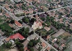
 Törtel Location of Törtel in Hungary | ||
| Coordinates: 47°7′17.33″N 19°56′23.03″E / 47.1214806°N 19.9397306°E | ||
| Country | Hungary | |
| Region | Central Hungary | |
| County | Pest | |
| Subregion | Ceglédi | |
| Rank | Village | |
| Area[1] | ||
| • Total | 84.16 km2 (32.49 sq mi) | |
| Population (1 January 2008)[2] | ||
| • Total | 4,436 | |
| • Density | 53/km2 (140/sq mi) | |
| Time zone | UTC+1 (CET) | |
| • Summer (DST) | UTC+2 (CEST) | |
| Postal code | 2747 | |
| Area code | +36 53 | |
| KSH code | 22008[3] | |
| Website | www.tortel.hu | |
References
- ↑ Törtel at the Hungarian Central Statistical Office (Hungarian).
- ↑ Törtel at the Hungarian Central Statistical Office (Hungarian). 1 January 2008
- ↑ Törtel at the Hungarian Central Statistical Office (Hungarian).
This article is issued from
Wikipedia.
The text is licensed under Creative Commons - Attribution - Sharealike.
Additional terms may apply for the media files.