Csömör
| Csömör | ||
|---|---|---|
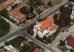 Aerial photograph of Csömör showing the Roman-Catholic church | ||
| ||
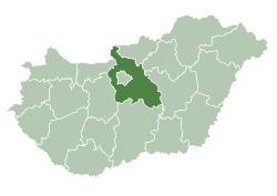
 Csömör Location of Csömör in Hungary | ||
| Coordinates: 47°32′49″N 19°13′28″E / 47.54685°N 19.22451°E | ||
| Country | Hungary | |
| Region | Central Hungary | |
| County | Pest | |
| Subregion | Gödöllői | |
| Rank | Town | |
| Government | ||
| • Mayor | Fábri István | |
| Area[1] | ||
| • Total | 22.67 km2 (8.75 sq mi) | |
| Population (1 January 2008)[2] | ||
| • Total | 8,723 | |
| • Density | 380/km2 (1,000/sq mi) | |
| Time zone | UTC+1 (CET) | |
| • Summer (DST) | UTC+2 (CEST) | |
| Postal code | 2141 | |
| Area code | +36 28 | |
| KSH code | 22804[3] | |
| Website | www.csomor.hu | |
Csömör (Hungarian: [ˈt͡ʃømør]) is a village in Hungary, in Pest county, Budapest metropolitan area in the Gödöllő subregion (kistérség). It is west of Kistarcsa, north of the 16th district of Budapest, on the western part of the Gödöllő hills, in the turning of the Csömör stream. It has a population of 8,433 (2007).
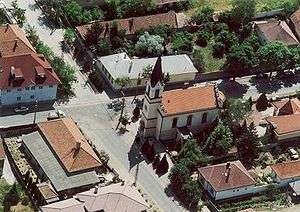
.jpg)
History
Ceramic pieces were found from the new stone age (3200–3000 BC) in the area of the Urasági-tag, the Bab-földek (bean fields) and the Rét-pótlék.
Ceramic pieces were found from the bronze age (1900–1800 BC) on the area of the Urasági-tag [ˈurɒʃaːɡitɒɡ] and the Szeder-völgyi-dűlő [ˈsedervølɟi ˈdyːløː]. On the 64 Erzsébet Street [ˈɛrʒeːbet] were found troves from the vatyai culture [ˈvɒcɒʲi] (1700–1400 BC).
A Celtic cemetery was dug out behind the strand, which is from the iron age (380–300 BC). Between the troves there are bracelets, fibulas, chiffons, a scabbard with sword, and chain.
During the third and the fourth century there was a Sarmatian village on the area of Csömör, both sides of the stream. During the explorations a Roman bowl (from the third century) and pottery were found.
Pieces of bowl were found on the area of the Réti-dűlős [ˈreːti ˈdyːløː] (singular: Réti-dűlő) and Rétpótlék [ˈreːtpoːtleːk] from the Avar age.
Ceramic pieces were found on the area of the Káposztáss [ˈkaːpostaːʃ] (singular: Káposztás) and Réti-dűlős, that were made during the tenth and the eleventh century.
Memorial of communism's victims
In 2006 the Gloria Victis Memorial was created in honor of the casualties of universal communism: it is situated adjacent to the cemetery of the town.
References
- ↑ Csömör at the Hungarian Central Statistical Office (Hungarian).
- ↑ Csömör at the Hungarian Central Statistical Office (Hungarian). 1 January 2008
- ↑ Csömör at the Hungarian Central Statistical Office (Hungarian).
External links
![]()
- Official website in Hungarian
| Towns (6) | ||
|---|---|---|
| Large villages (4) | ||
| Villages (5) | ||