Dömsöd
| Dömsöd | ||
|---|---|---|
| ||
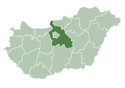
 Dömsöd Location of Dömsöd in Hungary | ||
| Coordinates: 47°05′40″N 19°00′32″E / 47.09442°N 19.00892°E | ||
| Country | Hungary | |
| Region | Central Hungary | |
| County | Pest | |
| Subregion | Ráckevei | |
| Rank | Town | |
| Area[1] | ||
| • Total | 72.42 km2 (27.96 sq mi) | |
| Population (1 January 2008)[2] | ||
| • Total | 5,784 | |
| • Density | 80/km2 (210/sq mi) | |
| Time zone | UTC+1 (CET) | |
| • Summer (DST) | UTC+2 (CEST) | |
| Postal code | 2344 | |
| Area code | +36 24 | |
| KSH code | 29647[3] | |
| Website | www.domsod.hu | |

References
- ↑ Dömsöd at the Hungarian Central Statistical Office (Hungarian).
- ↑ Dömsöd at the Hungarian Central Statistical Office (Hungarian). 1 January 2008
- ↑ Dömsöd at the Hungarian Central Statistical Office (Hungarian).
External links
![]()
- Official website in Hungarian
| Town (1) |
| |
|---|---|---|
| Large villages (2) | ||
| Villages (8) | ||

This article is issued from
Wikipedia.
The text is licensed under Creative Commons - Attribution - Sharealike.
Additional terms may apply for the media files.