Gödöllő District
| Gödöllő District Gödöllői járás | ||
|---|---|---|
| Districts of Hungary | ||
| ||
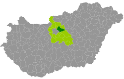 Gödöllő District within Hungary and Pest County. | ||
| Country |
| |
| County | Pest | |
| District seat | Gödöllő | |
| Area | ||
| • Total | 449.66 km2 (173.61 sq mi) | |
| Area rank | 4th in Pest | |
| Population (2011 census) | ||
| • Total | 139,826 | |
| • Rank | 1st in Pest | |
| • Density | 311/km2 (810/sq mi) | |

Gödöllő (Hungarian: Gödöllői járás) is a district in central-northern part of Pest County. Gödöllő is also the name of the town where the district seat is found. The district is located in the Central Hungary Statistical Region.
Geography
Gödöllő District borders with Aszód District to the northeast, Nagykáta District to the southeast, Vecsés District to the south, Budapest to the southwest, Dunakeszi District to the west, Vác District to the northwest. The number of the inhabited places in Gödöllő District is 15.
Municipalities
The district has 6 towns, 4 large villages and 5 villages. (ordered by population, as of 1 January 2013)[1]
- Csömör (9,077)
- Dány (4,424)
- Erdőkertes (7,505)
- Gödöllő (32,792) – district seat
- Isaszeg (11,210)
- Kerepes (9,943)
- Kistarcsa (12,046)
- Mogyoród (6,375)
- Nagytarcsa (3,883)
- Pécel (15,123)
- Szada (4,675)
- Vácszentlászló (2,040)
- Valkó (2,427)
- Veresegyház (16,333)
- Zsámbok (2,352)
The bolded municipalities are cities, italics municipalities are large villages.
Demographics
Religion in Gödöllő District (2011 census)
In 2011, it had a population of 139,826 and the population density was 311/km².
| Year | County population[2] | Change |
|---|---|---|
| 2011 | 139,826 | n/a |
Ethnicity
Besides the Hungarian majority, the main minorities are the Roma (approx. 2,800), German (1,600), Slovak (1,000), Romanian (650), Russian (300), Polish (150), Ukrainian and Bulgarian (100).
Total population (2011 census): 139,826
Ethnic groups (2011 census):[3] Identified themselves: 129,792 persons:
- Hungarians: 120,988 (93.22%)
- Gypsies: 2,774 (2.14%)
- Germans: 1,641 (1.26%)
- Others and indefinable: 4,389 (3.38%)
Approx. 10,000 persons in Gödöllő District did not declare their ethnic group at the 2011 census.
Religion
Religious adherence in the county according to 2011 census:[4]
- Catholic – 51,043 (Roman Catholic – 49,899; Greek Catholic – 1,128);
- Reformed – 14,691;
- Evangelical – 3,871;
- other religions – 4,244;
- Non-religious – 22,780;
- Atheism – 2,584;
- Undeclared – 40,613.
Gallery
_6.jpg)
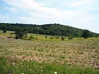 Landscape near Veresegyház
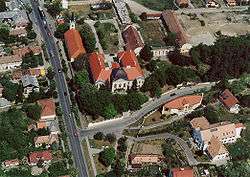 Ráday Mansion in Pécel
 Aerial view of Dány
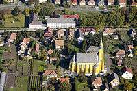
.jpg) Grassalkovich-Pejacsevich Mansion in Szada
Grassalkovich-Pejacsevich Mansion in Szada
See also
References
- ↑ A KSH 2013. évi helységnévkönyve
- ↑ népesség.com, "Gödöllői járás népessége"
- ↑ 4.1.6.1 A népesség nemzetiség szerint, 2011, (in Hungarian)
- ↑ 4.1.7.1 A népesség vallás, felekezet szerint, 2011, (in Hungarian)
External links
| Towns (6) | ||
|---|---|---|
| Large villages (4) | ||
| Villages (5) | ||
Coordinates: 47°36′00″N 19°22′00″E / 47.6000°N 19.3667°E