California State Route 237
| ||||
|---|---|---|---|---|
| Southbay Freeway | ||||
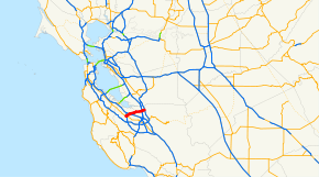 SR 237 highlighted in red | ||||
| Route information | ||||
| Defined by Streets and Highways Code § 537 | ||||
| Maintained by Caltrans | ||||
| Length | 11.00 mi[1] (17.70 km) | |||
| Existed |
1934-June 30, 1964 (as SR 9) 1964 Renumbering – present | |||
| Major junctions | ||||
| West end |
| |||
|
| ||||
| East end |
| |||
| Location | ||||
| Counties | Santa Clara | |||
| Highway system | ||||
| ||||

State Route 237 (SR 237) runs from El Camino Real (SR 82) in Mountain View to Interstate 680 in Milpitas. It runs south of the San Francisco Bay, connecting the East Bay to the Peninsula.
Route description
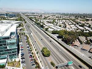
Route 237 begins at a junction of Grant Road with El Camino Real (SR 82) in Mountain View, as a four lane divided highway. Most traffic comes from California State Route 85. Westbound traffic can connect to Route 85 southbound, but the eastbound traffic connection to Route 85 northbound is labeled as an exit for U.S. 101. Route 237 intersects with Highway 101 at the southern corner of Moffett Field. After this intersection, a carpool lane is added, for a total of three lanes in either direction. It remains like this until the east end of the freeway at Interstate 880, where most eastbound traffic is directed to northbound I-880. The route then becomes a city street (an arterial road), Calaveras Boulevard, in Milpitas, terminating at Interstate 680.
Exit signs from U.S. 101 north to Route 237 west currently say "Mountain View-Alviso Road". Starting from half a mile after the highway's western terminus, and ending at the I-880 intersection, Route 237 is mostly constructed to Interstate standards, and is named the Southbay Freeway. It is not part of the Interstate system, however.
Route 237 is known for a number of companies that define Silicon Valley's technological landscape. Many major software and hardware manufacturers have their headquarters along 237. Some of these manufacturers include Lockheed-Martin, Brocade Communications Systems, Nortel Networks, Cisco Systems, Yahoo!, Juniper Networks, TiVo, Ariba and NetApp.
SR 237 is part of the California Freeway and Expressway System,[2] and is part of the National Highway System,[3] a network of highways that are considered essential to the country's economy, defense, and mobility by the Federal Highway Administration.[4]
Highway 237 Bikeway
The Highway 237 Bikeway is a 5-mile (8.0 km) pedestrian and bicycle path that parallels State Route 237. The majority of the path is separated from vehicular traffic, however, two sections comprising a total of 1.5 miles (2.4 km) follow an on-street alignment adjacent the freeway.
This bikeway serves as an important connector in the network of trails in San Jose and Santa Clara County. It intersects with the Guadalupe River Trail, which provides access to Downtown San Jose, as well as the San Tomas Aquino Creek and Coyote Creek trails.[5]
Express lanes
The SR 237 Express Lanes, the 4-mile-long (6.4 km) high-occupancy toll (HOT) lanes along Route 237 in both directions between North First Street in San Jose and I-880 in Milpitas, opened on March 20, 2012.[6] Instead of terminating exactly at the I-880 interchange, the Express Lanes continue along an connector ramp to I-880, so that eastbound Express Lane users merge directly into the I-880 northbound HOV lane, and I-880 southbound HOV lane users can directly enter Route 237's westbound Express Lane. Solo drivers are required to pay a toll via a FasTrak transponder. Later on, VTA will add express lanes to SR 85, US 101, and also extend the SR 237 Express Lanes to Mathilda Ave.
History
Before Route 237 was upgraded to freeway status in the mid-1990s, it was a four-lane expressway with at-grade intersections, known as Alviso-Milpitas Road or Milpitas-Alviso Road depending on different maps showing the description.
The Route 237 corridor has long been sought as a location for a freeway connector between Interstates 680 and 880. Many possible sites have been suggested, from Montague Expressway in North San Jose to Mission Boulevard in Fremont. One map printed before Route 237's construction to freeway standards between Alviso and 880 showed a new freeway across bay wetlands between Alviso and the Scott Creek Road interchange in South Fremont. Grading and underpasses for a freeway interchange are presently visible along 680 near Scott Creek Road.
Major intersections
Except where prefixed with a letter, postmiles were measured on the road as it was in 1964, based on the alignment that existed at the time, and do not necessarily reflect current mileage. R reflects a realignment in the route since then, M indicates a second realignment, L refers an overlap due to a correction or change, and T indicates postmiles classified as temporary (for a full list of prefixes, see the list of postmile definitions).[7] Segments that remain unconstructed or have been relinquished to local control may be omitted. The entire route is in Santa Clara County.
| Location | Postmile [7][1][8] | Exit [9] | Destinations | Notes | |
|---|---|---|---|---|---|
| Mountain View | R0.00 | Grant Road | Continuation beyond SR 82 | ||
| R0.00 | 1A | West end of SR 237 | |||
| | West end of freeway | ||||
| R0.38 | 1A | Eastbound exit and westbound entrance; SR 85 south exit 22A | |||
| R0.38 | 1B | Westbound exit and eastbound entrance; SR 85 north exit 22C | |||
| R0.61 | 1B | Dana Street | Signed as exit 1C westbound | ||
| M1.55 | 2 | Middlefield Road, Maude Avenue | |||
| Sunnyvale | 2.48 | 3A | Westbound exit is via exit 3B; US 101 north exit 396C, south via exit 396A | ||
| 2.48 | 3A | Eastbound exit is via exit 3B; US 101 south exit 396B, north via exit 396A | |||
| 2.99 | 3B | Mathilda Avenue – Sunnyvale | Former SR 9 south | ||
| R3.97 | 4 | Fair Oaks Avenue | Eastbound exit and westbound entrance | ||
| R4.60 | 5 | Lawrence Expressway (CR G2), Caribbean Drive | |||
| Santa Clara | R5.83 | 6 | Great America Parkway | ||
| San Jose | | — | SR 237 Express Lanes west | End of westbound Express Lanes | |
| 6.87 | 7 | North First Street | |||
| 8.02 | 8 | Zanker Road | |||
| | — | Start of eastbound Express Lanes; last access point from main eastbound SR 237 lanes | |||
| Milpitas | R9.13 | 9A | McCarthy Boulevard | ||
| 9.34 | 9 | Signed as exits 9B (south) and 9C (north); I-880 north exit 8B, south exit 8B-C | |||
| | East end of freeway | ||||
| 10.00 | 10 | Main Street | Interchange; westbound exit and eastbound entrance; former SR 238 | ||
| 11.08 | 11 | Interchange; signed as exits 11A (south) and 11B (north); east end of SR 237; I-680 exit 8 | |||
| 11.08 | Calaveras Boulevard | Continuation beyond I-680 | |||
| 1.000 mi = 1.609 km; 1.000 km = 0.621 mi | |||||
See also

References
- 1 2 California Department of Transportation (July 2007). "Log of Bridges on State Highways". Sacramento: California Department of Transportation.
- ↑ California State Legislature. "Section 250–257". Streets and Highways Code. Sacramento: California State Legislature. Retrieved June 9, 2017.
- ↑ Federal Highway Administration (March 25, 2015). National Highway System: San Francisco, CA (PDF) (Map). Scale not given. Washington, DC: Federal Highway Administration. Retrieved September 5, 2017.
- ↑ Natzke, Stefan; Neathery, Mike & Adderly, Kevin (June 20, 2012). "What is the National Highway System?". National Highway System. Washington, DC: Federal Highway Administration. Retrieved July 1, 2012.
- ↑ "Highway 237 Bikeway". San Jose Trail Network Website. City of San Jose. Retrieved 2008-03-31.
- ↑ "VTA opens Highway 237 express toll lanes". KTVU-TV. 2012-03-20. Retrieved 2012-03-31.
- 1 2 California Department of Transportation. "State Truck Route List". Sacramento: California Department of Transportation. Archived from the original (XLS file) on June 30, 2015. Retrieved June 30, 2015.
- ↑ California Department of Transportation, All Traffic Volumes on CSHS, 2005 and 2006
- ↑ California Department of Transportation, California Numbered Exit Uniform System, SR-237 Eastbound and SR-237 Westbound, accessed February 2008
External links
Route map:
| Wikimedia Commons has media related to California State Route 237. |
- Bay Area FasTrak – includes information on the SR 237 HOT lanes and other toll facilities in the San Francisco Bay Area
- Caltrans: Route 237 highway conditions
- California Highways: SR 237
- Highway 237 / I-880 Interchange Reconstruction Project
- California @ AARoads.com - State Route 237