Interstate 80 Business (Sacramento, California)
| ||||
|---|---|---|---|---|
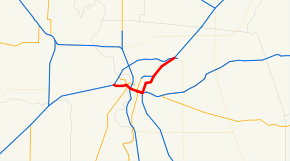 Business 80, with both the US 50 segment and the unsigned SR 51 segment highlighted in red | ||||
| Route information | ||||
| Maintained by Caltrans | ||||
| Length | 13.82 mi[1] (22.24 km) | |||
| Existed | 1981 (from I-80)[2] – present | |||
| Component highways |
Unsigned | |||
| Major junctions | ||||
| West end |
| |||
| ||||
| East end |
| |||
| Location | ||||
| Counties | Yolo, Sacramento | |||
| Highway system | ||||
| ||||
.svg.png)
Interstate 80 Business, called the Capital City Freeway in its entirety and also known as Business 80, is a business loop of Interstate 80 through Sacramento. It is also informally referred to as "Cap City Freeway" and "Biz 80". The entire route is a freeway.
It originally carried mainline Interstate 80 through Sacramento until the early 1980s. The eastern half, originally known as the Elvas Freeway, was initially grandfathered into the Interstate Highway system; however, plans to upgrade or realign this portion to meet Interstate Highway standards were cancelled. As such, the I-80 designation through Sacramento was moved to a northern bypass of the city that had previously been signed Interstate 880, and the former routing was then designated as Business Route 80.
Business Route 80 then consisted of two connected segments. The western segment became concurrently signed with U.S. Route 50 and also carried the unsigned designation of Interstate 305. The eastern segment was assigned the unsigned designation of State Route 51. After travelers complained that Business 80 was difficult to follow, it was named the Capital City Freeway in 1996. As part of a re-signing project beginning in 2016, references to Business 80 on the western segment are being removed and the new signs installed instead marking the route as only US 50.
Route description
SR 51 is part of the California Freeway and Expressway System,[3] and both SR 51 and I-305 are part of the National Highway System,[4] a network of highways that are considered essential to the country's economy, defense, and mobility by the Federal Highway Administration.[5] Currently, it is the only business route in California to exist as a freeway.
Western section of Business 80
The western section of Business 80 begins in West Sacramento at Interstate 80, where I-80 leaves the West Sacramento Freeway onto the Beltline Freeway (which travels north of the Bryte neighborhood, over the Sacramento River, and into the Natomas area). This interchange in West Sacramento is also the current west end of U.S. Route 50 and the west end of the unsigned I-305.
In downtown West Sacramento, Business 80 and US 50 split from the West Sacramento Freeway, which is now locally maintained in part over the Tower Bridge up to the door of the capitol, but was once signed as State Route 275. Business 80 crosses the Sacramento River on the Pioneer Memorial Bridge, intersecting with Interstate 5 on the east bank. State Route 99 once ran along I-5 to the north and Business 80 to the east, but this is now signed TO SR 99. After crossing I-5, Business 80 runs on top of an embankment between "W" and "X" streets. The W-X Freeway gets its name from running parallel to "W" and "X" streets.[6]
Beginning in 2016, signs on the western section were being updated to remove references to Business 80 and instead sign the route only as US Highway 50. The eastern section remains signed as Business 80.[7] This was intended to reduce confusion between multiple highways numbered 80.
Eastern section of Business 80
At an interchange southeast of downtown Sacramento, Business 80 turns north onto the south end of unsigned SR 51. US 50 continues east, State Route 99 heads south, and the "hidden" I-305 ends. The elevated freeway carrying Business 80 east of downtown is between 29th and 30th Streets, and an older section beginning at A Street and continuing northeast was originally known as the Elvas Freeway (and originally signed as U.S Highway 99 East). On this section of freeway, Business 80 crosses the American River before its northeast-bound merge with the North Sacramento Freeway (the northern portion of State Route 160 towards downtown).
The North Sacramento Freeway, originally a portion of U.S. Route 40, originally ran west from Marconi Avenue to an intersection with Del Paso Boulevard. The section from Arden Way eastbound back to Marconi Avenue is now part of the currently named Capital City Freeway (while the SR 160 section retains the original freeway name). The original North Sacramento Freeway connected to the Roseville Freeway at the curve north of Marconi Avenue (commonly known as the Marconi Curve, where the freeway once ended at Auburn Boulevard). At the east end of Business 80, the Roseville Freeway continues northeast to Roseville as Interstate 80, while the short unsigned State Route 244 heads east to Auburn Boulevard.
I-80 heads in both directions around the north side of Sacramento. A partially built portion of a never completed replacement freeway for SR 51, in the median of I-80, now serves as parking and access for the northernmost three stations (Watt/I-80, Watt/I-80 West, and Roseville Road) on the Sacramento Regional Transit District's light rail Blue Line. If this replacement freeway had been completely built as originally planned, I-80 would have continued south following the railroad tracks going through the Ben Ali neighborhood of North Sacramento, crossed over SR 160, and joined with the Elvas Freeway portion just north of A Street.
History
The State Division of Highways (predecessor to Caltrans) constructed Sacramento’s freeways system incrementally from the 1940s to the 1970s. The plan for the Elvas Freeway was presented in the Sacramento Area Traffic Survey in 1947-1948, and the freeway was built between 1950 and 1955. The Division of Highways built the 2.9 mile Elvas Freeway as a four-lane divided highway (with provisions for a six-lane freeway) to connect with the North Sacramento Freeway in the vicinity of Arden Way. The new freeway’s southern terminus was the surface roads at 29th and 30th streets. At the time the Elvas Freeway was conceived and built, the Division of Highways was already considering an elevated freeway along the 29th Street / 30th Street corridor that would connect with the then proposed South Sacramento Freeway (SR 99). The Division of Highways went on to complete the Fort Sutter Viaduct along the 29th Street / 30th Street corridor in 1968, which led the Division of Highways to convert the Elvas Freeway from four to six lanes in 1965.[8] The Sacramento River Viaduct was completed in 1966, the Southside Park Viaduct was completed in 1967, and the rest of the W-X Freeway was completed in 1968.[1] The Elvas Freeway was connected to the W-X Freeway to the west and US 50 to the east, in 1968 and 1971 respectively.[8] The W-X Freeway and the Elvas Freeway were signed as I-80.
Between 1968 and 1975 a 5.2 mile bypass was proposed that was to straighten the alignment of I-80 and increase its capacity.[9] The Sacramento City Council voted in September 1979 to delete the I-80 Bypass freeway from the Interstate System.[10] In 1980 California submitted to AASHTO proposals to relocate I-80 in Sacramento onto then I-880, extend U.S. Route 50 west to cover the west half of old I-80, and to assign I-305 to the west half of old I-80, and delete I-880 in the Sacramento area. AASHTO approved these proposals.[11] The next year, the California State Legislature extended U.S. Route 50 west to cover the west half of old I-80, and the east half was assigned the new SR 51 number and designated as Business Loop 80.[2]
The old I-80 was never signed as US 50 (alone) or SR 51, but as a business route. Unlike most business routes in California, which run along locally-maintained streets through a downtown area, Business 80 was not assigned to the pre-freeway alignment of U.S. Route 40, but to a freeway. The existence of two freeways, both numbered 80, caused some confusion, and in 1996 the full route was given the Capital City Freeway name at the request of the Sacramento Area Council of Governments.[12] This name appears on overhead signs at prominent interchanges. The route is referred to as Business 80, the 80, Biz 80, Capital City Freeway, Cap City Fwy, and US 50 (western section only) by residents and mapmakers. Caltrans does not normally use the Business 80 designation, except for signage and other related concepts like Cal-NExUS exit numbers (which are continuous along the business loop). Caltrans refers to the western half as US 50 and the eastern half as SR 51 for traffic condition reporting.[13]
Under the California Streets and Highways Code § 351.1, "Route 51 shall be signed Interstate Business Loop 80". There is no such mandate under § 350 for Route 50, thus Caltrans was able to start removing references to Business 80 on signage in the US 50 segment.
Despite Caltrans' official signage and reporting practices, mapmakers may still show the I-305 and SR 51 designations, as well as the Business 80/US 50 concurrency on the western segment. The SR 99 concurrency, running along US 50 and I-5 to northern Sacramento, is also not officially designated by Caltrans, but mapmakers will still also often show it as such.
An earlier State Route 51 was defined on July 1, 1964 on a section of pre-1964 Legislative Route 2, providing a loop east of Interstate 5 (pre-1964 Legislative Route 174 there) through Orange, around the Orange Crush Interchange. It was removed from the state highway system in 1965.[14][15]
Exit list
The entire route is in Sacramento, Sacramento County.
| mi[16] | km | Exit[16] | Destinations | Notes | |||
|---|---|---|---|---|---|---|---|
| See US 50 exits 1–5 for the western segment | |||||||
| 0.00 | 0.00 | 6A | East end of US 50 concurrency; east end of unsigned I-305; south end of unsigned SR 51; exit number is for US 50 east, no exit number eastbound; US 50 west exit 6C | ||||
| 0.24 | 0.39 | 6C | P Street | Westbound exit and eastbound entrance | |||
| 0.84 | 1.35 | 7A | N Street | Eastbound exit and westbound entrance | |||
| J Street | Westbound exit and eastbound entrance | ||||||
| 1.20 | 1.93 | 7B | H Street | Eastbound exit and westbound entrance | |||
| E Street | Westbound exit and eastbound entrance | ||||||
| 3.36 | 5.41 | 9A | Exposition Boulevard – Cal Expo | Eastbound entrance is via SR 160 | |||
| 3.69 | 5.94 | 9B | Former US 40[17] | ||||
| 4.06 | 6.53 | 10A | Arden Way | Eastbound exit is part of exit 9B | |||
| 4.74 | 7.63 | 10B | El Camino Avenue – Carmichael | Signed as exit 10 eastbound | |||
| 5.50 | 8.85 | 11 | Auburn Boulevard, Marconi Avenue | No eastbound entrance | |||
| 5.96 | 9.59 | 12A | Howe Avenue | Eastbound exit and entrance | |||
| 6.21 | 9.99 | 12B | Auburn Boulevard, Bell Street | Eastbound exit only; Auburn Boulevard was former US 40 | |||
| 6.79 | 10.93 | 12C | Fulton Avenue | Signed as exit 12 westbound | |||
| 7.97 | 12.83 | 14B | Watt Avenue | Signed as exits 14A (south) and 14B (north) eastbound; connects to I-80 west | |||
| 8.59 | 13.82 | 14C | Auburn Boulevard (SR 244) | No eastbound exit; signed as exit 14A westbound; Auburn Boulevard was former US 40 | |||
| 8.86 | 14.26 | Eastern terminus; north end of unsigned SR 51; I-80 west exit 95 | |||||
1.000 mi = 1.609 km; 1.000 km = 0.621 mi
| |||||||
See also

- Interstate 80 in California
References
- 1 2 California Department of Transportation (April 2018). "Log of Bridges on State Highways". Sacramento: California Department of Transportation.
- 1 2 "Route 50 and Route 51 Legislative Definitions". California Legislative Information. State of California. pp. 350, 351, 351.1. Retrieved 2 May 2018.
- ↑ California State Legislature. "Section 250–257". Streets and Highways Code. Sacramento: California State Legislature. Retrieved June 9, 2017.
- ↑ Federal Highway Administration (March 25, 2015). National Highway System: Sacramento, CA (PDF) (Map). Scale not given. Washington, DC: Federal Highway Administration. Retrieved October 14, 2017.
- ↑ Natzke, Stefan; Neathery, Mike & Adderly, Kevin (June 20, 2012). "What is the National Highway System?". National Highway System. Washington, DC: Federal Highway Administration. Retrieved July 1, 2012.
- ↑ Jones, Dave (19 June 2014). "Fix 50 and UC Davis: Resources". ucdavis.edu. The Regents of the University of California, Davis campus. Retrieved 4 May 2018.
- ↑ http://caltrans.ca.gov/hq/esc/oe/project_ads_addenda/03/03-4F7104/plans/03-4f7104_plans.pdf
- 1 2 "APPENDIX F Historic Assessment of A Street Bridge" (PDF). JRP Historical Consulting LLC. 4 September 2013. p. 4. Retrieved 4 May 2018.
- ↑ R. A. Johnston, et. al. "Politics and Technical Uncertainty in Transportation Investment Analysis" (PDF). p. 462.
Reprinted from Transportation Research -A vol 21A, no 6, pp 459-475 (1988)
- ↑ Sacramento Light Rail Transit Project: Environmental Impact Statement. US Department of Transportation. August 1983. p. 3-10. Retrieved 3 May 2018.
- ↑ Special Committee on U.S. Route Numbering (November 14, 1980). "Route Numbering Committee Agenda" (PDF) (Report). Washington, DC: American Association of State Highway and Transportation Officials. p. 1. Retrieved 2 May 2018 – via Wikimedia Commons.
- ↑ 2016 Named Freeways, Highways, Structures and Other Appurtenances in California (PDF). California Department of Transportation. January 2017. p. 38. Retrieved 2 May 2018.
- ↑ "District 3 Lane Closures". Retrieved 5 May 2018.
List of highways shows 50 and 51, but not BUS 80.
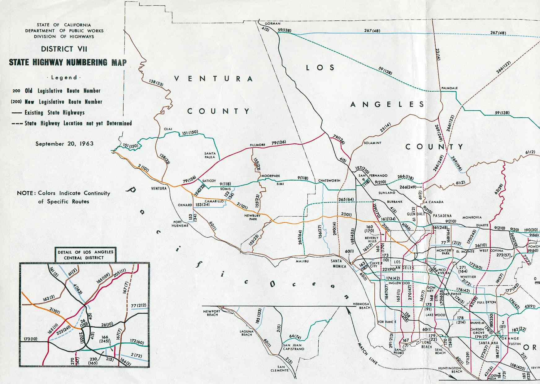
- ↑ District VII State Highway Numbering Map, September 20, 1963
- ↑ "Route 51". California Highways. Retrieved October 4, 2014.
- 1 2 Warring, KS (June 18, 2008). "Interstate 80 Business Interchanges" (PDF). California Numbered Exit Uniform System. California Department of Transportation. Retrieved August 6, 2016.
- ↑ "Elvas Freeway - US 99E (photo of signage)". Joel Windmiller. Archived from the original on February 17, 2004. Retrieved February 27, 2009.
External links
| Wikimedia Commons has media related to Interstate 80 Business (Sacramento, California). |
Route map:
- California @ AARoads.com - Business Loop I-80 Sacramento
- The Highwayman's Road Reports - Elvas Freeway, North Sacramento Freeway and West Sacramento Freeway
Crossings of the Sacramento River | ||||
|---|---|---|---|---|
| ||||
| ||