Interstate 595 (Florida)
| |||||||
|---|---|---|---|---|---|---|---|
|
Port Everglades Expressway State Road 862 | |||||||
| Route information | |||||||
| Maintained by FDOT | |||||||
| Length | 12.860 mi[1] [2] (20.696 km) | ||||||
| Existed | June 11, 1990 – present | ||||||
| Major junctions | |||||||
| West end |
| ||||||
|
| |||||||
| East end |
| ||||||
| Location | |||||||
| Counties | Broward | ||||||
| Highway system | |||||||
| |||||||


Interstate 595 (I-595), also known as the Port Everglades Expressway and as the unsigned State Road 862 (SR 862), is a 12.860-mile (20.696 km) Interstate highway that connects Interstate 75 and Alligator Alley in the west with Florida's Turnpike, Interstate 95, Fort Lauderdale-Hollywood International Airport, US 1, and SR A1A before terminating at Port Everglades in the east. The interstate route was conceived in 1969, and planned as an interstate starting in 1974. Construction began in 1984, with the highway opening in stages in the late 1980s, with completion in 1991. The reversible tolled express lanes opened in 2014.
Route description
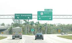
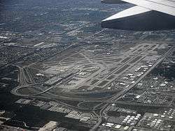
The Interstate Highway begins in Sunrise as the eastern part of an interchange with Interstate 75 on the southern and western ends (I-75 "north" leads into Alligator Alley on the west side) and the Sawgrass Expressway on the northern end. For most of its length, State Road 84 (the former number for Alligator Alley) runs parallel to the highway, acting as an access road on either side of the Interstate. From the western terminus, the highway heads east to Davie, acting as a commuter route between the western fringes of the populated part of Broward County and Fort Lauderdale. At University Drive, I-595 goes below a partial stack interchange. Three miles east of that interchange, it meets with Florida's Turnpike and U.S. Highway 441. In Fort Lauderdale, I-595 intersects with I-95 at the northwestern end of the airport. At the eastern end of the airport, it has its final interchange with U.S. Highway 1 (which runs concurrently with State Road A1A at the interchange), providing access to the airport and Port Everglades. The eastern terminus consists of two lanes for US 1 southbound, two for US 1 northbound and two lanes for Port Everglades via Eller Drive. The exit for southbound US 1 has a ramp to the airport. State Road A1A is not listed on the exit signs.
History
Interstate 595 grew out of a highway plan for connecting Port Everglades with Alligator Alley, first conceived in 1969 as the Port Expressway. In 1974, once I-75 was rerouted to Broward County on Alligator Alley as a part of its eastern connection from Naples, it was proposed to be built as an interstate, likely as the southmost end of I-75. However, when the southern terminus of I-75 was moved from Broward to Dade County at the Palmetto Expressway/Gratigny Parkway in the late 1970s, it delayed the construction of the trans-Broward expressway.
In the early 1980s, I-595 was planned to be partially a toll highway to cover its cost of construction. By the time construction started on July 26, 1984, the tolls for the highway vanished, and it was built with only minor changes in its route. The first section, between I-75 and Hiatus Road opened in May 1988, with the section between Florida's Turnpike and US 1 opening on February 24, 1989, and the last section, connecting the disjointed sections opening on October 21, 1989. The highway was designated as I-595 on June 11, 1990, and the Rainbow Interchange with I-95 was completed on March 22, 1991, the last unfinished interchange of the original plan.[3]
The portion of the highway between I-95 and US 1 follows the right of way of the Port Everglades Railroad tracks that had previously run from the CSX railroad to Port Everglades.
In 2002, I-595, along with most of Florida's interstates, switched over from a sequential exit numbering system to a mileage based exit numbering system.[4] Numbers were changed again[5] at about the time the express lanes were opened in spring of 2014.
Express lanes

The $1.8 billion tolled SunPass express lanes project in the middle of the expressway to relieve the traffic congestion opened for test use on March 26, 2014 and started tolling on April 9, 2014.[6] The Express Lanes will significantly improve the capacity and operations of the I-595 corridor by providing three additional at-grade lanes in the median of the corridor. The lanes will reverse direction in peak travel times (eastbound in the a.m./westbound in the p.m.). To maximize the operational efficiency, the lanes will have tolls at varying rates throughout the day to optimize traffic flow, and access to and from the lanes will only be allowed west of 136th Avenue, east of U.S. 441/State Road 7, and through a direct connection to the median of Florida's Turnpike, removing long distance commuter traffic from the general purpose lanes. FDOT will retain control of the toll revenue and toll rates.
Exit list
Mainline
Exits 1-7 feed into the SR 84 frontage roads. The entire route is in Broward County.
| Location | mi[1] | km | Old exit [4][5] | New exit | Destinations | Notes | |
|---|---|---|---|---|---|---|---|
| Sunrise–Weston– Davie tripoint | 0.000 | 0.000 | – | – | Western terminus; I-75 exit 19 | ||
| Southern terminus of SR 869 | |||||||
| Express lanes | Western terminus of express lanes | ||||||
| Davie–Plantation line | 0.569 | 0.916 | 1A | 1 | Southwest 136th Avenue | Eastbound exit/westbound entrance shares ramps with exit 2. | |
| 0.525 | 0.845 | – | – | Exit and entrance to serve SR 869 | |||
| 1.145 | 1.843 | 1B | 2 | Westbound exit shares a ramp with exit 3. | |||
| 2.052 | 3.302 | 2 | 3 | Hiatus Road | |||
| 3.454 | 5.559 | 3 | 4 | Nob Hill Road | Eastbound exit shares a ramp with exit 3. | ||
| 4.249 | 6.838 | 4 | 5 | Access to West Side Regional Medical Center | |||
| 5.504 | 8.858 | 5 | 6 | Eastbound exit shares a ramp with exit 5. | |||
| 6.092 | 9.804 | – | 7 | Davie Road | |||
| 6.970 | 11.217 | – | – | West end of SR 84 concurrency; signed with exit 8 | |||
| 7.336 | 11.806 | 8A | 8 | Exits 54-54X on Turnpike | |||
| 8.080 | 13.003 | – | – | Eastern terminus of express lanes | |||
| Davie–Fort Lauderdale– Broadview Park tripoint | 8.409 | 13.533 | 8B | 9 | Shared ramp with exit 8 in both directions; signed as exits 9A (north) and 9B (south) | ||
| 8.329 | 13.404 | 9 | 9C | East end of SR 84 concurrency | |||
| Fort Lauderdale–Hollywood– Dania Beach tripoint | 10.373 | 16.694 | – | 10 | Rainbow Interchange; exits 24-26 on I-95; πsigned as exits 10A (north) and 10B (south) | ||
| 12.544 | 20.188 | 12A–B | 12A | Westbound exit is signed via exit 12C/Originally signed as 12A (US 1 south) and 12B (Airport) from 1990-2002[7] | |||
| 12C | 12B | Eastern terminus of I-595; westbound exit is via exit 12C. | |||||
| – | 12C | Eastbound exit and westbound entrance merging ramps and westbound exit and eastbound entrance at-grade intersection; signed as exit 12 westbound | |||||
| 12.860 | 20.696 | – | – | McIntosh Road / Eller Drive – Port Everglades | Eastern terminus of SR 862; continuation east via Eller Drive | ||
1.000 mi = 1.609 km; 1.000 km = 0.621 mi
| |||||||
Express lanes
The entire route is in Broward County.
| Location | mi[8] | km | Exit | Destinations | Notes |
|---|---|---|---|---|---|
| Sunrise–Weston– Davie tripoint | 0.000 | 0.000 | – | Exit 19 on I-75 | |
| Davie–Plantation line | 1.413 | 2.274 | – | Westbound exit and eastbound entrance, peak-direction only | |
| 1.869 | 3.008 | Sunpass toll gantry ($0.50-$2.00 dynamic pricing) | |||
| 7.762 | 12.492 | 8 | Turnpike exit 54X; eastbound exit and westbound entrance | ||
| 8.796 | 14.156 | – | Roadway defaults to I-595 mainline | ||
| 1.000 mi = 1.609 km; 1.000 km = 0.621 mi | |||||
Frontage roads
See also


References
- 1 2 Florida Department of Transportation (March 15, 2015). "Straight Line Diagram of Road Inventory" (PDF). Retrieved December 24, 2015.
- ↑ Florida Department of Transportation. "FDOT Interchange Report" (PDF). Archived from the original (PDF) on February 8, 2012. Retrieved October 4, 2007.
- ↑ "History of Interstate 595". Archived from the original on 12 October 2004. Retrieved 5 October 2014.
- 1 2 "Florida's New Interstate Exit Numbers for I-595". Florida Department of Transportation. Archived from the original on December 6, 2010. Retrieved 2010-11-18.
- 1 2 Interstate Exit Numbers for I-595 Archived 2010-12-06 at the Wayback Machine., accessed March 2014
- ↑ Turnbull, Michael (23 March 2014). "I-5955 express lanes ready for test traffic". Sun-Sentinel. Retrieved 23 March 2014.
- ↑
- ↑ Florida Department of Transportation (May 5, 2014). "Straight Line Diagram of Road Inventory" (PDF). Retrieved December 24, 2015.
External links
Route map:
| Wikimedia Commons has media related to Interstate 595 (Florida). |
| ||