Fujiwhara effect
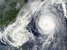
The Fujiwhara effect, sometimes referred to as the Fujiwara effect, Fujiw(h)ara interaction or binary interaction, is a phenomenon that occurs when two nearby cyclonic vortices orbit each other and close the distance between the circulations of their corresponding low-pressure areas. The effect is named after Sakuhei Fujiwhara, the Japanese meteorologist who initially described the effect. Binary interaction of smaller circulations can cause the development of a larger cyclone, or cause two cyclones to merge into one. Extratropical cyclones typically engage in binary interaction when within 2,000 kilometres (1,200 mi) of one another, while tropical cyclones typically interact within 1,400 kilometres (870 mi) of each other.
Description
When cyclones are in proximity of one another, their centers will begin orbiting cyclonically (counter-clockwise in the Northern Hemisphere and clockwise in the Southern Hemisphere)[2] about a point between the two systems due to their cyclonic wind circulations. The two vortices will be attracted to each other, and eventually spiral into the center point and merge. It has not been agreed upon whether this is due to the divergent portion of the wind or vorticity advection.[3] When the two vortices are of unequal size, the larger vortex will tend to dominate the interaction, and the smaller vortex will orbit around it. The effect is named after Sakuhei Fujiwhara, the Japanese meteorologist who initially described it in a 1921 paper about the motion of vortices in water.[4][5]
Tropical cyclones
Tropical cyclones can form when smaller circulations within the Intertropical Convergence Zone merge.[6] The effect is often mentioned in relation to the motion of tropical cyclones, although the final merging of the two storms is uncommon. The effect becomes noticeable when they approach within 1,400 kilometres (870 mi) of each other. Rotation rates within binary pairs accelerate when tropical cyclones close within 650 kilometres (400 mi) of each other.[7] Merger of the two systems (or shearing out of one of the pair) becomes realized when they are within 300 kilometres (190 mi) of one another.[8]
Examples
North Atlantic
Hurricane Iris of the 1995 Atlantic hurricane season interacted with Hurricane Humberto, before interacting with and absorbing Tropical Storm Karen on September 3.[9]
In 2005, the remnant low of Tropical Depression Thirteen moved northward and then northeastward around a non-tropical low located to the north of the system. It briefly strengthened into Tropical Storm Lee. Thereafter, Lee weakened back to a tropical depression as it moved northeastward and northwestward around the eastern side of the non-tropical low and eventually absorbed the non-tropical low.[10] In the same year, Alpha was absorbed by Wilma.
In 2018, Hurricane Helene steered the weaker Tropical Storm Joyce. Helene moved to the north towards Europe while Joyce was spun southward towards the Azores. This interaction may have led to Tropical Storm Joyce's eventual demise.
Northeast Pacific
In 1974, Hurricanes Kirsten and Ione interacted in a Fujiwara interaction, as Ione was pulled north east, while Kirsten was pulled to the north west.[11] In the same year, Hurricanes Francesca and Gretchen interacted with each other, until they merged on July 19.[12]
In 2001, Hurricane Gil absorbed Tropical Storm Henriette but associated convection totally dissipated during the merger and did not return afterwards.
In 2005, Tropical Storm Lidia was absorbed by Hurricane Max.[13]
In 2014, Hurricane Karina initially traveled west, but was steered back east by an interaction with Hurricane Lowell. It later weakened, and its remnants were later absorbed by Hurricane Marie.[14]
In 2017, Hurricanes Hilary and Irwin interacted. Hilary stopped Irwin's westward movement, and caused Irwin to turn northward.[15]
In 2018, Hurricane John absorbed a nearby weaker storm, Tropical Storm Ileana.[16]
Northwest Pacific

In September 1994, Typhoon Pat and Tropical Storm Ruth completed a full orbit around their centroid before collapsing into a single cyclone.[17] In August 1997, Tropical Storm Yule merged with Tropical Depression 16W.[18]
In October 2009, Typhoon Parma interacted with Typhoon Melor, affecting the movement of Parma. Parma was moving through the South China Sea but made recurved to the southeast, so it made its second and third landfall over northern Luzon. In addition, due to the interaction with Melor, Parma weakened, becoming a tropical storm by October 4.
In November 2009, Typhoon Nida absorbed Tropical Depression 27W (Urduja) and become a powerful typhoon.
In August 2010, a Fujiwara interaction occurred between Tropical Storm Namtheun and Severe Tropical Storm Lionrock. Namtheun turned southwestward while Lionrock turned eastward. Later, Namtheun weakened into a tropical depression in the Taiwan Strait and was absorbed by Lionrock.
In August 2012, a Fujiwhara interaction occurred between Typhoon Tembin and Bolaven. Tembin was moving west, while Bolaven caused Tembin to turn east, resulting in a counter-clockwise loop of Tembin which caused torrential rain in Southern Taiwan.
In August 2013, Severe Tropical Storm Pewa absorbed Tropical Storm Unala. In August 2016, a Fujiwhara interaction occurred between Typhoons Mindulle and Lionrock. Lionrock was moving west-southwest, while Mindulle caused Lionrock to turn east, resulting in Lionrock being spun to the south of Japan.
In July 2017, Typhoon Noru absorbed Tropical Storm Kulap. Later in the same month, a Fujiwhara interaction occurred between Typhoon Nesat and Tropical Storm Haitang. Nesat caused Haitang to turn northeastward, but the remnants of Nesat were eventually absorbed by Haitang over Fujian.
Southwest Indian Ocean
In 2008, Tropical Cyclone Fame began orbiting Tropical Cyclone Gula with the stronger storm, Gula, absorbing Fame. In 2012, Cyclone Giovanna and Tropical Storm Hilwa interacted in a Fujiwara interaction; Giovanna was pulled to the north, while Hilwa was pulled to the south.
South Pacific Ocean
During January 1998, Cyclones Susan and Ron interacted with each other, before Susan absorbed Ron on January 9.[19]
Extratropical cyclones
Binary interaction is seen between nearby extratropical cyclones when within 2,000 kilometres (1,200 mi) of each other, with significant acceleration occurring when the low-pressure areas are within 1,100 kilometres (680 mi) of one another. Interactions between their circulations at the 500 hPa level (18,000 feet above sea level) behave more predictably than their surface circulations.[7] This most often results in a merging of the two low-pressure systems into a single extratropical cyclone, or can less commonly result in a mere change of direction of one or both of the cyclones.[20] The precise results of such interactions depend on factors such as the size of the two cyclones, their distance from each other, and the prevailing atmospheric conditions around them.
See also
References
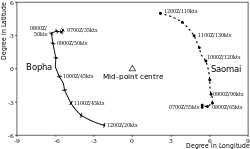
- ↑ Wu, Chun-Chieh; Huang, Treng-Shi; Huang, Wei-Peng; Chou, Kun-Hsuan (July 2003). "A New Look at the Binary Interaction: Potential Vorticity Diagnosis of the Unusual Southward Movement of Tropical Storm Bopha (2000) and Its Interaction with Supertyphoon Saomai (2000)". Monthly Weather Review. 131: 1289–1300. Bibcode:2003MWRv..131.1289W. doi:10.1175/1520-0493(2003)131<1289:ANLATB>2.0.CO;2.
- ↑ Landsea, Chris (2009-02-06). "Subject: D3) Why do tropical cyclones' winds rotate counter-clockwise (clockwise) in the Northern (Southern) Hemisphere?". Atlantic Oceanographic and Meteorological Laboratory. Retrieved 2009-12-28.
- ↑ DeMaria, Mark; Johnny C. L. Chan (August 1984). "Comments on "A Numerical Study of the Interactions between Two Cyclones". Mon. Wea. Rev. 112: 1643–1645. Bibcode:1984MWRv..112.1643D. doi:10.1175/1520-0493(1984)112<1643:CONSOT>2.0.CO;2.
- ↑ Fujiwhara, Sakuhei (1921). "The natural tendency towards symmetry of motion and its application as a principle in meteorology". Q. J. R. Met. S. 47 (200): 287&ndash, 293. Bibcode:1921QJRMS..47..287F. doi:10.1002/qj.49704720010.
- ↑ "Fujiwhara effect describes a stormy waltz". USA Today. November 1, 2007. Retrieved 2008-02-21.
- ↑ Kieu, Chanh Q.; Da-Lin Zhang (June 2010). "Genesis of Tropical Storm Eugene (2005) from Merging Vortices Associated with ITCZ Breakdowns. Part III: Sensitivity to Various Genesis Parameters". J. Atmos. Sci. 67: 1745–1758. Bibcode:2010JAtS...67.1745K. doi:10.1175/2010JAS3227.1.
- 1 2 Ziv, B; P. Alpert (1995-05-01). "Rotation of Binary Cyclones - A Data Analysis Study". J. Atmos. Sci. 52 (9): 1357–1363. Bibcode:1995JAtS...52.1357Z. doi:10.1175/1520-0469(1995)052<1357:ROBCDA>2.0.CO;2.
- ↑ Prieto, Ricardo, Brian D. McNoldy, Scott R. Fulton, and Wayne H. Schubert (November 2003). "A Classification of Binary Tropical Cyclone–Like Vortex Interactions". Mon. Wea. Rev. 131: 2659. Bibcode:2003MWRv..131.2656P. doi:10.1175/1520-0493(2003)131<2656:acobtc>2.0.co;2.
- ↑ Rappaport, Edward N. (2000-11-02). Preliminary Report: Hurricane Iris National Hurricane Center. Retrieved on 2012-11-20.
- ↑ Avila, Lixion A. (2005-12-07). Tropical Cyclone Report: Tropical Storm Lee. National Hurricane Center. Retrieved on 2012-11-20.
- ↑ http://weather.about.com/od/hurricaneformation/a/Fujiwhara.htm
- ↑ Towry, Sharon (June 1975). "Eastern North Pacific Tropical Cyclones, 1974. Part 2" (PDF). Mon. Wea. Rev. 103 (6): 550–559. Bibcode:1975MWRv..103..550T. doi:10.1175/1520-0493(1975)103<0550:ENPTCP>2.0.CO;2. Retrieved November 15, 2012.
- ↑ Knabb, Richard D. (2006-04-05). NHC Tropical Cyclone Report: Hurricane Max. National Hurricane Center. Retrieved on 2012-11-20.
- ↑ Brown, Daniel P. (2014-11-17). NHC Tropical Cyclone Report: Hurricane Karina. National Hurricane Center. Retrieved on 2017-07-27.
- ↑ Zelinsky, David A. (2018-01-12). NHC Tropical Cyclone Report: Hurricane Irwin. National Hurricane Center. Retrieved on 2018-10-14.
- ↑ Daniel P. Brown (August 7, 2018). "Remnants of Ileana Discussion Number 12". Miami, Florida: National Hurricane Center. Retrieved August 7, 2018.
- ↑ Joint Typhoon Warning Center - Typhoon Pat Archived 2011-06-07 at the Wayback Machine. (PDF)
- ↑ "1997 Annual Tropical Cyclone Report" (PDF). Joint Typhoon Warning Center. 1998. Retrieved November 24, 2012.
- ↑ Padgett, Gary (1998). "Monthly Global Tropical Cyclone Summary January 1998". Australian Severe Weather. Retrieved 2011-06-27.
- ↑ Ziv, B.; P. Alpert (December 2003). "Rotation of mid-latitude binary cyclones: a potential vorticity approach". Theor Appl Climatol. 76 (3–4): 189–202. Bibcode:2003ThApC..76..189Z. doi:10.1007/s00704-003-0011-x. Retrieved 2006-10-21.